Push-broom LiDAR-based soil surface morphology monitoring device and soil surface morphology monitoring and data analysis method

A soil surface and monitoring device technology, applied in the field of soil research tools, can solve the problems of inability to reflect surface fluctuations and expansions, inability to measure soil three-dimensional shape information, and application limitations, so as to reduce the problem of missing soil surface information and make up for scanning Small range, avoiding the effect of external light interference

Active Publication Date: 2018-03-13
INST OF SOIL SCI CHINESE ACAD OF SCI
View PDF8 Cites 8 Cited by
  • Summary
  • Abstract
  • Description
  • Claims
  • Application Information

AI Technical Summary

Problems solved by technology

However, the position of the laser head cannot be moved by this method, and the three-dimensional shape information of the soil cannot be measured [1]
Although X-ray layered scanning technology (CT technology) can realize the reconstruction of the three-dimensional space structure of the soil, the instrument is expensive, and destructive sampling is necessary, and the sample size is strictly limite

Method used


Image

  • Push-broom LiDAR-based soil surface morphology monitoring device and soil surface morphology monitoring and data analysis method
  • Push-broom LiDAR-based soil surface morphology monitoring device and soil surface morphology monitoring and data analysis method
  • Push-broom LiDAR-based soil surface morphology monitoring device and soil surface morphology monitoring and data analysis method

Examples


Embodiment 1

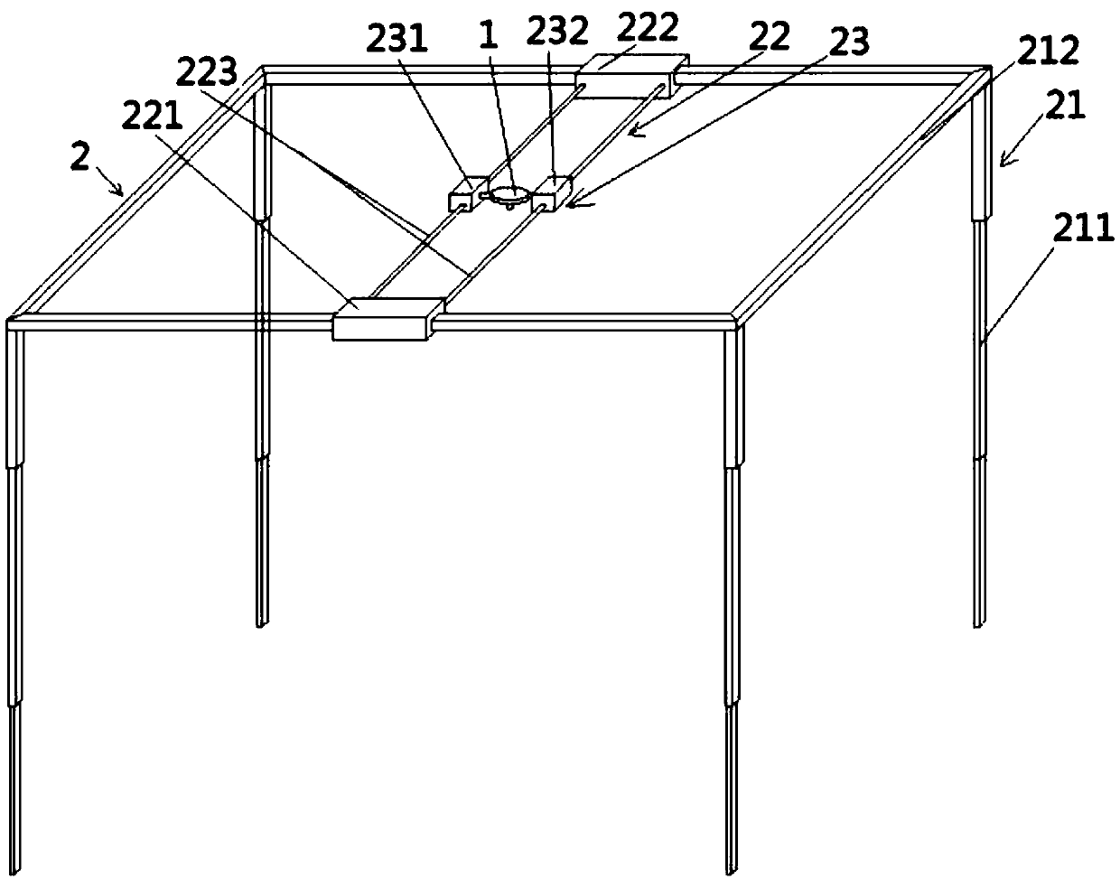
[0038] This soil surface morphology monitoring device based on push-broom LiDAR includes push-broom laser ranging radar 1, radar carrying platform 2, and data processing center (not shown in the figure);

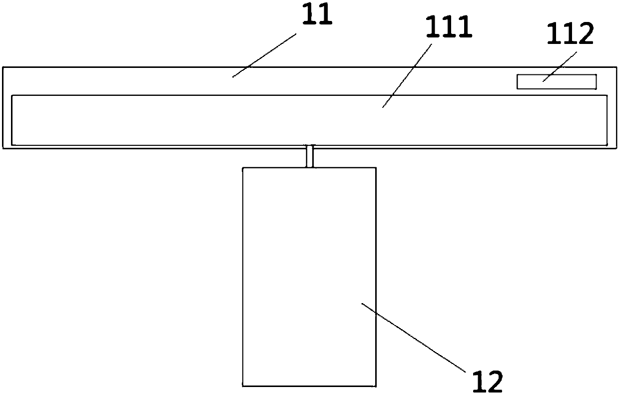
[0039] The push-broom laser ranging radar includes a radar main body 11 and a laser ranging module 12, and the radar main body is provided with a drive motor 111 that drives the laser ranging module to rotate along the rotation axis and a wired / wireless data transmission module 112, wherein The rotation axis is in the direction of the Z axis, and the wired / wireless data transmission module is used to receive control signals and send radar data;

[0040] The data processing center is used to control the movement of the radar carrying platform, control the movement of the drive motor, receive and process push-broom laser ranging radar data;

[0041] The radar carrying platform 2 includes a bracket main body 21, an X-axis traveling device 22, a Y-axis traveling device 23 and a ...

Embodiment 2

[0048] The soil surface morphology monitoring and data analysis method based on the push-broom LiDAR is realized based on the soil surface morphology monitoring device based on the push-broom LiDAR in Example 1. The steps include:

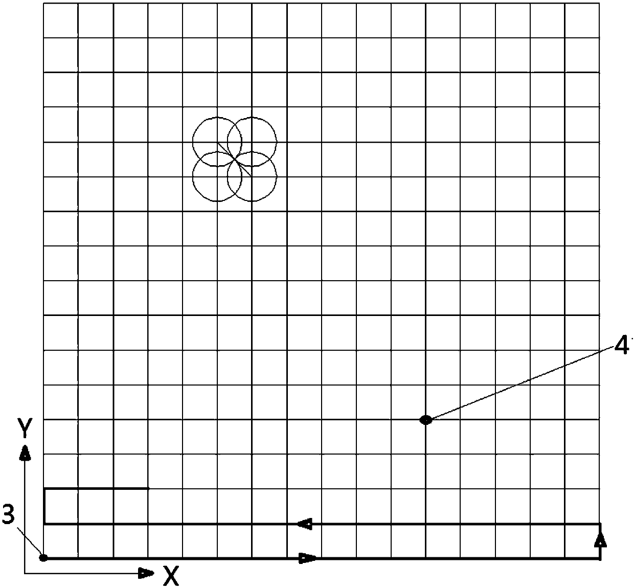
[0049] (1) Water-saturated soil is placed in a surface dish with a diameter of 20 cm. As the surface morphology monitoring object, the soil surface is simulated into a grid according to the scanning radius of the push-broom laser ranging radar. The size of the grid is: grid diagonal Line = scan radius * 2, with any corner as the origin 3, and other intersection points of the grid as nodes 4;

[0050] (2) Data acquisition: the push-broom laser ranging radar scans the soil surface to be measured from the origin within the plane limited by the radar-mounted platform, and moves to the next node for scanning after completion, until all nodes are scanned. Send it to the computer for processing, and the number of scans, the position of the node, and the m...


PUM


Abstract

A push-broom LiDAR-based soil surface morphology monitoring device disclosed by the present invention comprises a push-broom laser ranging radar, a radar carrying platform and a data processing center. The radar carrying platform is used to drive the push-broom laser ranging radar to advance along the X-axis and Y-axis directions, the push-broom laser ranging radar comprises a radar main body anda laser ranging module, and the data processing center is used to control the motion of the radar carrying platform and the motion of a driving motor, receive and process the data of the push-broom laser ranging radar. The present invention also discloses a soil surface morphology monitoring and data analysis method based on the device. The device and the method of the present invention can capture the three dimensional morphology structure of a soil surface fine, at the same time, can avoid the interference of the external light, and are more accurate in measurement result. Meanwhile, the push-broom spatial motion can effectively reduce the soil surface information missing problems caused by the shading, such as the soil surface fluctuation, the irregular cracks, etc., and compared with afixed scanning unit, the more complete soil surface information can be obtained.

Description

technical field [0001] The invention relates to a laser radar 3D imaging device, in particular to a soil surface shape monitoring device based on a push-broom LiDAR, and a soil surface shape monitoring and data analysis method, belonging to the technical field of soil research tools. Background technique [0002] In the process of changing from wet to dry, the soil will shrink due to water loss, and the surface will crack and sink; while in the process of changing from dry to wet, it will expand, resulting in the closure of cracks and the rise of the soil surface. Various deformations of the soil during the alternating process of drying and wetting will have adverse effects on agricultural production and construction projects. Severe cracking and deformation of farmland soil will damage the root system of crops, reduce the water and fertilizer absorption capacity of the root system, and affect crop yield; it will promote the evaporation of soil water, cause drought and furth...

Claims


Application Information

Patent Timeline
IPC IPC(8): G01B11/24G01S17/89
CPCG01B11/24G01S17/89
Inventor 李晓鹏刘建立张佳宝
Owner INST OF SOIL SCI CHINESE ACAD OF SCI
Why Eureka
Try Eureka