Aircraft pose estimation method based on direct method and inertial navigation integration

A pose estimation and aircraft technology, applied in the field of aircraft positioning, can solve the problems that the inertial measurement unit cannot accurately measure the drift acceleration of the aircraft, large cumulative errors, and autonomous positioning errors of the aircraft

Inactive Publication Date: 2018-05-15
ZHEJIANG UNIV
View PDF5 Cites 35 Cited by
  • Summary
  • Abstract
  • Description
  • Claims
  • Application Information

AI Technical Summary

Problems solved by technology

However, there is a very large cumulative error in this method, and when the aircraft is drifting at a constant speed or moving approximately at a constant speed, the iner...

Method used


Image

  • Aircraft pose estimation method based on direct method and inertial navigation integration
  • Aircraft pose estimation method based on direct method and inertial navigation integration
  • Aircraft pose estimation method based on direct method and inertial navigation integration

Examples


Embodiment Construction

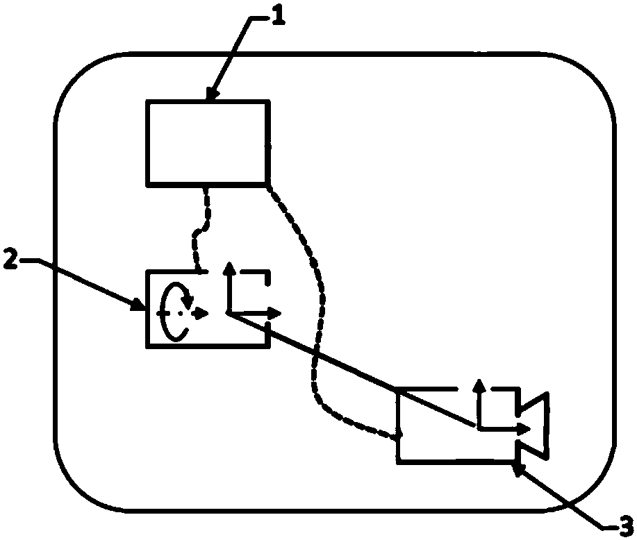
[0100] Such as figure 1 Shown is the hardware architecture schematic diagram of the present invention, is made up of microprocessor (NUC) 1, inertial measurement unit (IMU) 2 and camera 3, and inertial measurement unit (IMU) 2 and camera 3 are all connected with microprocessor (NUC) 1 connected.

[0101] The microprocessor adopts Intel's NUC (NUC5i7RYH) series, and the weight of the whole machine is only 0.607Kg. The processor has the advantages of small size, multiple interfaces, fast processing speed, powerful function, low power consumption, and fast heat dissipation. The main application background of the present invention is the motion pose estimation of the aircraft, and the main algorithm relies on the fast processing of images, so this NUC5i7RYH microprocessor is very suitable for the needs of the present invention.

[0102] The inertial measurement element adopts the LPMS series. This series of products of LP-RESEARCH uses advanced data fusion technology to provide u...


PUM


Abstract

The invention discloses an aircraft pose estimation method based on direct method and inertial navigation integration. The six-degree-of-freedom pose of an aircraft is optimized by visual measurementbased on a direct method, re-projection luminosity errors are minimized, visual measurement is integrated with measurement of inertial navigation components to obtain scales, the aircraft can be accurately positioned for a long time without external aided navigation of GPS (global positioning system) signals and the like, and robustness is good.

Description

technical field [0001] The invention relates to the field of aircraft positioning, in particular to a method for estimating the pose of an aircraft by combining direct methods and inertial navigation. Background technique [0002] Autonomous positioning is the core component of the robot's autonomous navigation system. On the basis of autonomous positioning, the robot can complete more functions, such as obstacle avoidance, path planning, and autonomous navigation. [0003] For the flight control of an unmanned aerial vehicle (UAV, Unmanned Aerial Vehicle), attitude estimation with 6 degrees of freedom is required. When the unmanned aerial vehicle is flying outdoors, the global positioning system (GPS, Global Positioning System) is used, and its accuracy can reach 1cm when the GPS satellites are sufficient. However, when there are building blocks or the aircraft is flying indoors, GPS may not be able to accurately locate or even be used. Another method is to use an inertia...

Claims


Application Information

Patent Timeline
IPC IPC(8): G01C21/16
CPCG01C21/165
Inventor 许超翁一桢
Owner ZHEJIANG UNIV
Why Eureka
Try Eureka