Application method of space remote sensing big data in tropical agriculture calamity calculation

A big data and space technology, applied in special data processing applications, computing, computer components, etc., can solve the problems of inability to complete the survey work in the disaster-stricken area and the high cost of on-site survey work, and achieve the convenience of claim settlement work and save manpower and cost. Effect

Inactive Publication Date: 2018-08-24
中科光启空间信息技术有限公司
View PDF6 Cites 10 Cited by
  • Summary
  • Abstract
  • Description
  • Claims
  • Application Information

AI Technical Summary

Problems solved by technology

When a large area is affected by a disaster, the survey personnel cannot complete the survey work in all the disaster-affected areas within the time limit, and the cost of on-site survey work is too high

Method used


Image

  • Application method of space remote sensing big data in tropical agriculture calamity calculation

Examples


Embodiment Construction

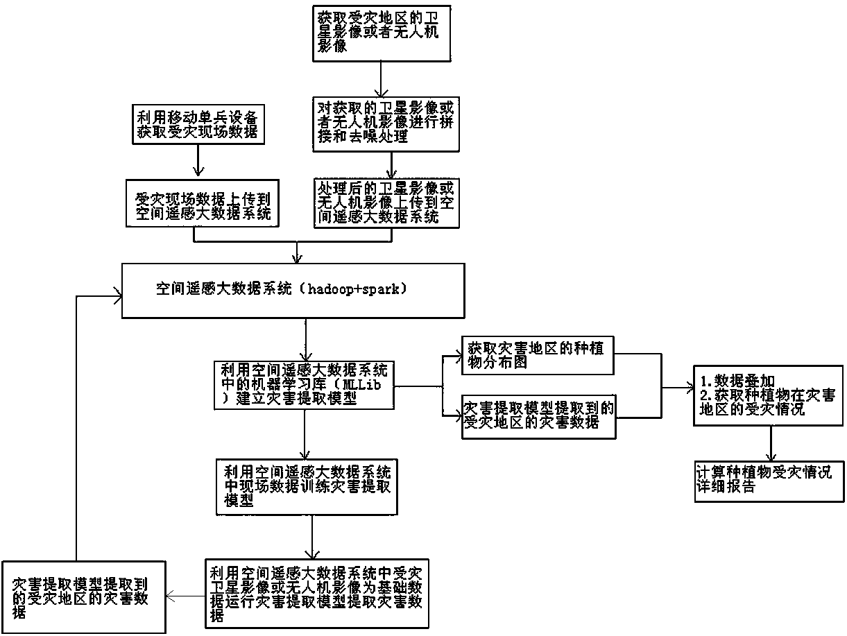
[0015] Such as figure 1 As shown, an application method of space remote sensing big data in tropical agricultural disaster calculation includes the following steps:

[0016] Step 1) Query the latest multi-spectral satellite imagery of the disaster-affected area through the data center. If the required satellite image cannot be obtained, it can be shot on-site by drone to obtain the image of the disaster-affected area in the first time; use the arcmap tool to Image stitching and denoising steps to achieve availability of image data;

[0017] Step 2), ground sampling personnel use arcgis as the interface of mobile individual equipment to conduct on-site sampling in areas with different disaster degrees according to the distribution of the disaster area. The sampling data must have the spatial data of the disaster area and geographical coordinates, and indicate the disaster area of ​​the sample data and degree;

[0018] Step 3), use the high-performance heterogeneous distribute...


PUM


Abstract

The invention relates to application method of space remote sensing big data in tropical agriculture calamity calculation, and specifically relates to the application method that uses space remote sensing big data, considers the geography information system technology, accurately obtains afflicted regions, areas and grades, does not need inspection people to go to each afflicted region, and reduces the investigation works and costs in the tropical agriculture calamity calculation that uses space remote sensing big data. The method comprises the following specific steps: obtaining satellite images or unmanned plane images of the afflicted regions; processing the obtained images, and uploading the data to a space big data system; using a machine learning database in the system to build a calamity extract model; using field data in the system to train the calamity extract model; using the images as basic data to run the calamity extract model, thus extracting calamity data; stacking the data with obtained crop plant distribution maps in the calamity regions, and obtaining the plant afflict conditions of the calamity regions.

Description

technical field [0001] The present invention relates to the application of remote sensing technology and ground information system technology in the monitoring of tropical agricultural disasters, and specifically relates to a method of accurately obtaining the disaster-affected area, disaster-affected area and disaster-affected level through remote sensing big data, combined with geographic information system technology, without the need for surveyors to visit For each disaster-affected area, the application method of spatial remote sensing big data to reduce survey work and survey costs in the calculation of tropical agricultural disasters. Background technique [0002] In the process of tropical agricultural disaster monitoring, the traditional agricultural disaster monitoring is to know that agriculture is affected by disasters through extreme weather or reports from farmers. Surveyors arrive at the scene to start survey work, determine the affected area and affected area...

Claims


Application Information

Patent Timeline
Patent Type & Authority Applications(China)
IPC IPC(8): G06K9/00G06K9/40G06F17/30G06K9/62G06K9/46
CPCG06F16/29G06V20/188G06V10/30G06V10/40G06F18/241G06F18/214
Inventor 蒋鹏飞付连章郑新兴张莉郑克放
Owner 中科光启空间信息技术有限公司
Why Eureka
Try Eureka