ET estimation method for different crops of irrigated area based on canopy air temperature difference and remote sensing information

A technology for crops and irrigation areas, applied in the field of crop ET estimation, can solve problems such as failure to test and apply, and achieve the effect of simplifying the complicated process, improving reliability, and simplifying the model parameters.

Active Publication Date: 2018-08-24
CHINA INST OF WATER RESOURCES & HYDROPOWER RES
View PDF3 Cites 17 Cited by
  • Summary
  • Abstract
  • Description
  • Claims
  • Application Information

AI Technical Summary

Problems solved by technology

Since then, many scholars have used this method to verify and apply it, but they are all at the field scale and have not been tested and applied at a larger scale.

Method used


Image

  • ET estimation method for different crops of irrigated area based on canopy air temperature difference and remote sensing information
  • ET estimation method for different crops of irrigated area based on canopy air temperature difference and remote sensing information
  • ET estimation method for different crops of irrigated area based on canopy air temperature difference and remote sensing information

Examples


Embodiment Construction

[0018] The present invention will be described in detail below in conjunction with the accompanying drawings and embodiments.

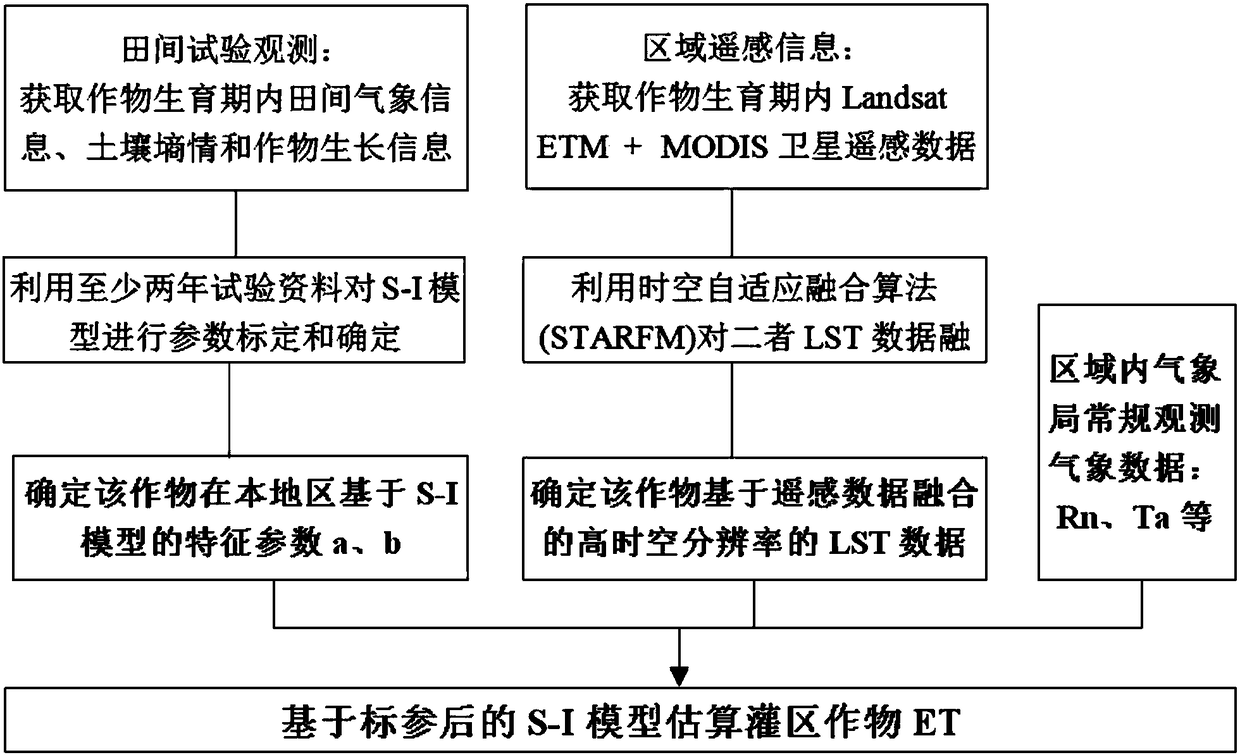
[0019] Such as figure 1 As shown, the present invention provides a method for estimating the evaporation (ET) of different crops in irrigation areas based on canopy air temperature difference and remote sensing information, which may further comprise the steps:

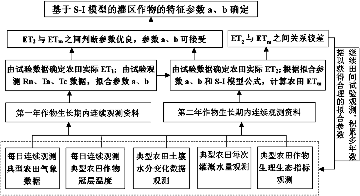
[0020] 1) Based on at least two years of typical farmland detailed experimental historical observation data, the characteristic parameters a and b of the S-I model are calibrated and determined to obtain a reliable and accurate calibrated S-I model;

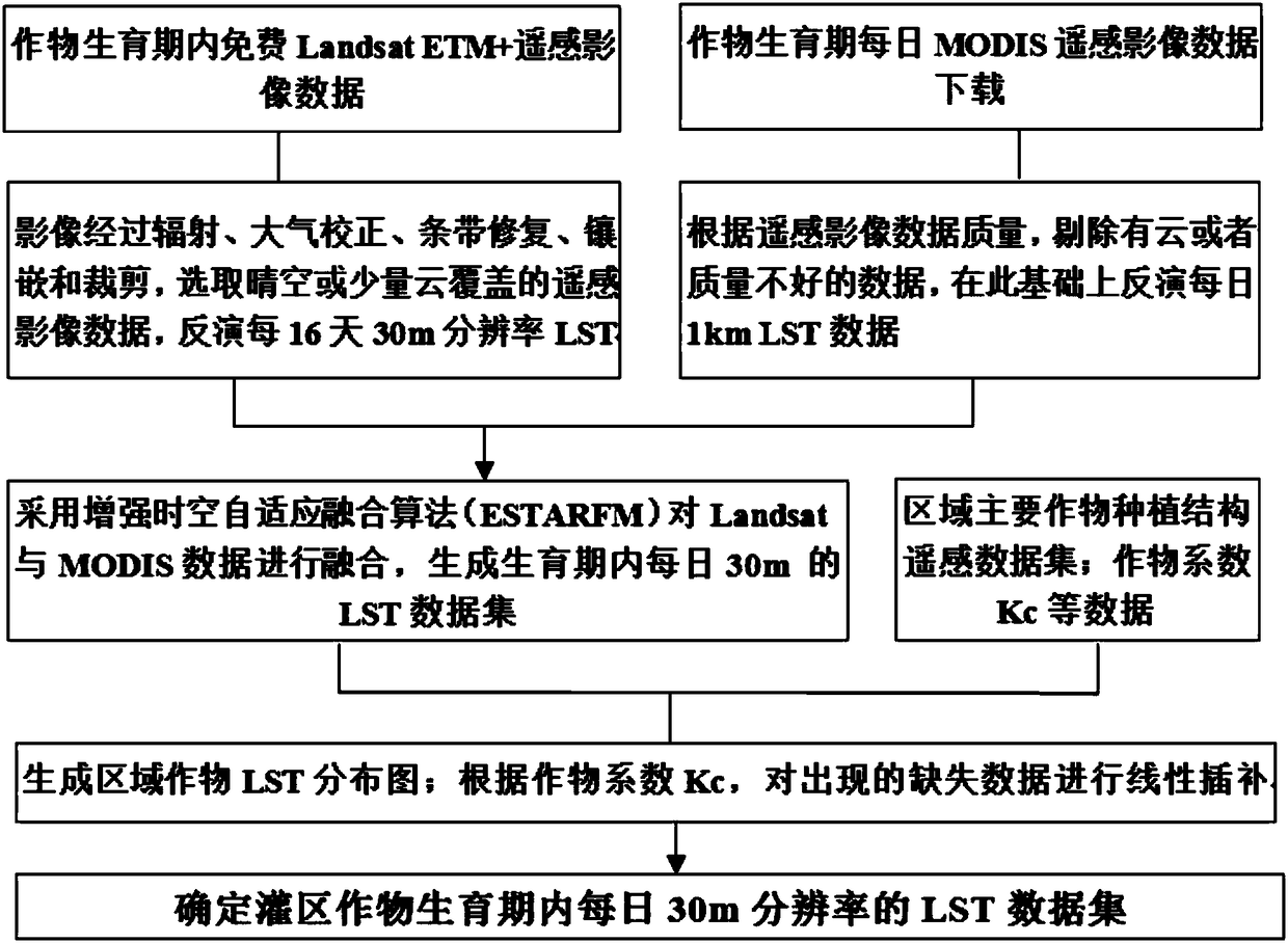
[0021] 2) Using Landsat8 (NASA’s Landsat satellite) and MODIS (Moderate Resolution Imaging Spectrometer on EOS Satellite) remote sensing image data during the crop growth period in the irrigated area, using the enhanced spatiotemporal adaptive fusion algorithm (ESTARFM) to fuse Landsat8 and MODIS data, Obtain the LST (Land Surface Temperature) ...


PUM


Abstract

The invention relates to an ET estimation method for different crops of an irrigated area based on canopy air temperature difference and remote sensing information. The method comprises the steps thatcalibration and determination of characteristic parameters a and b are performed on an S-I model according to at least two years of typical detailed farmland test historical observation data so as toacquire a reliable and accurate calibrated S-I model; the Landsat7 and MODIS data are fused by using an enhanced space-time adaptive fusion algorithm by using the Landsat and MODIS remote sensing image data within the irrigated area crop growth period so as to obtain the LST data set of 30m spatial resolution per day within the irrigated area crop growth period; the LST is the surface temperature; and the distribution of the area farm net radiation Rn and the air temperature Ta is acquired through combination of the conventional observation data from the local weather bureau, and the area crop ET is estimated by using the calibrated S-I model on the basis of the LST data set of high spatial resolution. The area crop ET can be rapidly and accurately estimated so as to provide the timely and accurate data for agricultural irrigation management of the irrigated area.

Description

technical field [0001] The invention relates to a method for estimating crop ET, in particular to a method for estimating ET (evapotranspiration) of different crops in an irrigation area based on canopy temperature difference and remote sensing information. Background technique [0002] With the acceleration of the urbanization process in our country, the rural labor force gradually transfers to the secondary and tertiary industries in the city; the large loss of rural labor force makes it difficult to continue the traditional agricultural management mode of one household, and the intensive agricultural management has become an inevitable trend of modern agricultural development. Agricultural irrigation has gradually shifted from single, fragmented and small farmlands to contiguous, large farms. China is a country seriously short of water resources, and the contradiction between supply and demand of water resources is still the main bottleneck of sustainable development, and...

Claims


Application Information

Patent Timeline
Patent Type & Authority Applications(China)
IPC IPC(8): G06Q50/02G06K9/62G06F17/50
CPCG06Q50/02G06F30/20G06F18/251
Inventor 蔡甲冰李益农陈鹤魏征张宝忠许迪龚时宏彭致功
Owner CHINA INST OF WATER RESOURCES & HYDROPOWER RES
Why Eureka
Try Eureka