Method for extracting tree heights by aid of unmanned aerial vehicles and ground-based laser radar combined with same

A technology of laser radar and unmanned aerial vehicles, which is applied to the re-radiation of electromagnetic waves, radio wave measurement systems, and the use of re-radiation, etc., can solve the problems of undetailed description of the vertical structure of the lower layer, poor estimation effect, and high data costs, etc., to achieve Reduce the consumption of manpower and material resources, save costs and improve efficiency

Inactive Publication Date: 2018-09-28
NANJING FORESTRY UNIV
View PDF5 Cites 18 Cited by
  • Summary
  • Abstract
  • Description
  • Claims
  • Application Information

AI Technical Summary

Problems solved by technology

In the past, point clouds were obtained by aerial laser scanners (ALS) to achieve accurate descriptions of tree canopies and topography. However, the cost of airborne data acquisition is high, especially for the lack of detailed description of the vertical structure of the forest canopy
[0003] Tree height estimation, especially individual tree height extraction, is an important part of forest resources survey. With the development of remote sensing technology, traditional manual ground surveys are gradually replaced by new methods due to the consumption of a lot of manpower and material resources. The efficiency and accuracy of survey work It has also been improved. At present, the research on tree height extraction using ground-based lidar is relatively common. Li Dan et al. published "Research on Single Tree DBH and Tree Height Extraction Based on TLS Data" in "Journal of Beijing Forestry University" 2012 No. 4 , based on ground-based laser radar scanning point cloud data to study the tree height of birch natural forest in Xiaoxing'an Mountains, the results show that the root mean square error of tree heights in 5 multi-station scanning sample plots is compared with the measured data, and the root mean square error is within 5m. Common phenomenon of tree height underestimation
Liu Luxia and others published "Extraction of DBH and height of single tree in subtropical forest based on ground-based lidar" in "Journal of Remote Sensing" No. 2, 2016. The height of single tree in subtropical forest was extracted based on TLS data. The results showed that single tree in natural forest Estimated R ~ 2 = 0.77, estimated R ~ 2 = 0.94 for a single tree in a plantation, the research has a high estimation accuracy for plantations with regular stem shapes and stands with low canopy density, and for forests with large canopy density Area estimates are poor
In addition, there is a stereo image pair method based on aerial photogrammetry to estimate tree height. Fan Jiangchuan published "Research on UAV Aerial Photography Tree Measurement Technology" in "Beijing Forestry University" in 2014, using the stereo image pair method to estimate tree height. The overall accuracy reached 93.67%, but this method generally requires manual picking of treetops and tree root points, and the work efficiency of tree height extraction for large-scale forest stands is too low
Wang Wei published "UAV Image Forest Information Extraction and Model Development" in "Beijing Forestry University" in 2015, using DSM and DOM data with 0.1m precision to analyze the height of individual trees in forest stands under different canopy density The extraction experiment was carried out, and the results showed that the correlation coefficient between the extracted value of tree height and the measured value was 0.752, but it was difficult to extract the forest with high canopy density

Method used


Image

  • Method for extracting tree heights by aid of unmanned aerial vehicles and ground-based laser radar combined with same
  • Method for extracting tree heights by aid of unmanned aerial vehicles and ground-based laser radar combined with same
  • Method for extracting tree heights by aid of unmanned aerial vehicles and ground-based laser radar combined with same

Examples


Embodiment 1

[0028] A method for extracting tree height by combining UAV and ground-based lidar, comprising the following steps:

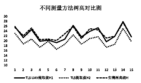
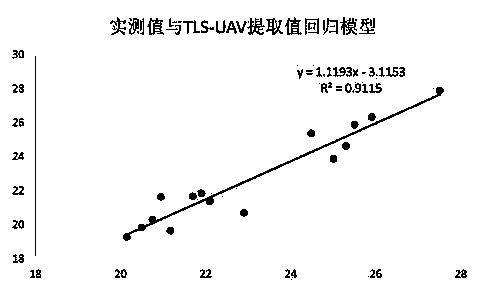
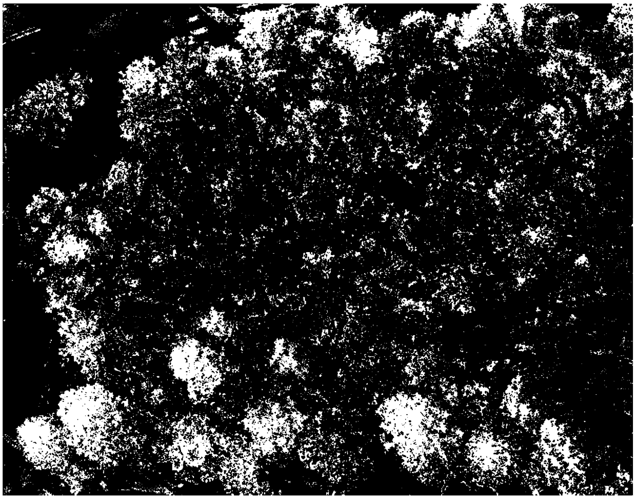
[0029] (1) The Riegl VZ-400i LiDAR sensor is used to obtain the LiDAR point cloud data in the area to be detected, and the sensor records the complete laser pulse return waveform information. Specifically, the point cloud data has position and color information. The color information is obtained through the camera to obtain a color image, and then the color information of the pixel at the corresponding position is assigned to the corresponding point in the point cloud. The intensity information is acquired by the laser scanner receiving device. Echo intensity, including multiple waveform information of the first echo, second echo and multiple echoes, see the ground-based lidar scanning point cloud figure 1 ;

[0030] (2) Use the DJI multi-rotor UAV Phantom4PRO to obtain high-resolution two-dimensional image data at a height of 90m in the area to be inspected; ...


PUM


Abstract

The invention discloses a method for extracting tree heights by the aid of unmanned aerial vehicles and ground-based laser radar combined with the same, and belongs to the technical field of forest resource dynamic monitoring. The method includes acquiring point cloud data of forest surface layers from two-dimensional images of the unmanned aerial vehicles; acquiring point cloud data of crown canopy lower layers by the aid of ground-base laser scanners; introducing real-time kinematic (RTK) data; registering the point cloud data of the forest surface layers and the point cloud data of the crown canopy lower layers to obtain metasequoia glyptostroboides tree height information in the same coordinate reference system. The method has the advantages that respective merits of the data from twodifferent sources can be complemented by one another, and accordingly the tree height acquisition precision can be improved under the condition of high crown density of tall arbors; manual ground survey can be replaced with the method to a certain extent, accordingly, the cost can be saved, and the efficiency can be improved.

Description

technical field [0001] The invention belongs to the technical field of dynamic monitoring of forest resources, and more specifically relates to a method for extracting tree heights by combining unmanned aerial vehicle and ground-based laser radar. Background technique [0002] From the perspective of ecology, economy and society, forest is an important resource, and fully understanding the shape and distribution of forest trees has great significance for forest protection and management. In the past, point clouds were obtained by aerial laser scanners (ALS) to achieve accurate descriptions of tree canopies and topography. However, airborne acquisition of data is expensive, especially for the lack of detailed description of the vertical structure of the forest canopy. [0003] Tree height estimation, especially individual tree height extraction, is an important part of forest resources survey. With the development of remote sensing technology, traditional manual ground survey...

Claims


Application Information

Patent Timeline
Patent Type & Authority Applications(China)
IPC IPC(8): G01S17/89
CPCG01S17/89
Inventor 代婷婷田佳榕徐雁南
Owner NANJING FORESTRY UNIV
Why Eureka
Try Eureka