Subway subgrade structure monitoring method and device based on foundation InSAR

A structure monitoring and ground-based technology, applied in measuring devices, radio wave measurement systems, radio wave reflection/re-radiation, etc., can solve problems such as difficult implementation, large influence of temperature equipment, difficult real-time monitoring all day long, etc., to achieve Overcome the effects of heavy workload, wide coverage and high measurement accuracy

Inactive Publication Date: 2018-10-09
BEIJING URBAN CONSTR EXPLORATION & SURVEYING DESIGN RES INST
View PDF4 Cites 31 Cited by
  • Summary
  • Abstract
  • Description
  • Claims
  • Application Information

AI Technical Summary

Problems solved by technology

[0005] (1) The measurement method of traditional subway elevated and subgrade structures is discrete, and can only reflect the overall deformation of the structure through point data;
[0006] (2) The measurement methods of the traditional subway elevated and subgrade structures are affected by the surrounding environment and their own characteristics, so long-distance monitoring cannot be carried out. The longest monitoring distance is about 300m, which cannot meet the monitoring requirements under special conditions;
[0007] (3) The traditional measurement methods of traditional subway elevated and subgrade structures are difficult to achieve all-day real-time

Method used


Image

  • Subway subgrade structure monitoring method and device based on foundation InSAR
  • Subway subgrade structure monitoring method and device based on foundation InSAR
  • Subway subgrade structure monitoring method and device based on foundation InSAR

Examples


Embodiment Construction

[0042] The following will clearly and completely describe the technical solutions in the embodiments of the present invention with reference to the accompanying drawings in the embodiments of the present invention. Obviously, the described embodiments are only some, not all, embodiments of the present invention. Based on the embodiments of the present invention, all other embodiments obtained by persons of ordinary skill in the art without making creative efforts belong to the protection scope of the present invention.

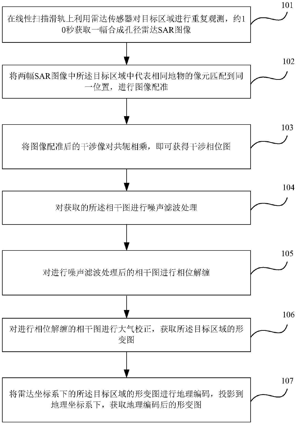
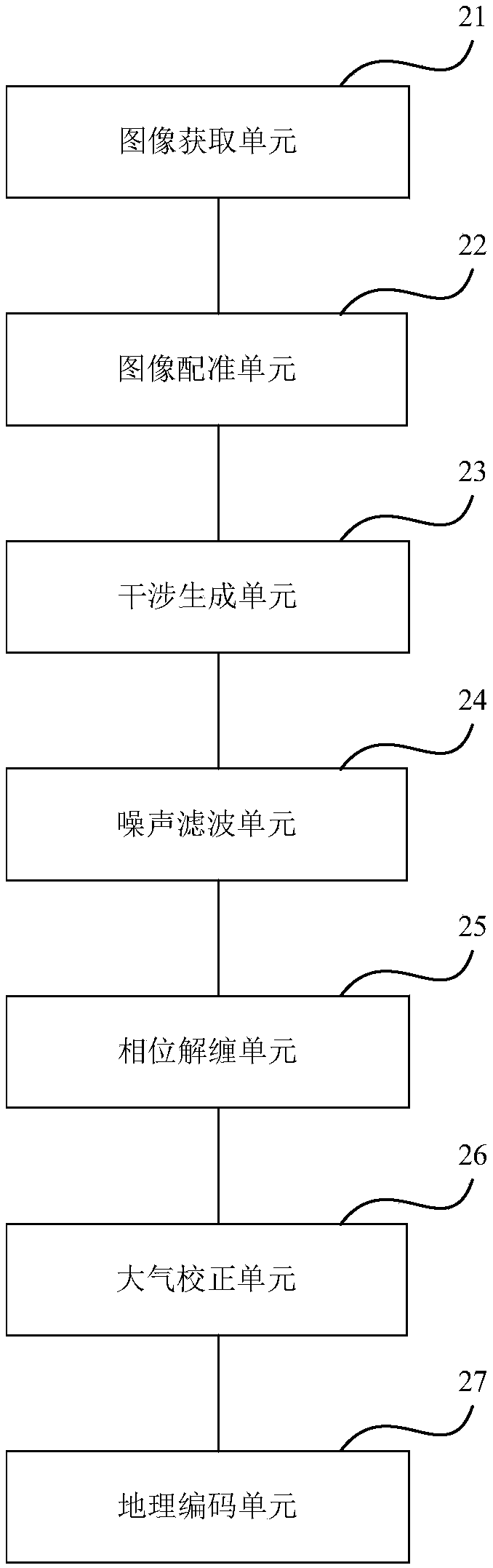
[0043] Such as figure 1 As shown, it is a flowchart of a ground-based InSAR-based subway subgrade structure monitoring method according to an embodiment of the present invention, and the method includes:

[0044] 101. Use the radar sensor to repeatedly observe the target area on the linear scanning slide rail, and obtain a synthetic aperture radar SAR image in about 10 seconds;

[0045] 102. Match the pixels representing the same ground object in the target a...


PUM


Abstract

The embodiment of the invention provides a subway subgrade structure monitoring method and device based on foundation InSAR. The method comprises the steps of using a radar sensor for repeatedly observing a target area on a linear scanning slide rail, and obtaining a synthetic aperture radar SAR image in about 10 seconds; matching image elements representing the same object in the target region inthe two SAR images to the same position, carrying out image registration; subjecting an interference image pair after image registration to conjugate multiplication (as shown in the description) to obtain an interference phase graph; carrying out noise filtering processing on the obtained coherent graph gamma; carrying out phase unwrapping on the coherent graph gamma subjected to noise filteringprocessing; carrying out atmospheric correction on the coherent image gamma subjected to phase unwrapping to obtain a deformation graph of the target area; carrying out geocoding on the deformation graph of the target area under the radar coordinate system, projecting to the geographic coordinate system, and obtaining a geographic coded deformation graph. High-precision and continuous deformationmonitoring of the whole area of the subway elevated and roadbed structure can be implemented under the extreme weather conditions or long distances (4Km) range.

Description

technical field [0001] The invention relates to the field of engineering measurement, in particular to a method and device for monitoring a subway foundation structure based on foundation InSAR. Background technique [0002] It is necessary to monitor the deformation of the subway structure during the construction of crossing and adjacent subway elevated and subgrade projects, so as to timely understand the structural deformation of the existing subway and ensure the safety of the existing subway structure and train operation. [0003] During the operation of the train, in order to ensure the safe operation of the train, it is necessary to timely understand the deformation of the subway structure within the scope of construction influence. The non-contact remote automatic monitoring system can meet the deformation monitoring problem during the operation of the train. The current automatic monitoring system mainly uses the static level system and the measuring robot system. ...

Claims


Application Information

Patent Timeline
IPC IPC(8): G01S13/90
CPCG01S13/90G01S13/9023
Inventor 陈林王思锴刘君伟王志京陈维桢范静雅石磊任雪峰
Owner BEIJING URBAN CONSTR EXPLORATION & SURVEYING DESIGN RES INST
Why Eureka
Try Eureka