
Navigation system for underwater bathyscaph and precise three-point positioning method

A navigation system and submersible technology, which is applied to the navigation system of underwater submersibles and the field of precise three-point positioning, can solve the problems of poor GPS maneuverability, difficult GPS high-performance main navigation system, no reports, etc. Achieve strong environmental adaptability, simple positioning method, and good portability

Active Publication Date: 2018-10-23
HOHAI UNIV
View PDF1 Cites 10 Cited by
  • Summary
  • Abstract
  • Description
  • Claims
  • Application Information

AI Technical Summary

Problems solved by technology

Therefore, when the receiver antenna is blocked by obstacles such as buildings and leaves or in deep sea conditions, the number of visible satellites is difficult to meet the requirements
Due to the structural characteristics of the GPS receiver tracking loop, the GPS maneuverability is poor
The complexity of GPS navigation calculation makes the update frequency of receiver navigation information only a few hertz, which makes it difficult to meet the requirements for the output frequency of navigation information under special conditions
The above characteristics make it difficult for GPS to be used as a high-performance primary navigation system. In many cases, GPS is used as an auxiliary system for the primary navigation system.
[0005] The integrated navigation system based on inertial navigation and integrated with GPS and electronic compass has a large number of applications in land, aviation, aerospace and surface carriers at home and abroad, but underwater submersibles work for a long time in the deep sea, and GPS information is in Underwater cannot be used, single inertial navigation cannot meet the positioning requirements, and because underwater deep submersibles have high requirements for power consumption, volume and accuracy, the integrated navigation system of underwater deep submersibles has not been well applied
[0006] How to make full use of the advantages of electronic compass, extremely low frequency electromagnetic wave, GPS, and strapdown inertial integrated navigation system to meet the requirements of high precision and long flight time will be a relatively difficult problem, and this system is widely used at home and abroad. None reported

Method used


Image

  • Navigation system for underwater bathyscaph and precise three-point positioning method
  • Navigation system for underwater bathyscaph and precise three-point positioning method
  • Navigation system for underwater bathyscaph and precise three-point positioning method

Examples


Embodiment Construction

[0028] The present invention will be further described below in conjunction with the accompanying drawings and specific embodiments.

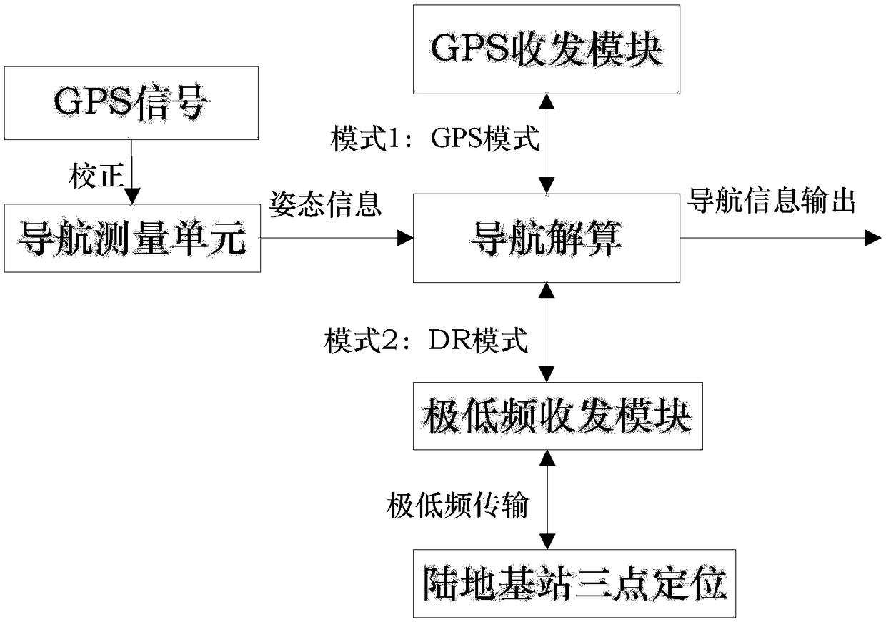
[0029] The navigation system for underwater deep submersibles, in order to improve the accuracy, stability and low power consumption of underwater deep submersible autonomous navigation, the present invention improves the design from the information receiving mode of integrated navigation, and uses low-frequency electromagnetic waves to transmit deep Submersible navigation information. The navigation system for underwater deep submersibles includes a global positioning system GPS transceiver module, an extremely low frequency transceiver module, a navigation measurement unit, a digital signal processing (DSP) unit, and a deep submersible central computer. The navigation measurement unit includes micro-electromechanical inertial measurement unit (MEMS IMU) and electronic compass; the GPS transceiver module, the extremely low frequency transceive...


PUM


Abstract

The invention discloses a navigation system for an underwater bathyscaph and a precise three-point positioning method. The navigation system comprises an extremely low frequency receiving and transmitting module, a GPS receiving and transmitting module, an electronic compass, a digital signal processing unit, an MEMS inertia measurement unit and a bathyscaph center computer. According to the invention, an MEMS gyroscope and an MEMS accelerometer are employed for forming a posture measurement unit, and form an inertial combination navigation positioning system with the electronic compass, and the inertial combination navigation positioning system cooperate with a control system. When the bathyscaph is located on a water surface, the bathyscaph is switched to a GPS mode, and obtains the position information through the GPS receiving and transmitting module; when the bathyscaph is located underwater, the GPS positioning data is invalid or DOP increases to a pre-determined threshold value,the bathyscaph is switched to a dead reckoning mode, and is located via a three-point positioning method of four extremely low frequency land base stations through combining with the characteristicsof extremely low frequency electromagnetic waves in a deep sea.

Description

technical field [0001] The invention belongs to the field of underwater positioning and navigation, and in particular relates to a navigation system for underwater deep submersibles and a precise three-point positioning method. The device has the characteristics of low power consumption and high precision, and can realize underwater deep submersible precise positioning. Background technique [0002] Research in recent years has found that extremely low-frequency electromagnetic waves (0.1-30-300Hz) have better penetration in deep seas. The lower the frequency of electromagnetic waves, the greater the skin depth, and the easier it is to penetrate seawater and propagate downward. Ocean internal waves should try to use low-frequency bands. [0003] Electronic compass can be divided into three-dimensional electronic compass and planar electronic compass. Compared with the planar compass, the three-dimensional electronic compass overcomes the strict limitation of planar electron...

Claims


Application Information

Patent Timeline
IPC IPC(8): G01S19/42G01C17/32G01C19/00
CPCG01C17/32G01C19/00G01S19/42
Inventor 黄浩乾黄铁卢新彪周军刘志强甘磊
Owner HOHAI UNIV
Learn More