Method for detecting ship target position at submarine cable zone

A technology of target position and detection method, applied in radio wave measurement systems, instruments, etc., can solve problems such as large deviation and inability to provide target coordinates, and achieve the effect of correcting system errors, reducing sea clutter interference, and avoiding drift.

Inactive Publication Date: 2018-11-16
STATE GRID FUJIAN ELECTRIC POWER CO LTD +1
View PDF4 Cites 18 Cited by
  • Summary
  • Abstract
  • Description
  • Claims
  • Application Information

AI Technical Summary

Problems solved by technology

However, there is a large deviation between the target position detected by a single radar

Method used


Image

  • Method for detecting ship target position at submarine cable zone
  • Method for detecting ship target position at submarine cable zone
  • Method for detecting ship target position at submarine cable zone

Examples


Embodiment Construction

[0048] The following will clearly and completely describe the technical solutions in the embodiments of the present invention with reference to the accompanying drawings in the embodiments of the present invention. Obviously, the described embodiments are only some, not all, embodiments of the present invention. Based on the embodiments of the present invention, all other embodiments obtained by persons of ordinary skill in the art without making creative efforts belong to the protection scope of the present invention.

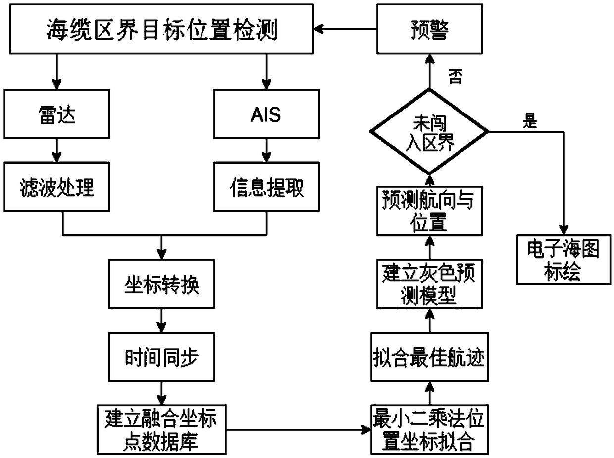
[0049] see figure 1 As shown, a method for detecting the target position of a submarine cable boundary ship includes:

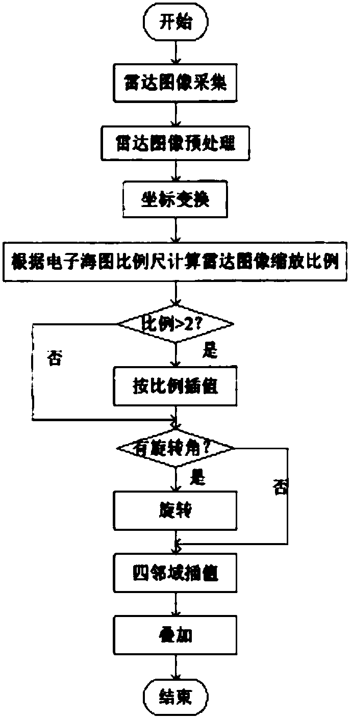
[0050] (a) performing positioning detection by shore-based radar, obtaining radar target position data, and obtaining a radar map plotted with surrounding geographical conditions; the radar target position data includes ship course information and polar coordinate position information;

[0051] (b) receiving AIS target position data through ...


PUM


Abstract

The invention relates to a method for detecting a ship target position at a submarine cable zone, in particular to a data fusion position detection algorithm based on a radar target recognition technology and a shore-based ship automatic identification system. The method comprises firstly plotting a surrounding geographical situation on a radar chart by using shore-based radar position detection;confirming a dynamic target by filtering; tracking a heading and a polar coordinate position; fusing with target position information by time synchronization; correcting a radar-plotted target position by the ship position information received by a B-type shore-based AIS; predicting the heading and the speed of the ship at the next moment by target position detection; finally obtaining the real geographical position of the target; superposing the radar chart on an electronic chart, and drawing a submarine cable zone by using an electronic auxiliary navigation mark to ensure the safety of the submarine cable zone. The method, by using the instantaneity of the AIS position information and in combination with radar data comparison fusion, reduces the displacement error of a radar-positioned sea surface target, and achieves an accurate position detection result.

Description

technical field [0001] The invention relates to the technical fields of radar target detection, ship automatic identification system (AIS), electronic chart system (ECDIS) and computer graphic processing, in particular to a method for detecting the position of a ship target at the boundary of a submarine cable. Background technique [0002] The ship automatic identification system (AIS) technology cooperates with the global positioning system (GPS) to combine ship dynamics such as ship position, ship speed, rate of change of course and course with static ship information such as ship name and call sign from the VHF channel to ships in nearby waters And shore station broadcasting, so that neighboring ships and shore stations can timely grasp the dynamic and static information of all ships on the nearby sea surface, and obtain the ship's position coordinates to avoid in time. [0003] The radar emits electromagnetic wave energy to a certain direction in space, and objects in t...

Claims


Application Information

Patent Timeline
IPC IPC(8): G01S7/41
CPCG01S7/41
Inventor 杨祖培徐丽红陈奇太唐泉彬潘文庆许奕平黄咏王乘恩
Owner STATE GRID FUJIAN ELECTRIC POWER CO LTD
Why Eureka
Try Eureka