Non-motor vehicle lane planning method based on non-motor vehicle route data

A non-motor vehicle lane and non-motor vehicle technology, which is applied in the field of non-motor vehicle lane planning based on non-motor vehicle route data, can solve the problem of lack of grasping means, lack of data basis, and lack of targeted data support for actual driving conditions of non-motor vehicles. and other issues, to achieve the effect of strong practicability, strong pertinence, rapid and flexible data update

Active Publication Date: 2018-12-25
SHANGHAI URBAN CONSTR DESIGN RES INST GRP CO LTD
View PDF2 Cites 1 Cited by
  • Summary
  • Abstract
  • Description
  • Claims
  • Application Information

AI Technical Summary

Problems solved by technology

[0003] However, in the past, there was no effective means of grasping the actual situation of non-motor vehicle operation, such as the number of non-motor vehicles, driving routes, driving behavior and other data have not been effectively monitored, adopted and utilized
This has led to the lack of data support for the grasp of non-motor vehicle demand and the current driving environment. The planning of non-motor vehicle network and the improvement of non-motor vehicle lanes lack the pertinence of the actual driving conditions of non-motor vehicles and the rationality of data support. sex

Method used


Image

  • Non-motor vehicle lane planning method based on non-motor vehicle route data
  • Non-motor vehicle lane planning method based on non-motor vehicle route data
  • Non-motor vehicle lane planning method based on non-motor vehicle route data

Examples


Embodiment 1

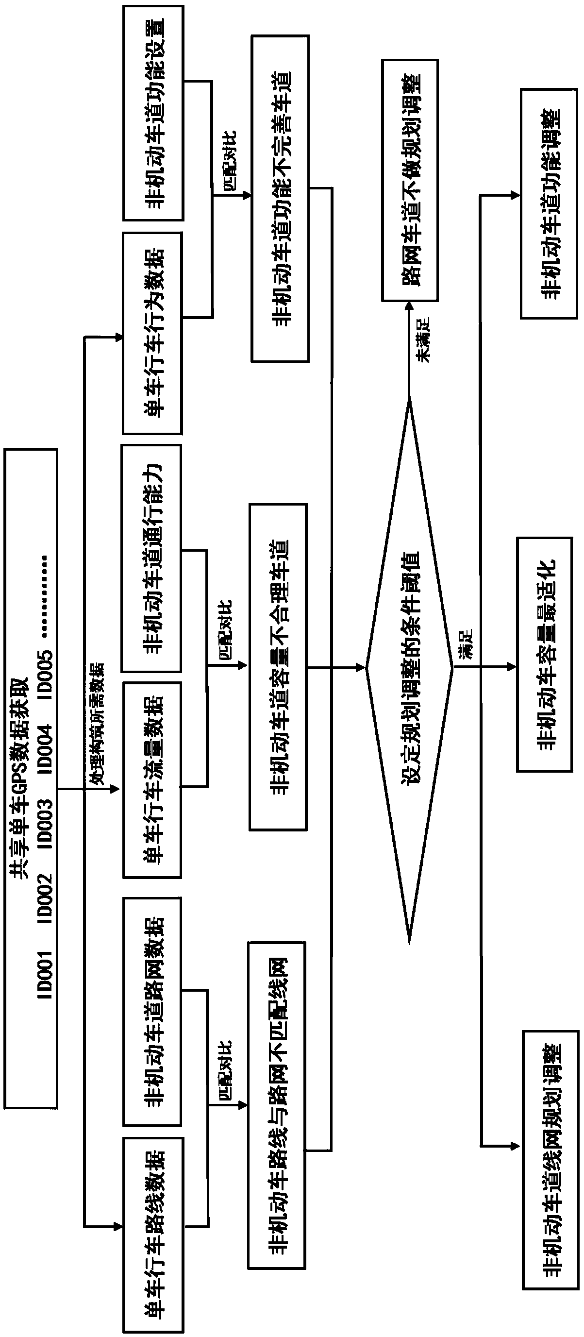
[0051] Such as figure 1 As shown, the non-motor vehicle lane planning method based on non-motor vehicle route data; the steps are as follows:

[0052] a. Obtain the GPS data and vehicle ID data of all bicycles from the shared bicycle platform, and construct the bicycle driving route data, bicycle traffic data and bicycle driving behavior data of each bicycle;

[0053] b. Matching and comparing the bicycle route data with the non-motor vehicle road network data to obtain a non-motor vehicle road network that does not match the non-motor vehicle route;

[0054] Matching and comparing the single-vehicle traffic flow data with the traffic capacity of the non-motor vehicle lane, and obtaining a lane with an unreasonable capacity of the non-motor vehicle lane;

[0055] Said matching and comparing the single-vehicle driving behavior data with the non-motor vehicle lane function settings, and obtaining the non-motor vehicle lane function imperfect lane;

[0056]c. Set the conditiona...

Embodiment 2

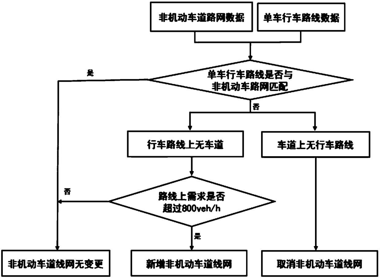
[0061] Such as Figure 2 to Figure 4 As shown, the comparative analysis of non-motor vehicle road network paths: By comparing the planned or current planned non-motor vehicle road network and the difference between the network formed by bicycle routes, the non-motor vehicle lane network planning is adjusted. The traffic capacity of a non-motorized lane is generally 800-1200veh / h, then it is assumed that the non-motorized vehicle road network does not match the route and the demand for non-motorized vehicles on the road section exceeds 80% of the traffic capacity of a non-motorized lane (ie 800veh / h) The plan of adding non-motorized lanes may be considered.

Embodiment 3

[0063] Such as Figure 5 As shown, non-motorized lane capacity optimization: By comparing the matching degree of actual flow with non-motorized lane capacity and the behavioral demands of non-motorized vehicles, the current or planned non-motorized lane width and related functions are adjusted and optimized. The design of non-motor vehicle lanes should adopt the three-level service level standard, and the load degree should be controlled between 0.70 and 0.85, and those exceeding or falling below this range should be adjusted proportionally. For example, when the load degree is 0.6, it is 0.1 smaller than the minimum value of the set range of 0.7, and the width of a lane is reduced by 0.1 (that is, 0.1m). Such as Figure 11 , Figure 12 , Figure 13 As shown, it can also be adjusted in conjunction with non-motor vehicle separation facilities (addition of non-motor vehicle separation facilities can increase the traffic capacity of non-motorized lanes by 10% to 20%).

[0064...


PUM


Abstract

The invention discloses a non-motor vehicle lane planning method based on non-motor vehicle route data. The main steps are as follows: acquiring GPS data and vehicle ID data from shared bicycles to construct the route, behavior and flow data of each bicycle; Then superposing and comparing these data with the geospatial data of the current situation or the planned non-motor vehicle road network andthe functional form of the lane conditions, from which the problems of the current situation or the planning scheme can be found and improved. The non-motor vehicle lane planning method provides a bottom-up new method for pertinently carrying out road network planning, scheme comparison and selection, lane capacity function improvement and the like according to the driving characteristics of non-motor vehicles in a specific city, a specific area and even a specific lane by matching and comparing the data obtained by the shared bicycle with the current geospatial data.

Description

technical field [0001] The invention relates to the technical field of traffic road construction, in particular to a non-motor vehicle lane planning method based on non-motor vehicle route data. Background technique [0002] As the number of motor vehicles in our country continues to increase, traffic problems such as urban congestion and pollution are becoming more and more serious. Reasonably improving the urban public transportation system as a countermeasure has been widely recognized and implemented. Among them, bicycles, as a short-distance point-to-point transportation mode, can supplement the peripheral demand of urban public transportation and effectively solve the last mile problem in my country's public transportation system. [0003] However, in the past, there was no effective way to grasp the actual situation of non-motor vehicle operation, such as the number of non-motor vehicles, traffic routes, traffic behavior and other data have no effective monitoring, ad...

Claims


Application Information

Patent Timeline
Patent Type & Authority Applications(China)
IPC IPC(8): E01C1/00
CPCE01C1/002
Inventor 彭庆艳王啸君毛峰王维凤陈锦秀
Owner SHANGHAI URBAN CONSTR DESIGN RES INST GRP CO LTD
Why Eureka
Try Eureka