Node deployment and positioning method for patrol inspection of unmanned aerial vehicles in ecological environment

A positioning method and node deployment technology, which can be applied to services based on specific environments, satellite radio beacon positioning systems, services based on location information, etc., and can solve the problems of limited hardware cost and power consumption, and low positioning accuracy. To achieve the effect of saving cost and power consumption, high positioning accuracy and strong maneuverability

Inactive Publication Date: 2019-01-04
上海亦琰信息科技有限公司
View PDF1 Cites 5 Cited by
  • Summary
  • Abstract
  • Description
  • Claims
  • Application Information

AI Technical Summary

Problems solved by technology

Although the positioning mechanism based on ranging can obtain better positioning accuracy in general, it will be limited by hardware cost and power consumption; although the non-ranging positioning method is a low-cost solution, its positioning accuracy is low. distance-based positioning method
Most of the existing positioning algorithms are based

Method used


Image

  • Node deployment and positioning method for patrol inspection of unmanned aerial vehicles in ecological environment
  • Node deployment and positioning method for patrol inspection of unmanned aerial vehicles in ecological environment
  • Node deployment and positioning method for patrol inspection of unmanned aerial vehicles in ecological environment

Examples


Example Embodiment

[0030] A node deployment and positioning method for drone inspection in ecological environment includes:

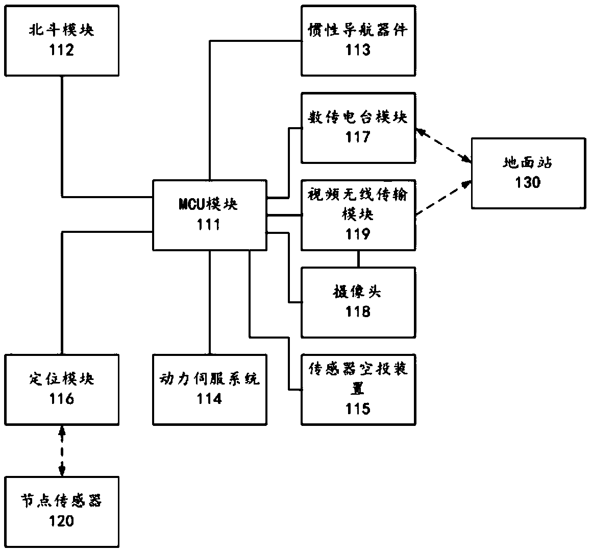
[0031] 1. The UAV 110 navigates through the navigation system, and airdrops multiple node sensors 120 to corresponding preset airdrop areas.

[0032] 2. Using the quadrilateral measurement method, the UAV 110 itself is used as the anchor node to locate each node sensor 120 of the airdrop:

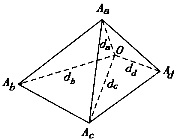
[0033] 1. The UAV navigates through the navigation system and flies to four different positions as four anchor nodes. The four anchor nodes are not coplanar, and the coordinates of the four are A respectively. a (x a ,y a ,z a ), A b (x b ,y b ,z b ), A c (x c ,y c ,z c ) And A d (x d ,y d ,z d ), see figure 2 , O in the figure represents the node sensor, and the coordinates of the anchor node are provided by the Beidou positioning system;

[0034] 2. Detect the distance d between the anchor node and the node sensor 120 a ,d b ,d c And d d , The traditional TOA algorithm has relatively high re...


PUM


Abstract

The invention relates to a node deployment and positioning method for patrol inspection of an unmanned aerial vehicle (UAV) in an ecological environment, which comprises the following steps: airdropping a plurality of node sensors to a corresponding preset airdrop area respectively by the unmanned aerial vehicle through navigation system navigation; and positioning each node sensor which is airdropped through using the unmanned aerial vehicle as an anchor node. The method has high positioning accuracy, and the formed wireless sensor network does not require to re-set the anchor node and carryout positioning, thus saving cost and power consumption.

Description

technical field [0001] The invention belongs to the technical field of unmanned aerial vehicle inspection, and in particular relates to a node deployment and positioning method for ecological environment unmanned aerial vehicle inspection. Background technique [0002] UAV is a powered, controllable, unmanned aerial vehicle that can carry multiple mission equipment, perform multiple tasks, and can be reused. It has many advantages such as low cost, low loss, reusability and low risk. ,with broadly application foreground. In recent years, the application of UAVs in environmental monitoring is generally divided into three categories. The first category uses drones for low-altitude remote sensing to perceive environmental changes, the second category directly installs special sensors on drones to realize environmental perception, and the third category uses drones to airdrop measurement equipment. [0003] There are already many algorithms for the above three types of researc...

Claims


Application Information

Patent Timeline
IPC IPC(8): H04W4/02H04W4/021H04W4/024H04W4/40G01C15/02G01C21/16G01S19/47H04B7/185
CPCG01C15/02G01C21/165G01S19/47H04B7/18506H04W4/021H04W4/023H04W4/024H04W4/40
Inventor 于修和施登宇于梓洋
Owner 上海亦琰信息科技有限公司
Why Eureka
Try Eureka