
Evapotranspiration remote sensing inversion method and application based on two-dimensional space of reflectivity-vegetation coverage

A technology for remote sensing of vegetation coverage and evapotranspiration, which can be used in the measurement of scattering characteristics, measurement devices, and material analysis by optical means, which can solve problems such as limited applications.

Active Publication Date: 2019-01-11
INST OF GEOGRAPHICAL SCI & NATURAL RESOURCE RES CAS +1
View PDF6 Cites 10 Cited by
  • Summary
  • Abstract
  • Description
  • Claims
  • Application Information

AI Technical Summary

Problems solved by technology

However, the traditional triangular / trapezoidal model of land surface temperature-vegetation index has the following limitations: (1) It requires matching data of visible light and thermal infrared, which directly excludes the application of satellite remote sensing sensors that do not have thermal infrared bands but only visible light bands; (2) ) Since the surface temperature is not only affected by soil water content, but also affected by meteorological factors such as solar radiation, air temperature, relative humidity, and wind speed, it is impossible to develop a surface temperature-vegetation index triangle using only satellite single transit data or long-term series data. / The dry and wet sides of the trapezoidal model are determined, and it takes time to calculate and calibrate the parameters every day, which limits the application of this method

Method used


Image

  • Evapotranspiration remote sensing inversion method and application based on two-dimensional space of reflectivity-vegetation coverage
  • Evapotranspiration remote sensing inversion method and application based on two-dimensional space of reflectivity-vegetation coverage
  • Evapotranspiration remote sensing inversion method and application based on two-dimensional space of reflectivity-vegetation coverage

Examples


Embodiment

[0068] A remote sensing inversion method of evapotranspiration based on albedo-vegetation coverage two-dimensional space, using this method to estimate evapotranspiration includes the following steps:

[0069] Step S101: Obtain the meteorological data of the target area at a preset time scale, the remote sensing retrieved surface net radiation and soil heat flux data of the preset time scale, and the long-time series remote sensing short-wave infrared reflectance and vegetation coverage data;

[0070] Wherein, the meteorological data include: air temperature data, atmospheric pressure data and relative humidity data.

[0071] Step S102: Determine the principle and definition of the evapotranspiration remote sensing inversion method based on the albedo-vegetation coverage two-dimensional space, and the evaporation ratio (the ratio of evapotranspiration to available energy) in the albedo-vegetation coverage two-dimensional space The law of change.

[0072] The evapotranspiratio...


PUM


Abstract

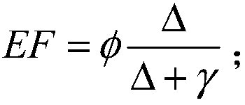
The invention belongs to the technical field of the earth surface evapotranspiration remote sensing estimation, and relates to an evapotranspiration remote sensing inversion method and the applicationbased on the two-dimensional space of the reflectivity-vegetation coverage. The method comprises the steps of: obtaining the relevant data of a target area at the pre-set time scale; determining theprinciple and the definition of the evapotranspiration remote sensing inversion method based on the two-dimensional space of the reflectivity-vegetation coverage, and a variation law of the evapotranspiration ratio in the two-dimensional space of the reflectivity-vegetation coverage; according to the long-term sequence remote sensing short-wave infrared reflectance data and the vegetation coveragedata, determining dry and wet edges of the two-dimensional space of the reflectivity-vegetation coverage, and constructing the two-dimensional space of the reflectivity-vegetation coverage; determining a parameter [Phi] related to the evapotranspiration ratio according to an extended P-T equation and a change of evapotranspiration ratio in the two-dimensional space of the constructed reflectivity-vegetation coverage; and calculating the evapotranspiration of the pre-set time scale based on the determined parameter [Phi]. The evapotranspiration remote sensing inversion method and the application based on the two-dimensional space of the reflectivity-vegetation coverage are of great significance to accurately use the remote sensing to obtain the surface evapotranspiration.

Description

technical field [0001] The invention belongs to the technical field of remote sensing estimation of surface evapotranspiration, and in particular relates to an evapotranspiration remote sensing inversion method and application based on a reflectance-vegetation coverage two-dimensional space. Background technique [0002] Evapotranspiration (Evapotransspiration, ET) is an important part of the surface water cycle and energy balance, which determines the water and heat transfer in the soil-vegetation-atmosphere system. , play an important role. Remote sensing technology is considered to be the most effective method to obtain regional scale evapotranspiration distribution on the earth's surface from the aspects of technology, economy and effectiveness. [0003] At present, the developed remote sensing evapotranspiration estimation methods include one-source model, two-source model and surface temperature-vegetation index triangle / trapezoidal model. The surface temperature-veg...

Claims


Application Information

Patent Timeline
Patent Type & Authority Applications(China)
IPC IPC(8): G01N21/17G01N21/55
CPCG01N21/17G01N21/55G01N2021/1793
Inventor 唐荣林姜亚珍李召良
Owner INST OF GEOGRAPHICAL SCI & NATURAL RESOURCE RES CAS
Learn More