A Method of Oil Spill Area Estimation Based on Image Processing and Laser Ranging

A technology of image processing and laser ranging, which is applied in the fields of marine environmental pollution detection and marine safety protection, to achieve the effects of easy implementation, improved cleaning and recycling efficiency, and low cost

Active Publication Date: 2021-10-22
CSSC SYST ENG RES INST
View PDF4 Cites 0 Cited by
  • Summary
  • Abstract
  • Description
  • Claims
  • Application Information

AI Technical Summary

Problems solved by technology

[0005] This patent is to overcome the shortcomings of the prior art that only uses oil spill radar, and discloses a method for estimating the oil spill area combined with image processing and laser ranging, so as to effectively improve the efficiency of cleaning and recovering oil spills on the sea surface

Method used


Image

  • A Method of Oil Spill Area Estimation Based on Image Processing and Laser Ranging
  • A Method of Oil Spill Area Estimation Based on Image Processing and Laser Ranging
  • A Method of Oil Spill Area Estimation Based on Image Processing and Laser Ranging

Examples


Embodiment Construction
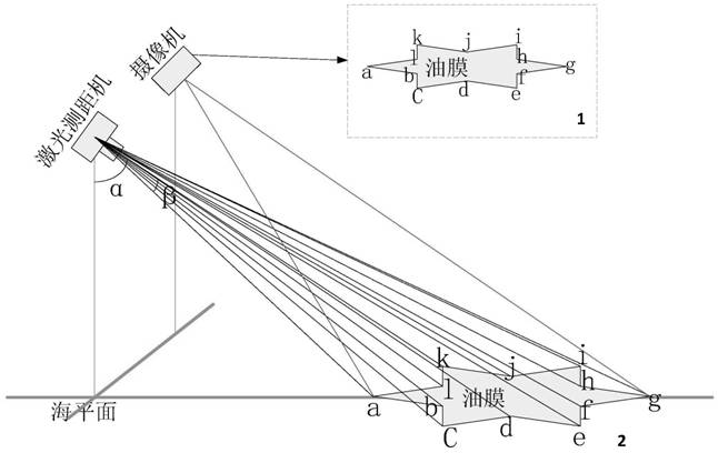
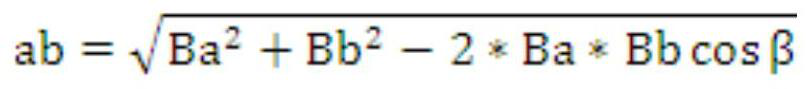
[0021] The technical idea of ​​the present invention first obtains the pixel value of the oil spill area 1 quickly and accurately through the image processing technology, and then obtains the laser distance measuring machine reproduced on the basis of the high-precision two-dimensional servo structure, and measures the oil spill according to the edge conditions obtained by image processing The real distance between different positions of the oil film and the observation point, and the pixel value sum of the oil spill area is converted into the real area size2. Finally, the area calculation is performed by the corresponding area algorithm.

[0022] Specifically, the steps of the oil spill area estimation method based on image processing and laser ranging according to the present invention are as follows:

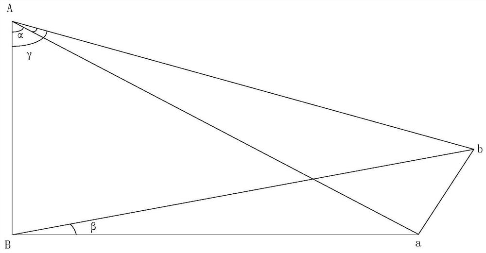
[0023] Step 1. Install the laser rangefinder and camera at the same horizontal position and height. During the installation process, adjust the optical axis of the initial po...


PUM


Abstract

The invention discloses a method for estimating an oil spill area based on image processing and laser ranging, and belongs to the fields of marine environmental pollution detection and marine safety protection. This method first obtains the pixel value of the oil spill area quickly and accurately through image processing technology, and then obtains the laser rangefinder reproduced on the basis of the high-precision two-dimensional servo structure, and measures the distance of different positions of the oil spill film according to the edge conditions obtained by image processing The real distance of the observation point converts the sum of the pixel values ​​of the oil spill area into the real area size. Then calculate the area through the corresponding algorithm. Under the premise of ensuring the estimation accuracy of the oil spill area, the method disclosed in the present invention is easy to implement because the image processing algorithm is relatively mature, and the cost of the laser range finder is also much lower than that of the oil spill radar, which greatly reduces the oil spill estimation The cost of the area can provide a comparison basis for the estimation of the oil spill area of ​​ships equipped with oil spill radar, and effectively improve the cleaning and recovery efficiency of marine oil spill oil pollution.

Description

technical field [0001] The invention belongs to the field of marine environmental pollution detection and marine safety protection, and in particular relates to a method for compositely estimating the oil spill area by image processing and laser ranging. Background technique [0002] As human ocean activities become more and more frequent and have a greater impact on the marine environment, people pay more and more attention to the pollution detection and marine safety protection of the marine environment. In marine environmental pollution incidents, the leakage of crude oil and other refined oil products is the most serious pollution situation, and the removal and recovery of spilled oil has always been the main means to solve such problems. In order to carry out oil spill removal and recovery more quickly and efficiently, it is very necessary and important to estimate the area and volume of oil spill. [0003] The traditional method of estimating the oil spill area is lim...

Claims


Application Information

Patent Timeline
Patent Type & Authority Patents(China)
IPC IPC(8): G06K9/46G06T7/13G06T7/194G06T7/62
CPCG06T7/13G06T7/194G06T7/62G06V10/44
Inventor 王然王国庆赵琪娄越赵欣李鑫陈栋方子璇明磊王宏杰
Owner CSSC SYST ENG RES INST
Why Eureka
Try Eureka