A quantitative analysis method and system for influence factors of land subsidence

A technology of land subsidence and influencing factors, applied in special data processing applications, instruments, electrical digital data processing, etc.

Active Publication Date: 2019-02-26
CAPITAL NORMAL UNIVERSITY
View PDF5 Cites 7 Cited by
  • Summary
  • Abstract
  • Description
  • Claims
  • Application Information

AI Technical Summary

Problems solved by technology

[0004] With the emergence of InSAR technology, large-scale, high-precision monitoring of surface deformation information has become possible, and its monitoring accuracy can reach the millimeter level, and the deformation information of the surface is represented by monitoring points, among which the monitoring points in the Beijing plain area reach hundreds of thousands First, on the basis of obtaining monitoring information, it is necessary to quantitatively analyze the influence of land subsidence factors. , and a simple correlation analysis is used, and there is often a certain interaction between the influencing factors of land subsidence

Method used


Image

  • A quantitative analysis method and system for influence factors of land subsidence
  • A quantitative analysis method and system for influence factors of land subsidence
  • A quantitative analysis method and system for influence factors of land subsidence

Examples


Embodiment 1

[0073] In a specific embodiment, the technical solution proposed by the present invention is realized in the following manner:

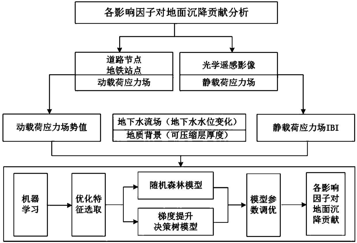
[0074] On the basis of obtaining land subsidence monitoring information, combined with GIS spatial analysis, spatial data mining and machine learning methods, the contribution of various influencing factors of land subsidence (groundwater flow field, dynamic and static load stress field, and geological background) is ascertained. For the dynamic load stress field, the study selects the potential value in the data field model to describe it, extracts the distribution of the rail transit network in the study area, and identifies the spatial distribution of the rail transit load in the study area from the perspective of spatial big data mining. Load and land subsidence are used as data objects, combined with road and subway station nodes in the rail transit network and monitoring points for monitoring surface deformation, to establish a dynamic load data...

Embodiment 2

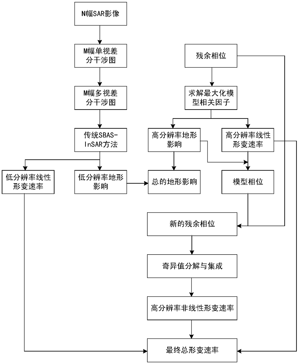
[0108] The main principle of SBAS-InSAR technology is to obtain N radar images in the same area, and generate several pairs of small baseline interference relatives by selecting the small baseline interference combination conditions. Assuming that there are M pairs, a differential interferogram is generated for the images, including M single-view and M multi-view differential interferograms, and then use the traditional SBAS-InSAR technology to extract the linear deformation rate and DEM topographic error of the obtained multi-view differential interferograms, and then extract the high-resolution single-view differential interferograms It is subtracted from the corresponding low-resolution single-view differential interferogram to obtain the residual phase, which mainly includes the deformation phase and the terrain phase. The formula can be expressed as:

[0109]

[0110] Among them, υ(x,r) and are the high-resolution mean velocity and nonlinear components in residual de...

Embodiment 3

[0181] In yet another specific embodiment, the technical solution of the present invention can also be realized by means of a system, and the system can execute the methods described in Embodiment 1 and Embodiment 2. Specifically, the present invention also provides a quantitative analysis system for factors affecting land subsidence, the system comprising:

[0182]The dynamic load stress field calculation module is used to select the corresponding dynamic load data object in the region, establish the dynamic load stress field, and quantify the distribution of the dynamic load stress field with the field potential value of the dynamic load stress field;

[0183] The static load stress field calculation module is used to perform radiation correction on the remote sensing image of the area, and construct an IBI index model based on the soil-adjusted vegetation index, the corrected normalized water index and the normalized building index;

[0184] The impact degree calculation mo...


PUM


Abstract

The invention provides a quantitative analysis method for influencing factors of land subsidence. The method comprises: selecting a corresponding dynamic load data object in a region, establishing a dynamic load stress field, and quantitatively quantifying the distribution of the dynamic load stress field according to the field potential value of the dynamic load stress field; performing radiometric correction on remote sensing image of the region, and constructing an IBI index model based on the soil-regulated vegetation index, the modified normalized water index and the normalized building index; selecting a plurality of influence factors of the region, and obtaining the influence degree of each influence factor by using a machine learning method. From the viewpoint of big data, the invention synthetically considers a plurality of factors influencing the land subsidence, and more objectively reflects the contribution of each influence factor in the land subsidence.

Description

technical field [0001] The invention relates to the field of quantitative calculation of land subsidence, in particular to a quantitative analysis method and system for determining the degree of influence of various influencing factors of land subsidence in land subsidence through big data. Background technique [0002] Land subsidence, as the surface response to the development, utilization and evolution of underground space, occurs under the joint action of natural and human factors, and is an environmental geological phenomenon of ground elevation loss. The multivariate field of land subsidence consists of surface deformation field, groundwater seepage field and dynamic and static load stress field. The occurrence of land subsidence is irreversible. When the land subsidence is severe, it will induce a series of geological environmental disasters and form a disaster chain. According to data, at present, land subsidence has occurred in more than 150 regions around the worl...

Claims


Application Information

Patent Timeline
Patent Type & Authority Applications(China)
IPC IPC(8): G06F17/50
CPCG06F30/00
Inventor 周超凡陈蓓蓓宫辉力李小娟高明亮郭琳史珉
Owner CAPITAL NORMAL UNIVERSITY
Why Eureka
Try Eureka