visualization and safety management system and method based on an ArcGIS tailing pond

A technology for safety management and tailings ponds, applied in the field of visualization and safety management systems based on ArcGIS tailings ponds, can solve problems such as not considering the surroundings of tailings ponds, and achieve the effect of simple operation

Active Publication Date: 2019-04-19
TIANJIN UNIV
View PDF7 Cites 8 Cited by
  • Summary
  • Abstract
  • Description
  • Claims
  • Application Information

AI Technical Summary

Problems solved by technology

However, because the tailings pond waste will have a great impact on people and creatures around the tailings pond, it has not considered a detailed plan for the surrounding tailings pond, such as data visualization for villages and hospitals around the tailings pond

Method used


Image

  • visualization and safety management system and method based on an ArcGIS tailing pond
  • visualization and safety management system and method based on an ArcGIS tailing pond
  • visualization and safety management system and method based on an ArcGIS tailing pond

Examples


Embodiment Construction

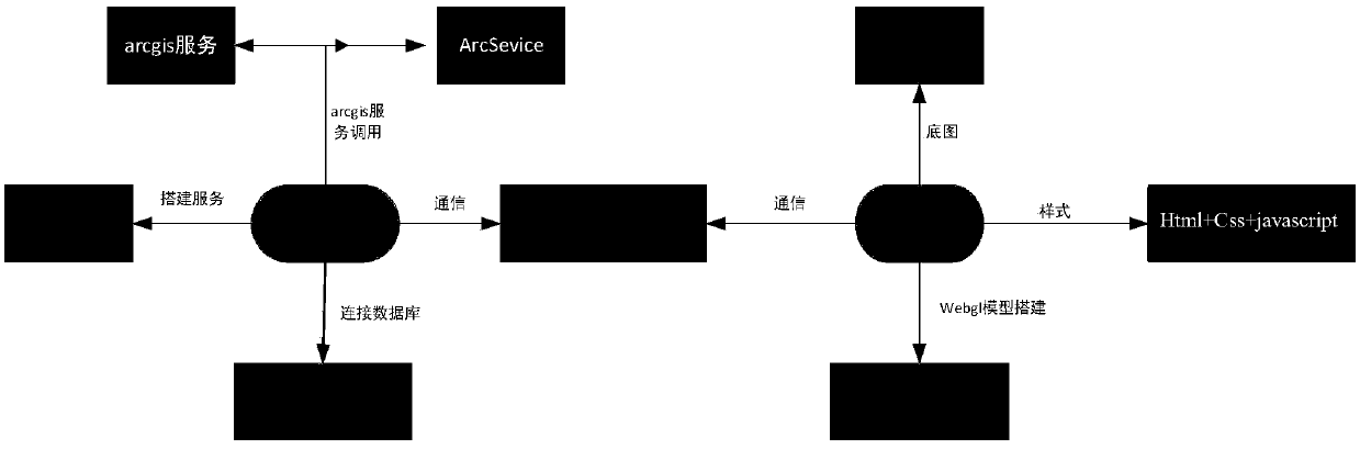
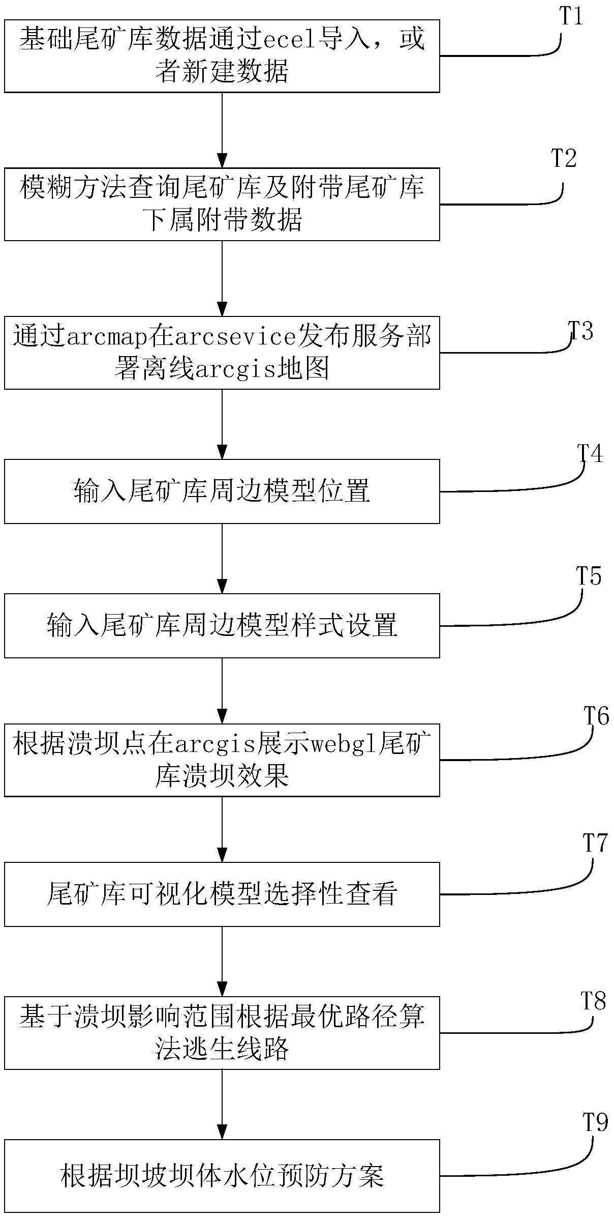
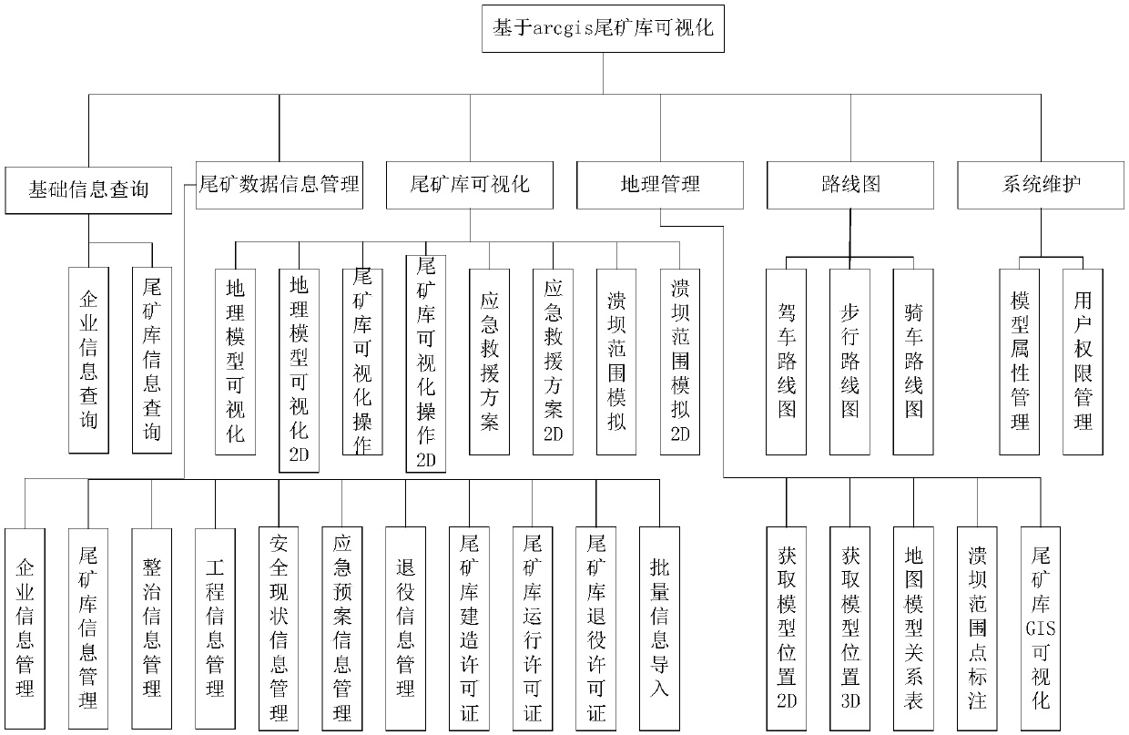
[0060] The present invention is based on the visualization and safety management system of ArcGIS tailings pond, and the method comprises:

[0061] Tailings pond basic database management, including basic information, preview and download of videos, pictures and files.

[0062] Load and build ArcGIS maps offline.

[0063] Display small icons of all tailings ponds on the national map, and click to switch the specific location details of tailings ponds.

[0064] Based on the information around the tailings pond in ArcGIS, the visualization model is built and the information is viewed.

[0065] Based on the WebGL model and the ArcGIS map, the dynamic demonstration of the dam failure effect of the tailings pond.

[0066] According to the surrounding information model, the emergency rescue plan is designed in real time.

[0067] Measure straight lines and area functions based on ArcGIS

[0068] The invention provides a visualization and safety management system based on ArcGIS ...


PUM


Abstract

The invention relates to safety monitoring technology, which is capable of visualizing a geographic information of a tailings pond through a national map, designing an emergency rescue plan, and demonstrating a dam break effect. The present invention is based on an ArcGIS tailings library visualization and safety management system and method. The system includes a batch data import module, an information dynamic query module, a peripheral information model building module based on ArcGIS tailings library, a visualization display module based on ArcGIS tailings library surrounding information,a module for switching tail mine library specific location details, a module based on ArcGIS emergency rescue and escape, a module for dynamically displaying the dam break effect based on ArcGIS; a batch data import module. the visualization display module based on ArcGIS tailings library surrounding information is used to: download the base map of the ArcGIS base map, and publish the map servicethrough ArcMap. The invention is mainly applied to mine safety monitoring occasions.

Description

technical field [0001] The invention relates to the technical field of the Internet, in particular to a visualization and safety management system and method for tailings pools based on ArcGIS. Background technique [0002] Tailings pool refers to the place where dams are built to intercept valley mouths or enclosures, and are used to stockpile metal or non-metal mines for ore sorting and then discharge tailings or other industrial waste. The tailings pond is a high potential energy man-made debris flow hazard, and there is a danger of dam failure. Once the accident occurs, it is easy to cause serious accidents. There are many tailings ponds distributed all over the country. For the safety management of tailings ponds (slag), in order to prevent and reduce production safety accidents in tailings ponds, and ensure the safety of people's lives and property. There are many monitoring systems for the safety management of tailings ponds at home and abroad. Such as online-SME, M...

Claims


Application Information

Patent Timeline
Patent Type & Authority Applications(China)
IPC IPC(8): G06F16/29G06Q10/10G06Q50/26
CPCG06Q10/103G06Q50/265Y02A10/40
Inventor 张鹏许林英
Owner TIANJIN UNIV
Why Eureka
Try Eureka