Sea surface temperature fusing method and system

A technology of sea surface temperature and fusion method, applied in the field of marine information, can solve problems such as the influence of spatial coverage, and achieve the effects of high spatial coverage, high precision, and high spatial resolution

Active Publication Date: 2019-04-23
中国人民解放军61741部队
View PDF3 Cites 17 Cited by
  • Summary
  • Abstract
  • Description
  • Claims
  • Application Information

AI Technical Summary

Problems solved by technology

Its observation frequency is once every 10 minutes, it has 16 spectral channels, and the spatial resolution of the infrared channel reaches 2 kilometers. advantage, but at the same time, due to the occlusion of clouds and fog, the space coverage is greatly affected

Method used


Image

  • Sea surface temperature fusing method and system
  • Sea surface temperature fusing method and system
  • Sea surface temperature fusing method and system

Examples


Embodiment 1

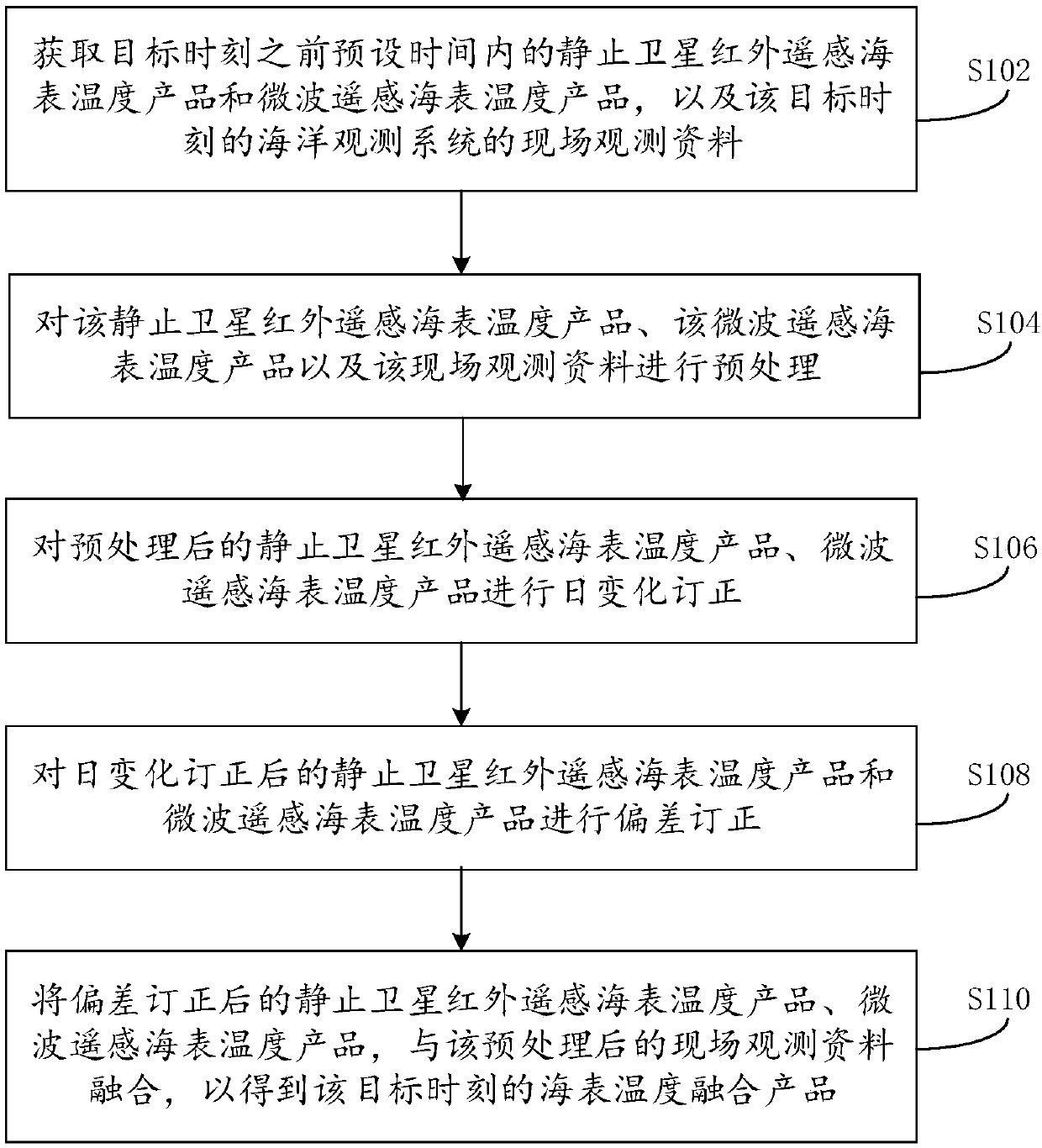
[0037] like figure 1 As shown, it is a flow chart of a sea surface temperature fusion method provided by the embodiment of the present invention, consisting of figure 1 Visible, this method comprises the following steps:

[0038] Step S102: Obtain the geostationary satellite infrared remote sensing sea surface temperature products and microwave remote sensing sea surface temperature products within the preset time before the target time, as well as the on-site observation data of the ocean observation system at the target time.

[0039] Here, the sea surface fusion temperature obtained by the sea surface temperature fusion method is the sea surface temperature at the target moment. The target moment may be the current moment, or any moment in history.

[0040] Among them, the sea surface temperature products obtained by infrared remote sensing of geostationary satellites are sea surface temperature products obtained by infrared remote sensing of geostationary satellites. se...

Embodiment 2

[0096] In order to test the accuracy of the above sea surface temperature fusion method, this example selects Himawari-8 sea surface temperature, AMSR2 sea surface temperature and NERA-GOOS field observation data in the northwestern Pacific Ocean for fusion experiments.

[0097] In this example, the NERA-GOOS on-site observation data in April 2017 are selected to test the accuracy of the sea surface temperature fusion results. The spatial matching standard of the two is that the observation position interval is less than 2km, and the temporal matching standard is that the observation time interval is less than In 30 minutes, there were 9916 matching data points, 1000 field observation data were randomly selected to participate in sea surface temperature fusion, and the remaining 8916 field observation data were used for the accuracy test of sea surface temperature fusion results. The test results are shown in Figure 8.

[0098] in, Figure 8a It is the spatial distribution of ...

Embodiment 3

[0100] The embodiment of the present invention also provides a sea surface temperature fusion system, see Figure 9 , is the structural diagram of the system, by Figure 9 It can be seen that the system includes a data acquisition module 21, a preprocessing module 22, a diurnal variation correction module 23, a deviation correction module 24 and a temperature fusion module 25 connected to each other, wherein the functions of each module are as follows:

[0101] The data acquisition module 21 is used to obtain the geostationary satellite infrared remote sensing sea surface temperature product and the microwave remote sensing sea surface temperature product within the preset time before the target moment, and the on-site observation data of the ocean observation system at the target moment;

[0102] Preprocessing module 22 is used for preprocessing the geostationary satellite infrared remote sensing sea surface temperature product, the microwave remote sensing sea surface temper...


PUM


Abstract

The invention provides a sea surface temperature fusing method and system, and relates to the technical field of sea information. The method comprises the following steps: acquiring stationary satellite infrared remote sensing and microwave remote sensing sea surface temperature products in preset time before a target moment and on-site observation data of a sea observation system at the target moment; preprocessing the sea surface temperature products and the on-site observation data; carrying out daily change correction on the preprocessed sea surface temperature products; carrying out deviation correction on the stationary satellite infrared remote sensing temperature products and the microwave remote sensing sea surface temperature products subjected to daily change correction; fusingthe stationary satellite infrared remote sensing temperature products and the microwave remote sensing sea surface temperature products subjected to daily change correction with the preprocessed on-site observation data, so as to obtain sea surface temperature fusing products at the target moment. The sea surface temperature fusing method and system of the embodiment of the invention are capable of obtaining the sea surface temperature fusing products with high time-space resolution, high space coverage degree, gradual time level and high accuracy.

Description

technical field [0001] The present invention relates to the technical field of marine information, in particular to a sea surface temperature fusion method and system. Background technique [0002] Sea surface temperature is an important geophysical parameter for the study of material and energy exchange at the air-sea interface, and plays an important role in climate change research. It characterizes the thermal and dynamic processes of the ocean, and is affected by the interaction between the ocean and the atmosphere. It provides an important basis for the study of ocean phenomena such as ocean circulation, mesoscale eddies, ocean fronts, upwelling, and seawater mixing. [0003] The Himawari-8 satellite is a new generation of geosynchronous geostationary meteorological satellite launched by the Japan Meteorological Agency on October 7, 2014. It is equipped with the Advanced Himawari Imager (AHI). Its observation frequency is once every 10 minutes, it has 16 spectral chann...

Claims


Application Information

Patent Timeline
Patent Type & Authority Applications(China)
IPC IPC(8): G01J5/00
CPCG01J5/0037G01J2005/0077G01J5/80
Inventor 周旋李自强王彦磊周江涛刘春笑董兆俊邵连军白志鹏施英妮张芳苒
Owner 中国人民解放军61741部队
Why Eureka
Try Eureka