A crop disaster loss rapid assessment method

A crop and disaster technology, applied in the field of agricultural remote sensing, can solve the problems of low operation efficiency, complicated data collection, limited time of statistical models, etc., to reduce time costs, improve evaluation efficiency, and save costs.

Inactive Publication Date: 2019-05-03
BEIJING NORMAL UNIVERSITY
View PDF3 Cites 11 Cited by
  • Summary
  • Abstract
  • Description
  • Claims
  • Application Information

AI Technical Summary

Problems solved by technology

This method is based on the assumption that crop yield reduction is caused by chilling damage, and the evaluation effect on single disaster loss is poor, and dynamic evaluation cannot be performed.
2) Based on the historical observation data, construct the regression equation of disaster index and output, and extrapolate the disaster loss, but the disaster index is very regional, it is difficult to expand and apply to other regions, and it cannot meet the loss assessment below the county level
The combination of remote sensing and crop models can realize continuous yield simulation at different spatial resolutions, solve the regional scal

Method used


Image

  • A crop disaster loss rapid assessment method
  • A crop disaster loss rapid assessment method
  • A crop disaster loss rapid assessment method

Examples


Embodiment Construction

[0029] In order to have a clearer understanding of the technical features, purposes and effects of the present invention, the specific implementation manners of the present invention will now be described with reference to the accompanying drawings. Wherein, the same parts adopt the same reference numerals.

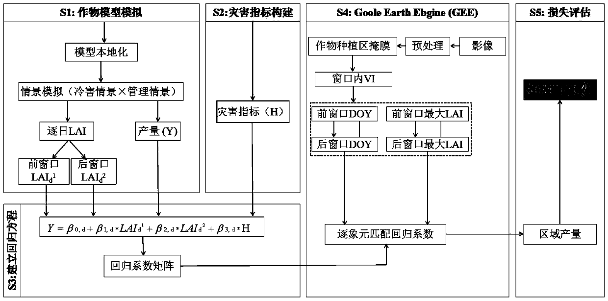
[0030] Based on the aforementioned problems in the prior art, the present invention combines remote sensing observation data, meteorological data and crop models to create a rapid assessment method for disaster losses extended from points to regions. This method is not limited by ground measured data, can be dynamically evaluated, is easy to operate, and has strong generalization ability. It can not only conduct large-scale research, but also quantify county-level and even field losses, aiming to achieve fine mapping of crop yield losses. , in order to provide reference for the operational operation of disaster assessment and provide guarantee for disaster prevention and ...


PUM


Abstract

The invention provides a crop disaster loss rapid assessment method, which is based on a crop model of a DSSAT system and a GLUE parameter estimation tool, utilizes historical data of crops in a disaster area, obtains leaf area indexes and yields of the crops under various scenes based on crop model simulation, and further constructs a regression equation. And then based on a satellite image of Google Enth (GEE), substituting the leaf area index of each pixel on the satellite image into a linear regression equation to obtain the yield of each pixel. And finally, comparing the yield of the disaster year of the disaster area with the yield of the last year to obtain the relative yield loss. According to the method, a large amount of ground observation data is not needed, only a small amountof experimental data is needed for calibration, the evaluation efficiency is improved, the time cost of disaster loss evaluation is reduced, and a guarantee is provided for disaster prevention and reduction. According to the method, quantitative assessment of disaster loss is achieved, the yield reduction rates of different spatial scales can be reliably estimated, and the quality of disaster assessment is improved.

Description

technical field [0001] The invention relates to the technical field of agricultural remote sensing, in particular to a cross-scale and quantitative evaluation method for crop disaster losses based on a remote sensing data processing platform Google EarthEngine (GEE) and a crop model, in particular to a method for quickly evaluating crop disaster losses. Background technique [0002] Agriculture and weather are closely related. The whole process of crop growth is in the natural environment, and the formation of its yield is extremely vulnerable to the coercion and interference of unfavorable factors such as meteorological disasters. Severe disasters can lead to a sharp decline in grain production or even extinction. At present, the assessment of agricultural meteorological disasters is mainly divided into two categories: risk assessment and impact assessment. Risk means the possibility of disaster occurrence and damage. The technical basis of assessment is risk analysis tech...

Claims


Application Information

Patent Timeline
IPC IPC(8): G06F17/50G06F17/18G06Q50/02
Inventor 张朝张亮亮陶福禄骆玉川李子悦
Owner BEIJING NORMAL UNIVERSITY
Why Eureka
Try Eureka