Cross-scale high-precision dynamic crop growth monitoring and yield assessment method based on high-resolution remote sensing data and a crop model

A remote sensing data, high-precision technology, applied in the field of agricultural remote sensing, can solve the problems of high demand for ground measured data, uncertainty of assimilation algorithm, weak model space application ability, etc.

Active Publication Date: 2019-05-31
BEIJING NORMAL UNIVERSITY
View PDF4 Cites 31 Cited by
  • Summary
  • Abstract
  • Description
  • Claims
  • Application Information

AI Technical Summary

Problems solved by technology

[0006] In order to solve the problems of high demand and difficulty in obtaining ground actual measurement data existing in crop yield estimation, weak model space application ability, uncertainty of assimilation algorithm and high calculation cost, the present invention provides a method based on Google EarthEngine (GEE) and crop growth The high-precision agricultural yield estimation method of the m...

Method used


Image

  • Cross-scale high-precision dynamic crop growth monitoring and yield assessment method based on high-resolution remote sensing data and a crop model
  • Cross-scale high-precision dynamic crop growth monitoring and yield assessment method based on high-resolution remote sensing data and a crop model
  • Cross-scale high-precision dynamic crop growth monitoring and yield assessment method based on high-resolution remote sensing data and a crop model

Examples


Embodiment

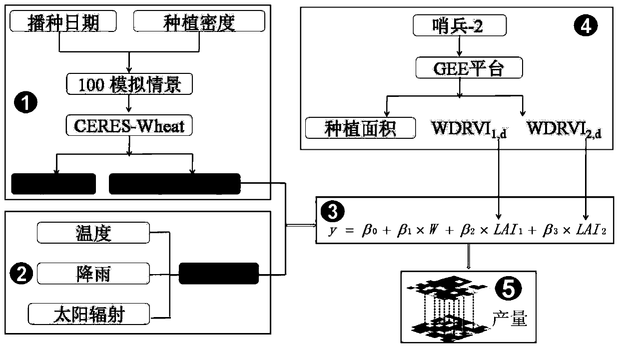
[0082] Taking wheat as an example below, the specific implementation process of the method of the present invention will be exemplarily described.

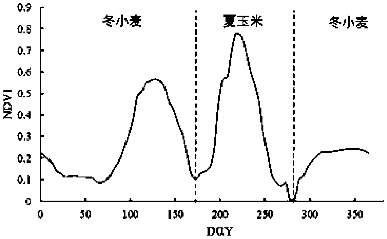
[0083]Step S1, select the main winter wheat production area in Dingzhou, Anhui, North China Plain as the research area, between 114°48'-115°15' east longitude and 38°14'-38°40' north latitude, with a total area of ​​127,500ha. The terrain is flat, and the Shahe River, Mengliang River and Tang River run through the whole area. The main crops are winter wheat, summer corn, cotton and some other crops. The area is dominated by yellow cinnamon soil and belongs to semi-arid monsoon climate. The annual average temperature and precipitation are 12.4°C and 503.2mm respectively, the frost-free period is 170-190 days, and the annual accumulated temperature is 4200-4800°C.

[0084] Step S2, use the GEE platform to preprocess the Sentinel-2 image data from 2015 to 2018, including atmospheric correction, radiation correction and collective cor...


PUM


Abstract

The invention discloses a cross-scale high-precision dynamic crop growth monitoring and yield assessment method based on high-resolution satellite remote sensing data and a crop model. The method comprises the steps of achieving localization of the model is achieved; performing spatial matching on the remote sensing data and the ground data by using a GEE platform; designing a plurality of simulation scenes; dividing the growth period of the crops into a front time window and a rear time window by taking the green returning period as a node, and calculating various meteorological factors in the whole growth period; constructing a regression equation, and establishing a regression equation of each day in all growth periods; Extracting the maximum values of the satellite remote sensing observation vegetation indexes of two time windows before and after each year and corresponding dates thereof pixel by pixel, and converting the extracted maximum values of the vegetation indexes into independent variables LAI of a regression equation through an empirical formula; And taking the observation dates of the two time windows before and after extraction as references, carrying out pixel-by-pixel calculation by utilizing a regression equation corresponding to the combination date, and obtaining the crop simulation yield after operation on all pixels is completed.

Description

technical field [0001] The invention relates to the technical field of agricultural remote sensing, and more specifically to a cross-scale and high-precision dynamic crop growth monitoring and yield estimation method based on high-resolution remote sensing data and crop models. Background technique [0002] Traditional crop yield estimation methods are mainly divided into forecasting methods based on agronomic statistics, agricultural meteorological statistics, economic statistics and crop models. Due to the high time, manpower and material resources and the limitations of the crop model itself, these methods are difficult to achieve high-precision yield estimation of regional crops, especially the field-scale yield estimation. Remote sensing technology has three important characteristics of rapidity, macroscopicity and dynamics. It can quickly obtain large-scale surface information, and plays a huge role in large-scale crop growth monitoring and yield forecasting. It has un...

Claims


Application Information

Patent Timeline
IPC IPC(8): G06F17/50G06F17/11G06F17/18G06Q50/02
Inventor 张朝曹娟陶福禄骆玉川李子悦
Owner BEIJING NORMAL UNIVERSITY
Why Eureka
Try Eureka