
Combined indoor pedestrian navigation system and method based on UWB and SINS

A technology for pedestrian navigation and navigation calculation, which is applied in the combined indoor pedestrian navigation system and field based on UWB and SINS, and can solve the problem of unusable positioning error for a long time.

Active Publication Date: 2019-06-07
STATE GRID JIANGSU ELECTRIC POWER CO LTD MAINTENANCE BRANCH
View PDF10 Cites 10 Cited by
  • Summary
  • Abstract
  • Description
  • Claims
  • Application Information

AI Technical Summary

Problems solved by technology

[0015] In the formula, current moment speed, is the position at the current moment, t is the time; the error of adding the table is included in , the gyroscopic error is contained in , over time, with ε b The constant value calculation error will accumulate at the growth rate of the power of 2, and the long-term positioning error is too large to be used

Method used


Image

  • Combined indoor pedestrian navigation system and method based on UWB and SINS
  • Combined indoor pedestrian navigation system and method based on UWB and SINS
  • Combined indoor pedestrian navigation system and method based on UWB and SINS

Examples


Embodiment 1

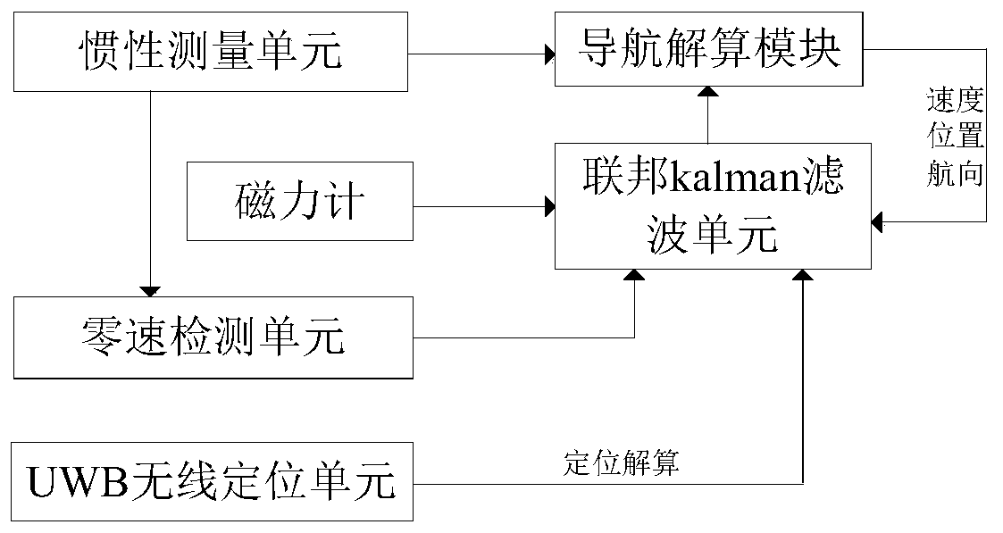
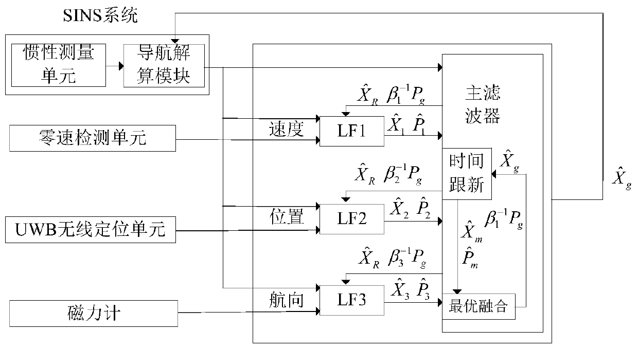
[0070] An embodiment of the present invention provides a combined indoor pedestrian navigation device based on UWB and SINS, such as Figure 1-2 shown, including:

[0071] SINS unit, the SINS unit includes a connected inertial measurement unit and a navigation calculation module, the inertial measurement unit is used to collect human body motion acceleration and rotational angular velocity; the navigation calculation module receives and based on the human body motion acceleration and rotation Calculate the heading angle and position information from the angular velocity;

[0072] A zero-speed detection unit, the input end of the zero-speed detection unit is connected to the output end of the inertial measurement unit, and is used to receive the human body motion acceleration and rotational angular velocity output by the inertial measurement unit, and based on the human body motion acceleration and rotational angular velocity Carry out zero-speed judgment; in a kind of specifi...

Embodiment 2

[0130] The embodiment of the present invention provides a combined indoor pedestrian navigation method based on UWB and SINS, comprising the following steps:

[0131] Step (1) Use the inertial measurement unit to collect the acceleration of human motion and the angular velocity of rotation, and use the navigation calculation module to calculate the heading angle and position information based on the acceleration of motion of the human body and the angular velocity of rotation; The signal is integrated to obtain an attitude signal, and the attitude signal includes a pitch angle, a roll angle and a heading angle, and the heading angle is the heading angle; the calculation process of the position information is also an existing technology, so in this paper Do not repeat too much in the embodiment of the invention;

[0132] Step (2) Utilize the zero-speed detection unit based on the human body motion acceleration and rotational angular velocity output by the inertial measurement u...


PUM


Abstract

The invention discloses a combined indoor pedestrian navigation system and method based on UWB and SINS. The system comprises an inertial measurement unit, a navigation solution module, a zero velocity detection unit, a UWB wireless positioning unit, a magnetometer and a federated kalman filtering unit. The federated kalman filtering unit carries out data fusion on output signals of the navigationsolution module, the zero velocity detection unit, the UWB wireless positioning unit and the magnetometer to obtain error signals of human motion acceleration, course angle and position information and sends the error signals to the inertial measurement unit for correction. The method introduces a zero velocity correction technique on the basis of a conventional strapdown algorithm to detect zerovelocity moment; in an ultra-wideband signal region, position course angle is provided by utilizing the ultra wide band; in a non-ultra-wideband signal region, the course angle is provided by utilizing a magnetometer; and zero speed, position and course angle information are fused through federated kalman filtering to correct the speed, position and course of the navigation system, thereby realizing indoor personnel positioning.

Description

technical field [0001] The invention belongs to the technical field, and in particular relates to a combined indoor pedestrian navigation system and method based on UWB and SINS. Background technique [0002] Pedestrian navigation began in the 1980s and 1990s, and its development was late and slow. It was not until 1996 when the US Federal Communications Commission announced the positioning requirements of E-911 that pedestrian navigation gradually developed. The pedestrian navigation system is mainly used to track personal location information in real time and provide location services. It can provide services for soldiers and rescue personnel, and provide a higher level of security for high-risk workers. [0003] Outdoor GPS / LBS positioning technology is very mature and has been successfully used in vehicles, mobile phones and other equipment. However, in indoor or places where the signal is seriously blocked, the Global Positioning System (GPS) or Space Positioning Servi...

Claims


Application Information

Patent Timeline
IPC IPC(8): G01C21/20G01C21/16
CPCY02D30/70
Inventor 陈昊陈玮光刘锡祥汪宋兵张建忠姚龙华邓凯王煜
Owner STATE GRID JIANGSU ELECTRIC POWER CO LTD MAINTENANCE BRANCH
Learn More