Interferometric synthetic aperture radar (InSAR) and global navigation satellite system (GNSS) weight determining method aiming at three-dimensional ground surface deformation estimation

A surface deformation, three-dimensional technology, applied in the reflection/re-radiation of radio waves, satellite radio beacon positioning systems, and the use of re-radiation, etc. and other problems to achieve the effect of improving accuracy and universality

Active Publication Date: 2019-07-26
CENT SOUTH UNIV
View PDF7 Cites 17 Cited by
  • Summary
  • Abstract
  • Description
  • Claims
  • Application Information

AI Technical Summary

Problems solved by technology

However, InSAR observation errors are often spatially different, so its weighting accuracy is limited
In addition, through the empirical formula of InSAR observation accuracy and coherence, the prior variance estimation of the observations can also be obtained, but this method is difficult to reflect the influence of atmospheric and other long-wave errors in the observations

Method used


Image

  • Interferometric synthetic aperture radar (InSAR) and global navigation satellite system (GNSS) weight determining method aiming at three-dimensional ground surface deformation estimation
  • Interferometric synthetic aperture radar (InSAR) and global navigation satellite system (GNSS) weight determining method aiming at three-dimensional ground surface deformation estimation
  • Interferometric synthetic aperture radar (InSAR) and global navigation satellite system (GNSS) weight determining method aiming at three-dimensional ground surface deformation estimation

Examples


Embodiment 1

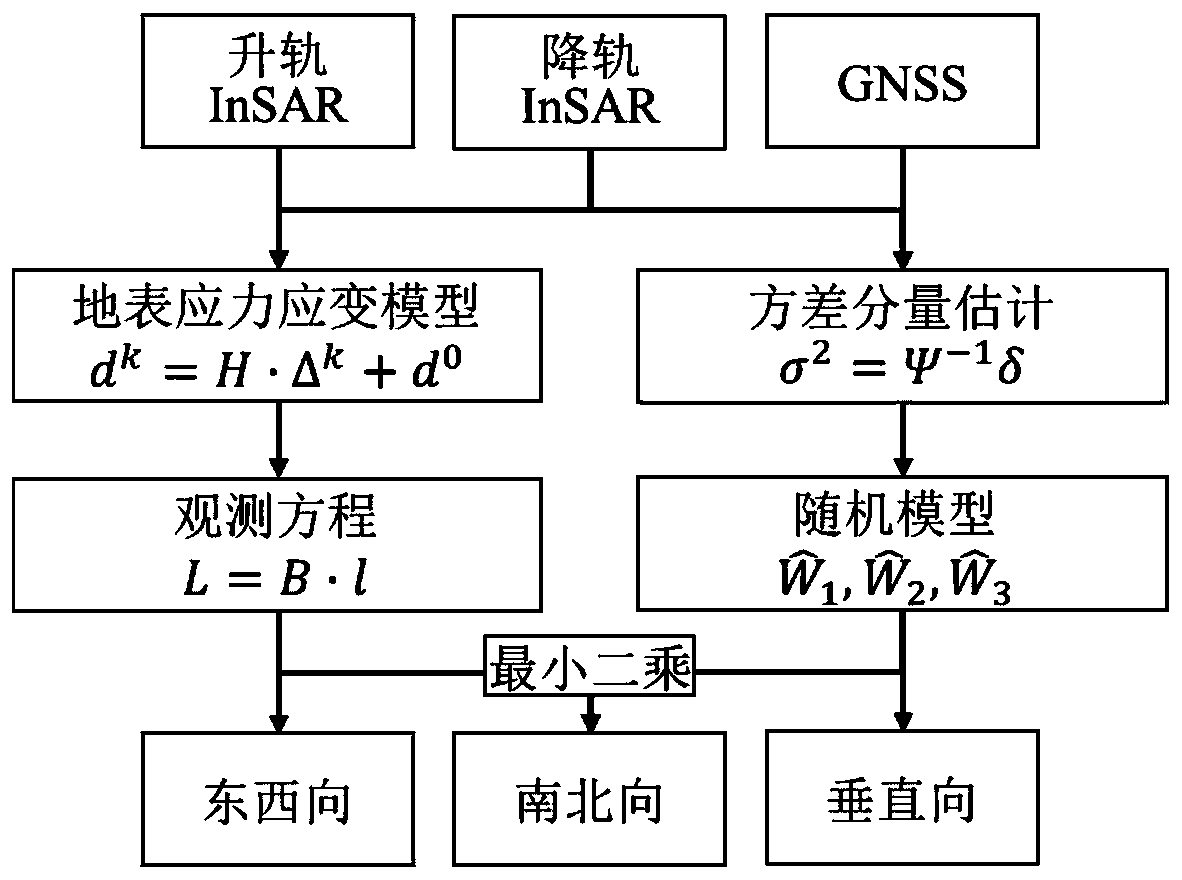
[0062] like figure 1 As shown, the specific implementation of this embodiment is as follows:

[0063] Step 1: Using the orbit-raising and descending InSAR data of the area to be monitored and the GNSS data of the area, based on the surface stress and strain model (Strain Model, SM), establish the three-dimensional surface deformation of the unknown point and a certain number of InSAR / GNSS around the point. functional relationship between data;

[0064] How to determine the amount of InSAR / GNSS data used to build the functional relationship is described in step 2.

[0065] Suppose the unknown point P 0 The three-dimensional coordinates and three-dimensional deformation of around a little P k The three-dimensional coordinates and three-dimensional deformation of Then according to the surface stress-strain model, there is the following formula:

[0066] d k =H.Δ k +d 0 (1)

[0067] in H represents the unknown parameter matrix of the stress-strain model, which c...

Embodiment 2

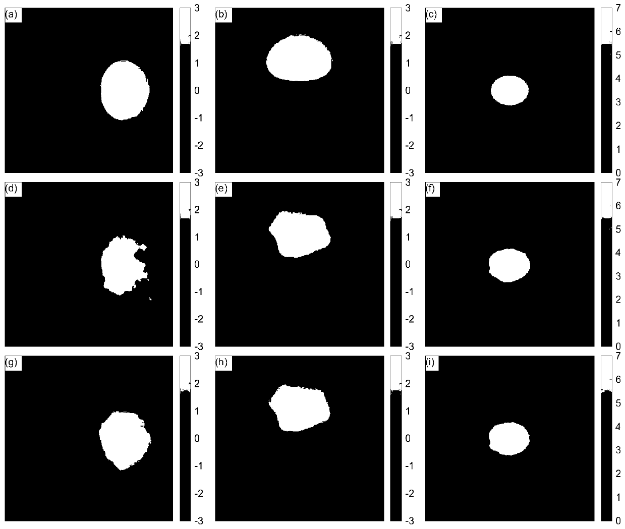
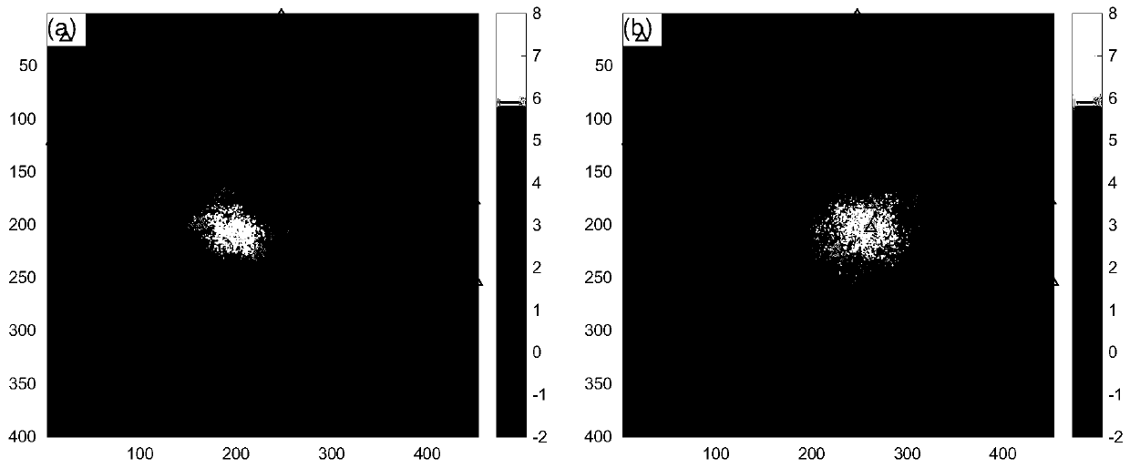
[0121] This implementation verifies the present invention through experiments, such as Figure 2-3 shown, where, figure 2 (a)-(c) are the original simulated east-west, north-south and vertical deformation data in turn, figure 2 (d)-(f) are the east-west, north-south and vertical deformation data obtained by the traditional method in turn, figure 2 (g)-(i) are the east-west, north-south and vertical deformation data obtained by the method of the present invention in turn (unit: cm); image 3 (a) is the orbit-raising InSAR data, image 3 (b) is the down-orbit InSAR data, the triangles in the figure represent the location distribution of GNSS stations (unit: cm).

[0122] Description of simulated data: ① Simulate east-west, north-south and vertical three-dimensional deformation fields in a certain area (image size 400×450) (such as figure 2 (a)-(c)); ② Combined with the imaging geometry of Sentinel-1A / B satellite data, calculate the InSAR deformation results of orbit up a...


PUM


Abstract

The invention discloses an interferometric synthetic aperture radar (InSAR) and global navigation satellite system (GNSS) weight determining method aiming at three-dimensional ground surface deformation estimation. The InSAR and GNSS weight determining method comprises the steps that 1, by utilizing ascending rail InSAR data and descending rail InSAR data of a to-be-monitored area and GNSS data ofthe to-be-monitored area, the function relationship between three-dimensional deformation d<0> of an unknown point and a certain quantity of the InSAR / GNSS data L of surrounding points is established based on a ground surface stress strain model and observed value imaging geometry; 2, K observed data in the ascending rail InSAR, descending rail InSAR and GNSS observed values L are subjected to relative weight determining, and an initial weight matrix W of all kinds of observed values of InSAR / GNSS is determined; 3, a precise weight matrix hat{W} between all kinds of observed values of InSAR / GNSS is estimated and determined through variance components, and high-precision three-dimensional deformation d<0> is solved based on the least squares criterion; and 4, as for each ground surface point, InSAR and GNSS fusion estimation of a high-precision three-dimensional ground surface deformation field is achieved through the step 1 to the step 3.

Description

technical field [0001] The invention relates to the field of geodetic surveying of remote sensing images, in particular to an InSAR and GNSS weight determination method oriented to three-dimensional surface deformation estimation. Background technique [0002] Synthetic aperture radar interferometry (Interferometric Synthetic Aperture Radar, SAR, InSAR) and Global Navigation Satellite System (Global Navigation Satellite System, GNSS) have been widely used to obtain surface deformation caused by earthquakes, volcanoes, underground mining and so on. InSAR technology can process two SAR images of the same area at different times (with an interval of several days to hundreds of days) to obtain a one-dimensional image of a certain resolution unit (several meters to tens of meters) on the surface along the radar line of sight within this time interval. The average deformation results, the observation accuracy is generally in the millimeter or centimeter level. GNSS technology obt...

Claims


Application Information

Patent Timeline
Patent Type & Authority Applications(China)
IPC IPC(8): G01S13/90G01B15/06
CPCG01S13/90G01B15/06G01S13/9023G01S19/48G01S19/14G01S19/43G06F17/16G01S19/485
Inventor 刘计洪胡俊李志伟朱建军
Owner CENT SOUTH UNIV
Why Eureka
Try Eureka