
Multi-channel pollution discharge emergency telemetering imaging system and method

A pollution emission and imaging system technology, which is applied in radio wave measurement systems, measurement devices, color/spectral characteristic measurement, etc., can solve problems such as inability to measure multiple components simultaneously, laser hazards, and inability to obtain pollutant level distribution information, etc.

Pending Publication Date: 2019-08-06
HEFEI INSTITUTES OF PHYSICAL SCIENCE - CHINESE ACAD OF SCI
View PDF6 Cites 8 Cited by
  • Summary
  • Abstract
  • Description
  • Claims
  • Application Information

AI Technical Summary

Problems solved by technology

Lidar technology is limited by the wavelength of the laser, so it cannot measure multiple components at the same time. When detecting the horizontal distribution of low-level pollution gases, the laser emitted is dangerous and not suitable for gas detection.
Although passive Fourier transform technology can remotely measure pollution emission sources, due to the limitation of observation methods, it is impossible to quickly obtain the two-dimensional distribution information of pollutants
Passive differential absorption spectroscopy generally pays more attention to the distribution of column concentration in the vertical direction, and cannot obtain the horizontal distribution information of pollutants

Method used


Image

  • Multi-channel pollution discharge emergency telemetering imaging system and method
  • Multi-channel pollution discharge emergency telemetering imaging system and method

Examples


Embodiment 1

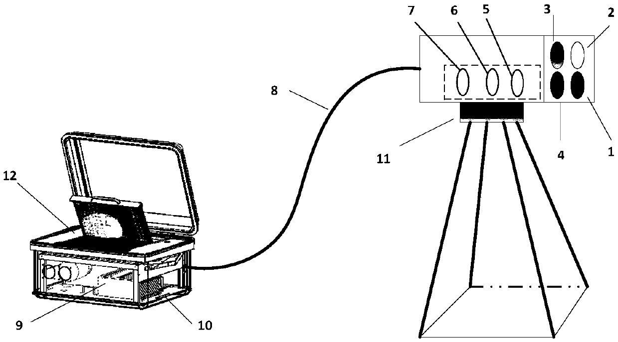
[0032] see figure 2 : A kind of multi-channel pollution emission emergency telemetry imaging system of the present embodiment, including optical introduction unit, ultraviolet spectrum acquisition system, high-precision scanning platform (11), multi-bundle optical fiber (8), high-resolution spectrometer (9), CCD detection device, computer 12; the optical introduction unit is used to synchronously acquire visible images, ultraviolet spectra, laser ranging, infrared thermal imaging; ) is transmitted to the high-resolution spectrometer (9); the high-resolution spectrometer (9) images the received atmospheric scattered light on the CCD detector through a grating, and performs spectral processing by a computer (12) after analog-to-digital conversion; The optical introduction unit and the ultraviolet spectrum acquisition system are placed on the high-precision scanning platform (11); the high-precision scanning platform (11) is a rotating platform configured with a stepper motor an...

Embodiment 2

[0034] A multi-channel pollution discharge emergency telemetry imaging system of this embodiment has basically the same structure as that of Embodiment 1, the main difference is that: the optical path of the ultraviolet spectrum collection system is sequentially equipped with optical filters (5), quasi Straight lens (6), focusing lens (7), described optical filter (5), collimating lens (6), focusing lens (7) all adopt quartz material, and described optical filter (5) is 300nm-500nm The ultraviolet filter, the optical introduction unit is a four-channel coaxial integrated design, which includes an ultraviolet spectrum lens (1), a visible light lens (2), an infrared thermal imager lens (3) and a laser rangefinder lens (4) Integrates the functions of visible image collection, ultraviolet spectrum collection, laser ranging, infrared thermal imaging, etc., and obtains information such as the spatial distribution of pollutants under the condition of ensuring the synchronization of th...

Embodiment 3

[0036] A multi-channel pollution discharge emergency telemetry imaging system of this embodiment has basically the same structure as that of Embodiment 1, the main difference being that it also includes a thermostat (10); the high-resolution spectrometer (9) is sealed in the thermostat In (10), the light guide system of the high-precision scanning platform (11) can adjust the scanning accuracy and scanning speed according to the spatial range of the target, thereby obtaining high-resolution spatial distribution information, and the horizontal scanning angle range is -180°-180° , the vertical scanning range is 0-90 °, and the scanning accuracy is 0.05 °. The multi-bundle optical fiber (8) is formed by coupling a 100um quartz optical fiber bundle with a diameter. Matching combined design to ensure the synchronization of the field of view and improve the light receiving efficiency.

[0037] The invention also discloses a multi-channel pollution discharge emergency telemetry imagi...


PUM


Abstract

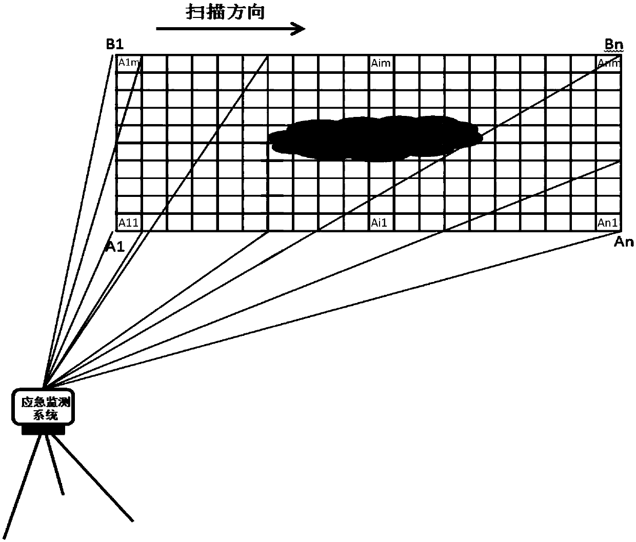
The invention discloses a multi-channel pollution discharge emergency telemetering imaging system. An optical introducing unit is used for synchronously acquiring visible images, ultraviolet spectra,laser ranging, and infrared thermal imaging. An ultraviolet spectrum acquisition system is configured to receive data from the optical introducing unit and transmit the data information to a high-resolution spectrometer through multi-beam optical fibers. The high-resolution spectrometer images received atmospheric scattered light on a CCD detector by grating spectrometry; and after analog-to-digital conversion, a computer carries out spectral processing. The optical introducing unit and the ultraviolet spectrum acquisition system are arranged on a high-precision scanning platform. The high-precision scanning platform is a rotating platform equipped with a stepping motor and an azimuth adjusting motor and is used for adjusting an elevation angle and an azimuthal angle according to targets in different directions and at different heights. Therefore, rapid and multi-component telemetering of sudden discharging of the pollution events is realized; and the two-dimensional distribution condition with the spatial resolution of the polluted gas is obtained.

Description

technical field [0001] The invention relates to the field of optical remote sensing measurement, in particular to a multi-channel pollution discharge emergency telemetry imaging system and method. Background technique [0002] An important issue in air quality monitoring and emergency response to pollution incidents is to obtain the spatial distribution information of polluted gases quickly and with high resolution, and to quickly and accurately obtain the earth with more motor vehicle emissions, elevated source emissions, or complex terrain structures. The two-dimensional spatial distribution information of low-level pollutant gases is even more challenging. [0003] At present, the main methods for remotely measuring the concentration level and vertical distribution of low-level pollutant gases are: laser radar technology, passive Fourier transform technology, passive differential absorption spectroscopy technology, etc. Lidar technology is limited by the wavelength of th...

Claims


Application Information

Patent Timeline
Patent Type & Authority Applications(China)
IPC IPC(8): G01N21/33G01N21/84G01N25/00G01S17/08
CPCG01N21/33G01N21/84G01N25/00G01S17/08
Inventor 徐晋谢品华李昂刘文清张英华吴子扬张强
Owner HEFEI INSTITUTES OF PHYSICAL SCIENCE - CHINESE ACAD OF SCI
Learn More