
Remote radar calibration satellite system and calibration method thereof

A satellite system and calibration technology, applied in the field of radar calibration, can solve the problems of difficult organization and coordination, limited effect of dynamic calibration, complicated organization process, etc. Effect

Active Publication Date: 2019-08-20
NO 63921 UNIT OF PLA
View PDF4 Cites 7 Cited by
  • Summary
  • Abstract
  • Description
  • Claims
  • Application Information

AI Technical Summary

Problems solved by technology

The calibration tower is generally built several kilometers away from the equipment; the distance between the aircraft and the equipment is generally within a hundred kilometers due to flight height restrictions during calibration; the RCS calibration ball that is released can only reach a distance of tens of kilometers. The equipment is in the blind area of ​​the long-range radar
[0009] Second, the effect of dynamic calibration is limited
[0010] Third, it cannot meet the needs of motorized equipment calibration
It is impossible to meet the calibration needs of mobile equipment in different mobile positions by building calibration towers
In addition, in order to meet the requirements of equipment far-field calibration and calibration elevation angle, the construction scale and cost of calibration towers are getting larger and larger. After exceeding a certain scale, it no longer has the technical feasibility and economic feasibility of construction.
[0011] Fourth, it is unable to provide foreign station services
Aircraft flight calibration can only be carried out in China, and it needs to rely on domestic airports and flight troops. The aircraft calibration method cannot provide equipment inspection and appraisal services for foreign stations and ocean-going survey ships.
[0012] Fifth, the organization and implementation are complex
Aircraft flight calibration and standard calibration ball release are all constrained by factors such as weather, management, coordination, site selection, and comprehensive support. The organization process is complicated, and organization and coordination are difficult. It is difficult to complete the calibration flight activities according to the scheduled time node.

Method used


Image

  • Remote radar calibration satellite system and calibration method thereof
  • Remote radar calibration satellite system and calibration method thereof
  • Remote radar calibration satellite system and calibration method thereof

Examples


Embodiment Construction

[0036] Hereinafter, the present invention will be described in detail based on the drawings.

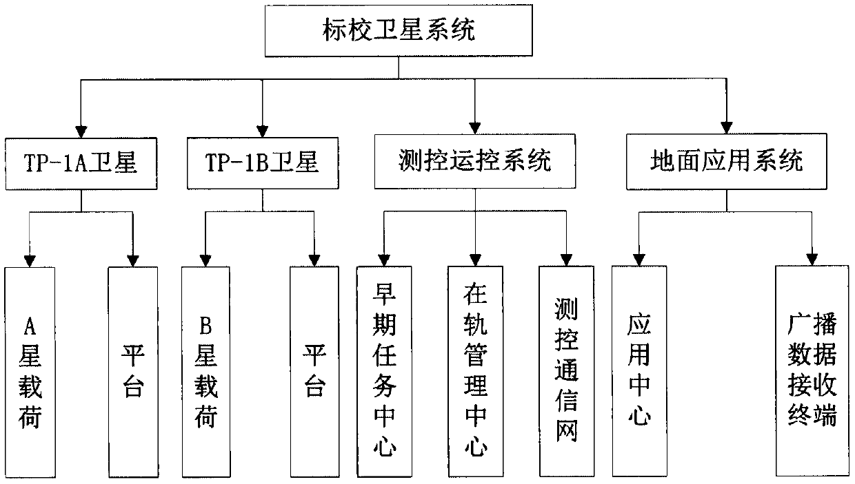
[0037] Such as figure 1 As shown, the present invention designs a long-range radar calibration satellite system, which mainly includes: a measurement and control operation control center, a ground application system, and calibration satellites. The calibration satellites include a reflective radar calibration satellite and a responsive measurement and control equipment calibration satellite. Two satellites are used, one is a reflective radar calibration satellite, and the other is a responsive measurement and control equipment calibration satellite. High-power reflective radar and responsive measurement and control equipment provide calibration services, make full use of existing technical resources, meet the calibration needs of users to the greatest extent, and actively expand the application range of calibration satellites.

[0038] The measurement, control and operation control ce...


PUM


Abstract

The invention relates to a remote radar calibration satellite system, which comprises a measurement and control operation control center, a ground application system, a reflective radar calibration satellite and a responsive measurement and control device calibration satellite, wherein the measurement and control operation control center is used for completing satellite launching and early orbitalsection measurement and control tasks, long-term operation section measurement and control management and load data receiving tasks; the ground application system is used for calibration satellite service planning, precision orbit data processing and publishing of a precision satellite orbit for each user; the reflective radar calibration satellite provides an RCS reference and a precise positionreference for calibration of a ground reflection-type radar device; and the responsive measurement and control device calibration satellite provides a precise position reference for calibration of aground response-type measurement and control device. The existing technical resources can be thoroughly used, the calibration requirements of the user can be met to the maximum degree, and the application range of the calibration satellite is expanded actively.

Description

technical field [0001] The present invention generally relates to the technical field of radar calibration. More specifically, the present invention relates to a long-range radar calibration satellite system and a calibration method thereof. Background technique [0002] Calibration satellites will establish space-based target scattering characteristics benchmarks and target motion state benchmarks, provide services for ground detection equipment calibration and appraisal, and provide support for detection technology research and verification. [0003] The benchmark of target scattering characteristics includes narrowband radar scattering characteristics and wideband radar scattering characteristics. The main characterization of narrowband radar scattering characteristics is radar cross section (RCS). RCS reflects the overall target's ability to scatter radar electromagnetic waves, and is the most basic target characteristic measurement parameter. Broadband radar scatterin...

Claims


Application Information

Patent Timeline
Patent Type & Authority Applications(China)
IPC IPC(8): G01S7/40
CPCG01S7/40
Inventor 吴正容王青伟杨萍慈颖
Owner NO 63921 UNIT OF PLA
Learn More