
A Calculation Method of Deposit Depth of Debris Flow Channel Based on Borehole Data

A technology of depth calculation and drilling data, applied in calculation, data processing application, computer-aided design, etc., can solve the problems of inability to improve the control accuracy of debris flow geological disasters and disaster initiative, and achieve easy calculation results, strong objectivity, Calculating Targeted Performance

Active Publication Date: 2022-04-22
CHENGDU UNIVERSITY OF TECHNOLOGY
View PDF6 Cites 0 Cited by
  • Summary
  • Abstract
  • Description
  • Claims
  • Application Information

AI Technical Summary

Problems solved by technology

[0005] In order to solve the problems existing in the prior art, the present invention provides a method for calculating the sedimentation depth of debris flow channels based on drilling data, which solves the problem that the previous methods cannot improve the control accuracy of debris flow geological disasters and the initiative to deal with disasters

Method used


Image

  • A Calculation Method of Deposit Depth of Debris Flow Channel Based on Borehole Data
  • A Calculation Method of Deposit Depth of Debris Flow Channel Based on Borehole Data
  • A Calculation Method of Deposit Depth of Debris Flow Channel Based on Borehole Data

Examples


Embodiment 1

[0048] Using the present invention to analyze the Gaojiagou in the Wenchuan strong earthquake area, and calculate the deposition depth at different positions of the debris flow channel:

[0049] Wenchuan County is located in the southeast of Aba Autonomous Prefecture in the Sichuan Basin, with a longitude and latitude of 30°45′-31°43′ north latitude and 102°51′-103°44′ east longitude, with a total area of ​​about 4084 square kilometers. The Longmen Mountains and Qionglai Mountains are well developed in the area, high in the northwest and low in the southeast, in a sloping shape, with undulating terrain and large height differences. It is a typical alpine and canyon terrain. In the area, there are the main stream of the Minjiang River, Zagunao River and Yuzixi River, which are tributaries of the Minjiang River. In the basin, Maowen fault and Beichuan-Yingxiu fault are developed.

[0050] Obtain the longitudinal gradient S of the debris flow channel in the Gaojiagou watershed th...

Embodiment 2

[0058] Adopt the present invention to analyze the Panda Ditch (Wolong) in the strong earthquake area of ​​Wenchuan, and calculate the sedimentation depth at different positions of the debris flow ditch:

[0059] Wenchuan County is located in the northwest of the Sichuan Basin, in the southeast of Aba Tibetan Autonomous Prefecture, 146km from the provincial capital Chengdu in the south, and 246km from the state capital of Malkang in the north. The county is 84km wide from east to west, 105km long from north to south, with a total area of ​​4084km2. It is bounded between 30°45′37″~31°43′10″ north latitude and 102°51′46″~103°44′37″ east longitude. Wolong Special Administrative Region is located in the southwest corner of Wenchuan County, bordering Baoxing County to the west, Li County to the north, Lushan and Dayi to the south, Caopo Township to the northeast, Yingxiu Township to the east, and Sanjiang Township to the southeast. Wolong Town now has convenient transportation. Pro...


PUM


Abstract

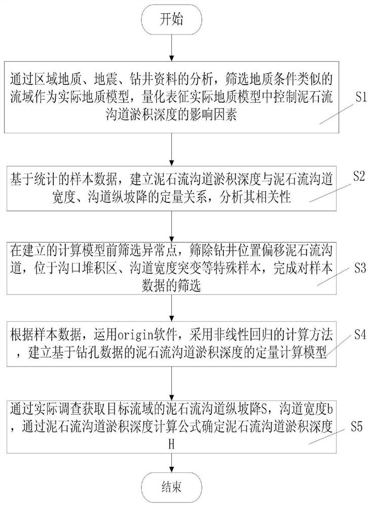
The invention discloses a method for calculating the sedimentation depth of a debris flow channel based on drilling data, which includes the following steps: S1: through the analysis of regional geology, seismic, and drilling data, the watershed with geological conditions is selected as the actual geological model, and the actual geological model is quantitatively represented Influencing factors controlling the sedimentation depth of the debris flow channel in the model; S2: Based on the statistical sample data, establish the quantitative relationship between the sedimentation depth of the debris flow channel, the width of the debris flow channel, and the vertical slope of the channel, and analyze their correlation; S3: After establishing The abnormal points are screened before the calculation model, and the special samples such as the mud-rock flow channel with the drilling position offset, the accumulation area at the mouth of the ditch, and the sudden change of the channel width are screened out to complete the screening of the sample data; this method solves the problem that the previous methods cannot improve the geological Disaster control accuracy and the initiative to deal with disasters.

Description

technical field [0001] The invention relates to the field of geological disaster prevention and control engineering, in particular to a method for calculating the deposition depth of debris flow channels based on drilling data. Background technique [0002] After the "5.12" Wenchuan Earthquake, the critical rainfall intensity that induced geological disasters of landslides, landslides, and debris flows was greatly reduced, resulting in more frequent geological disasters of landslides and landslides, and a large number of sources accumulated in the trenches of the debris flow basin, which intensified the activities of debris flows. Debris flows mainly develop on mountain slopes or in valleys, and are composed of a large amount of sediment, stones and water, and are a complex solid-liquid two-phase fluid. The interaction of solids and fluids not only makes the flow of matter physically distinguishable, but also endows them with unique destructive forces. Debris flow is one of...

Claims


Application Information

Patent Timeline
Patent Type & Authority Patents(China)
IPC IPC(8): G06F30/00G06Q10/04G06Q50/26
CPCG06Q10/04G06Q50/26G06F30/00
Inventor 唐川罗玉婷龚凌枫李宁贴宇史青云
Owner CHENGDU UNIVERSITY OF TECHNOLOGY
Learn More