A GNSS occultation ionospheric residual correction method, system, equipment and storage medium

An ionospheric residual and ionospheric technology, which is applied in satellite radio beacon positioning systems, radio wave measurement systems, instruments, etc., can solve the influence of bending angle ionospheric residuals without considering the electron density distribution of a single occultation event , poor reliability and accuracy, etc., to achieve the effect of weakening the impact, improving accuracy and high precision

Active Publication Date: 2021-01-08
NAT SPACE SCI CENT CAS
View PDF14 Cites 0 Cited by
  • Summary
  • Abstract
  • Description
  • Claims
  • Application Information

AI Technical Summary

Problems solved by technology

At present, the more advanced Kappa correction method is based on the assumption of neutral atmosphere and spherical symmetry of the ionosphere, without considering the specific distribution of electron density along the signal path of a single occultation event and the influence of the geomagnetic field on the ionosphere residual of the bending angle, and its reliability and less accurate
[0004] To sum up, the bending angle ionospheric residual is the main factor that restricts the high-precision inversion of GNSS occultation data in the 25–60 km altitude range; the existing bending angle ionospheric residual correction method is based on the neutral atmosphere and ionospheric symmetry Assumption, ignores the influence of uneven distribution of electron density along the occultation signal path and the influence of the geomagnetic field, and is a simple statistical empirical model, its reliability and accuracy are poor

Method used


Image

  • A GNSS occultation ionospheric residual correction method, system, equipment and storage medium
  • A GNSS occultation ionospheric residual correction method, system, equipment and storage medium
  • A GNSS occultation ionospheric residual correction method, system, equipment and storage medium

Examples


Embodiment 1

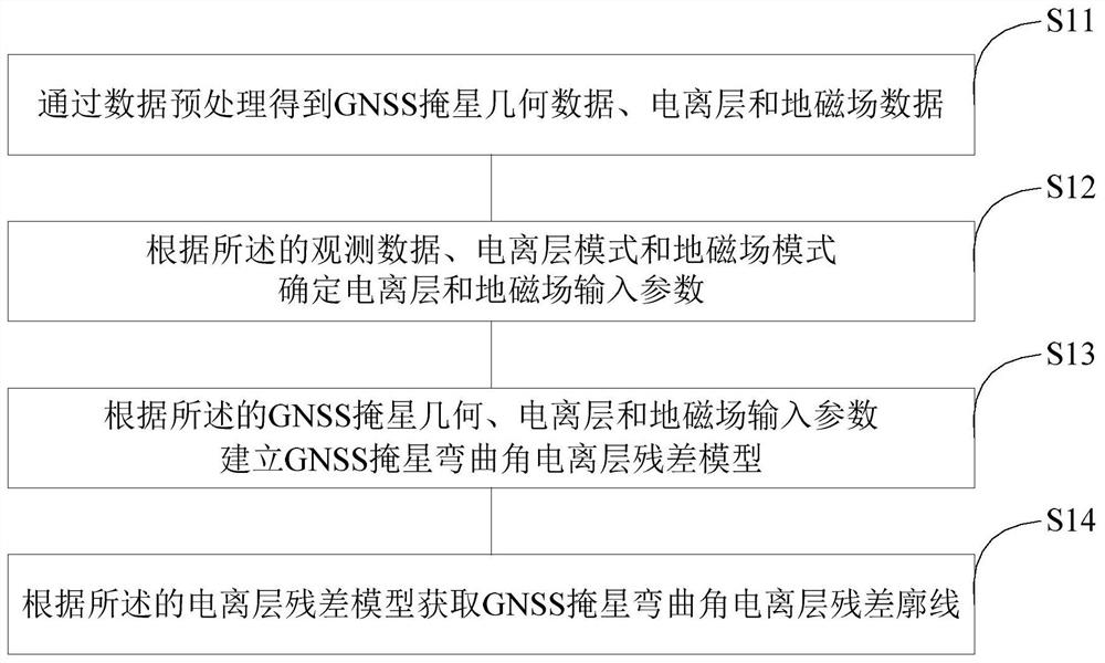
[0051] like figure 1 As shown, embodiment 1 of the present invention proposes a kind of GNSS occultation ionospheric residual correction method, this method takes into account the influence of ionosphere and geomagnetic field, and this method comprises the following steps:

[0052] S11. Obtain GNSS occultation geometric data, ionosphere and geomagnetic field data through data preprocessing;

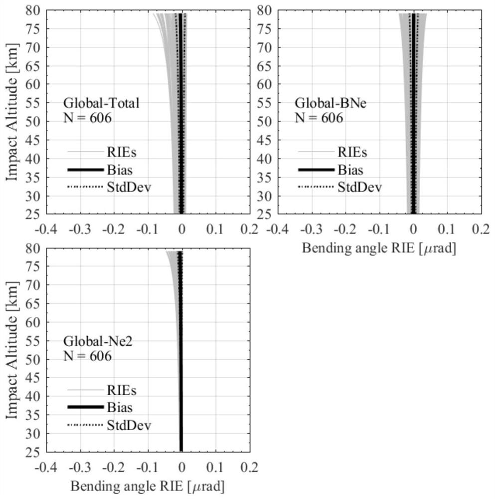
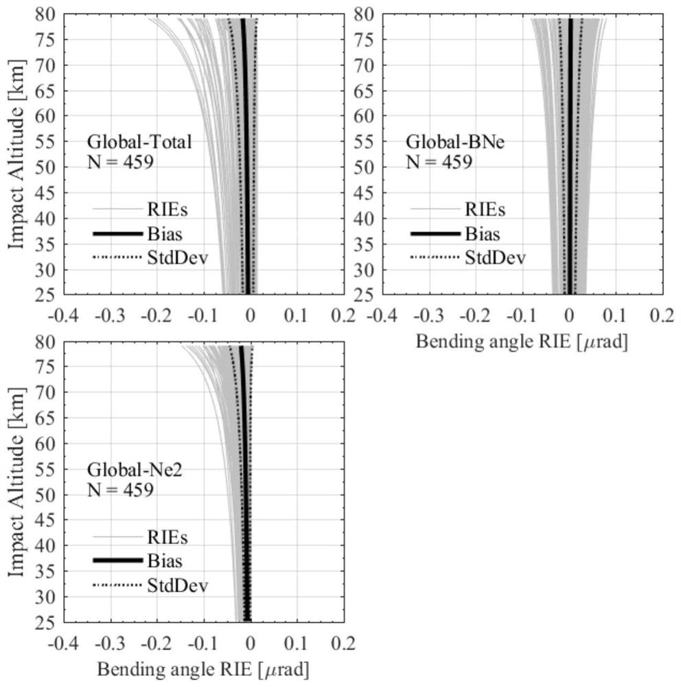
[0053] This embodiment uses GPS / MetOp-A occultation observation data, as well as vTEC maps data released by IGS stations and geomagnetic field data products released by GFZ for data processing. The basic input parameters of the bending angle ionospheric residual correction model are shown in Table 1 :

[0054] Table 1 Basic input parameters of the bending angle ionospheric residual correction model

[0055]

[0056] S12, according to the pre-processing GNSS occultation geometry, ionosphere and geomagnetic field data, combined with ionosphere and geomagnetic field mode to determine io...

Embodiment 2

[0084] Embodiment 2 of the present invention proposes a GNSS occultation ionospheric residual error correction system, which includes:

[0085] The preprocessing module preprocesses the original GNSS occultation observation data, vTEC maps data and geomagnetic field observation data to obtain GNSS occultation geometric data, ionospheric data and geomagnetic field data;

[0086] The electron density calculation module is used to calculate the electron density profile at the position of the ionospheric puncture point on the "incoming ray" and "outgoing ray" sides based on GNSS occultation geometric data, three-dimensional NeUoG ionospheric model and ionospheric data;

[0087] The geomagnetic strength calculation module is used to calculate the geomagnetic field strength profile along the signal path at the position of the ionospheric puncture point on the "incoming ray" and "outgoing ray" sides based on GNSS occultation geometric data, IGRF geomagnetic field model and geomagnetic...

Embodiment 3

[0090] Embodiment 3 of the present invention provides a computer device, including a memory, a processor, and a computer program stored on the memory and operable on the processor. When the processor executes the computer program, the computer program is implemented. Example 1 method.


PUM


Abstract

The invention provides a GNSS occultation ionospheric residual correction method and system, a device and a storage medium. The method comprises the steps of: preprocessing GNSS occultation original observation data, vTEC maps data and geomagnetic field observation data to obtain GNSS occultation geometric data, ionospheric data and geomagnetic field data; based on the GNSS occultation geometric data, a three-dimensional NeUoG ionospheric mode and the ionospheric data, calculating an electron density profile at the location of an ionospheric puncture point on an incident ray side and an emergent ray side; based on the GNSS occultation geometric data, an IGRF geomagnetic field mode and the geomagnetic field data, calculating a geomagnetic field intensity profile along a signal path at the location of the ionospheric puncture point on the incident ray side and the emergent ray side; based on the electron density and the geomagnetic field intensity along the signal path, calculating a bending angle ionospheric residual profile. The method of the invention can be used in the atmospheric parameter inversion of a single GNSS occultation event, weakens the influence of the ionospheric residual, obtains a high-precision GNSS occultation curved angular profile, and is efficient and reliable.

Description

technical field [0001] The application of the present invention relates to the field of GNSS radio occultation atmospheric detection technology and meteorology, in particular to a GNSS occultation ionospheric residual error correction method, system equipment and storage medium. Background technique [0002] GNSS occultation detection technology can obtain vertical profiles of physical parameters such as high vertical resolution, high precision, no calibration, long-term stability, and all-weather physical parameters such as atmospheric refractive index, density, temperature, humidity, and pressure. GNSS occultation data have been used in climate analysis and medium-term numerical weather prediction on a twenty-year scale. However, as the altitude rises, the influence of the ionosphere becomes greater and the accuracy of the retrieved atmospheric parameters gradually decreases. The accuracy of occultation data at the top of the stratosphere and the bottom of the mesosphere (...

Claims


Application Information

Patent Timeline
Patent Type & Authority Patents(China)
IPC IPC(8): G01S19/07G01W1/00
CPCG01S19/07G01W1/00
Inventor 柳聪亮孙越强杜起飞白伟华王先毅蔡跃荣孟祥广夏俊明王冬伟李伟吴春俊刘成赵丹阳
Owner NAT SPACE SCI CENT CAS
Why Eureka
Try Eureka