Bayesian soil moisture estimation method based on multi-source remote sensing data
A technology for soil moisture and remote sensing data, applied in electrical digital data processing, special data processing applications, calculations, etc., can solve the problems of low spatial resolution of passive microwave satellites and complicated verification of SM products.
- Summary
- Abstract
- Description
- Claims
- Application Information
AI Technical Summary
Problems solved by technology
Method used
Image
Examples
Embodiment Construction
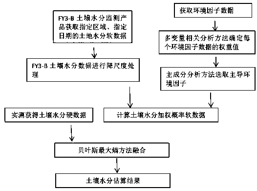
[0039] The purpose of this study is to estimate higher resolution and higher precision SM by integrating multi-source remote sensing data into the BME algorithm, and the process method is schematically shown in the attached figure 1 As shown, the specific examples are as follows:
[0040] 1. Hard data preparation
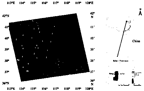
[0041] study area ( figure 2 ) in Hengshui City, Hebei Province, in Northwest China (38°3'00"N, 115°27'54"E). This is a typical agricultural area with only a few types of land cover (bare soil, corn, orchard, and grass) with a uniform soil texture. The region has a typical continental monsoon climate, with high temperatures and abundant rainfall in summer and cold and dry winters. Therefore, SM content plays an important role in agricultural production, especially in summer. To measure SM content, field experiments were carried out in summer. Sample points such as figure 2 shown. Corn, cotton, and peanuts are the main crops at these sites. The main soil t...
PUM
 Abstract
Description
Claims
Application Information
 - R&D
- Intellectual Property
- Life Sciences
- Materials
- Tech Scout
- Unparalleled Data Quality
- Higher Quality Content
- 60% Fewer Hallucinations
Browse by: Latest US Patents, China's latest patents, Technical Efficacy Thesaurus, Application Domain, Technology Topic, Popular Technical Reports.
© 2025 PatSnap. All rights reserved.Legal|Privacy policy|Modern Slavery Act Transparency Statement|Sitemap|About US| Contact US: help@patsnap.com


