High-precision positioning method of mobile robot along subway track

A mobile robot, positioning method technology, applied in the directions of instruments, navigation, mapping and navigation, can solve problems such as poor positioning accuracy and reliability, positioning accuracy problems, and achieve the effect of solving poor positioning accuracy and reliability

Active Publication Date: 2020-01-17
WUHAN UNIV +1
View PDF5 Cites 12 Cited by
  • Summary
  • Abstract
  • Description
  • Claims
  • Application Information

AI Technical Summary

Problems solved by technology

[0005] The technology of the present invention overcomes the positioning accuracy problem of the existing unmanned moving robot along the track

Method used


Image

  • High-precision positioning method of mobile robot along subway track
  • High-precision positioning method of mobile robot along subway track
  • High-precision positioning method of mobile robot along subway track

Examples


Embodiment Construction

[0068] In order to make the object, technical solution and advantages of the present invention more clear, the present invention will be described in detail below in conjunction with the accompanying drawings and specific embodiments.

[0069] A high-precision positioning method for moving a robot along a subway track, specifically comprising the following steps:

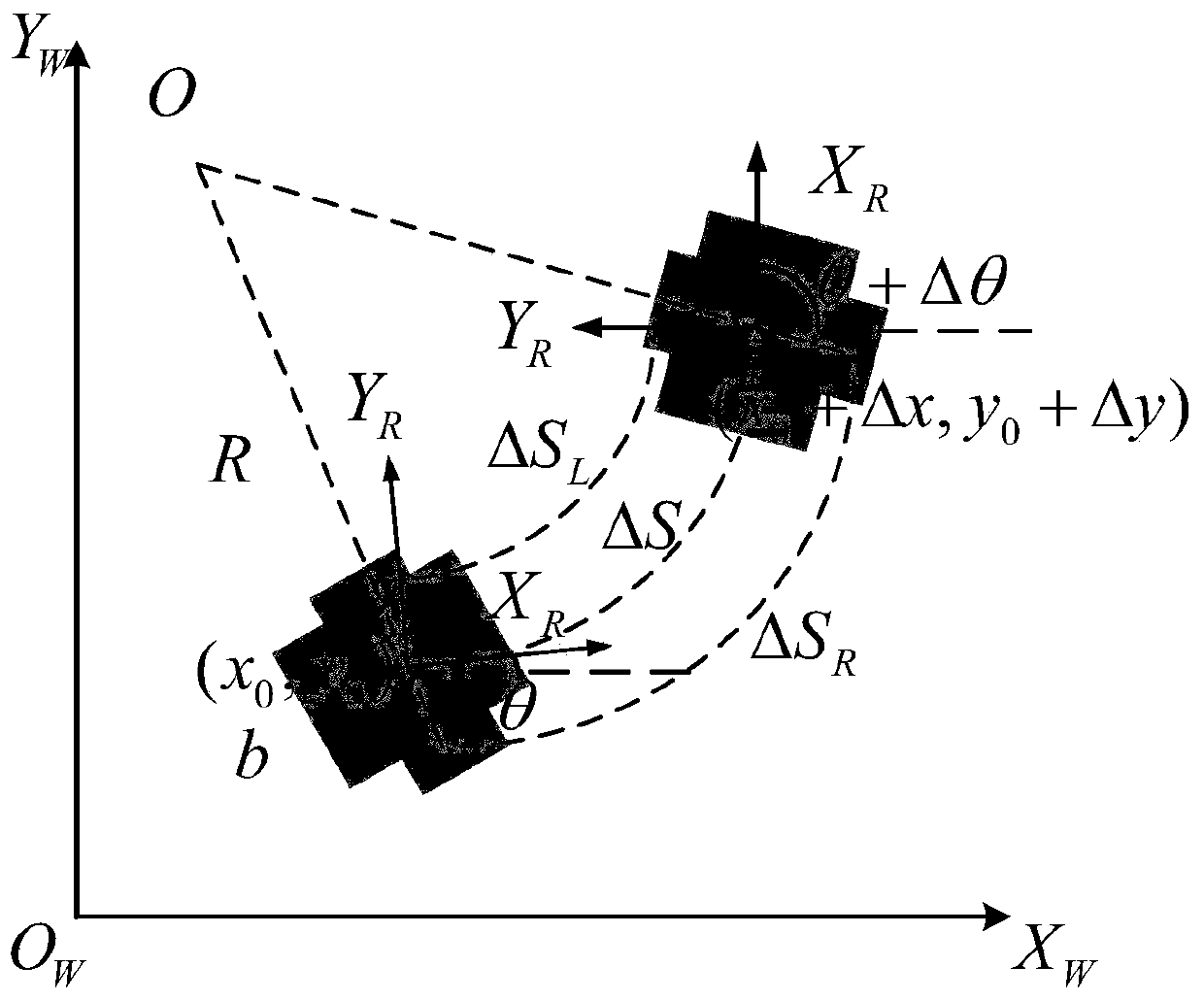
[0070] Step S1: Set the initial pose P of the mobile robot 0 =(x 0 ,y 0 , θ 0 ), reaching the pose point P after ΔT time 1 =(x 0 +Δx,y 0 +Δy,θ 0 +Δθ). where (x 0 ,y 0 ) is the initial pose of the mobile robot, θ 0 is the initial azimuth, that is, the coordinate system X of the mobile robot R The positive direction of the axis and the global coordinate system X W The included angle in the positive direction of the axis, b is the wheel base of the left and right wheels, R is the radius of the moving arc of the mobile robot, ΔS R , ΔS L , ΔS respectively represent the moving distance of the left and right...


PUM


Abstract

The present invention discloses a high-precision positioning method of a mobile robot along a subway track. The method comprises the following steps: performing mobile robot odometer pose estimation,and obtaining robot real-time pose (x1, y1, [theta]); in order to eliminate the accumulated error existed in odometer positioning, realizing a positioning method combining odometer measurement with total station instrument measurement by adopting an extended kalman filter (EKF); establishing a total station instrument CPIII / odometer combination positioning model based on the EKF; and performingmatching and pose updating on total station instrument observation information and odometer status prediction information via the EKF algorithm, and thus realizing periodic correction of the odometeraccumulated error and high-precision positioning of the mobile robot.

Description

technical field [0001] The invention relates to a high-precision positioning method for moving a robot along a subway track. Background technique [0002] With the rapid development of wireless communication, Internet technology and artificial intelligence, positioning technology has received extensive attention. The current positioning technologies mainly include: Global Navigation Satellite System (Global Navigation Satellite System, GNSS), Inertial Navigation System (Inertial Navigation System), laser Radar navigation, visual navigation, etc. These navigation methods can independently complete pose calculation, extraction and estimation. Compared with the traditional GNSS satellite inertial navigation combination method for pose estimation, it is most widely used on outdoor inspection robots or small UAVs. The technology is relatively mature, and the pose estimation accuracy is high. However, GPS satellite signals are easily affected by the environment, and communicatio...

Claims


Application Information

Patent Timeline
IPC IPC(8): G01C21/00G01C21/20
CPCG01C21/005G01C21/20
Inventor 肖晓晖张浩段宝阁邱邵峰陈潇耿明何杰
Owner WUHAN UNIV
Why Eureka
Try Eureka