Remote sensing detection and spatial hot area identification system and method for contaminated site

A technology for identifying systems and sites, applied in scene recognition, heat measurement, character and pattern recognition, etc., can solve problems that cannot meet the application requirements of polluted sites

Active Publication Date: 2020-01-24
INST OF GEOGRAPHICAL SCI & NATURAL RESOURCE RES CAS
View PDF10 Cites 13 Cited by
  • Summary
  • Abstract
  • Description
  • Claims
  • Application Information

AI Technical Summary

Problems solved by technology

However, these invention patents mainly focus on a specific type of contaminated site remediation work or the invention of a contaminated site remediation device. There are few related patents on remote sensing identification of contaminated sites and ...

Method used


Image

  • Remote sensing detection and spatial hot area identification system and method for contaminated site
  • Remote sensing detection and spatial hot area identification system and method for contaminated site
  • Remote sensing detection and spatial hot area identification system and method for contaminated site

Examples


Embodiment Construction

[0070] The present invention will be described in detail below in conjunction with the accompanying drawings and embodiments.

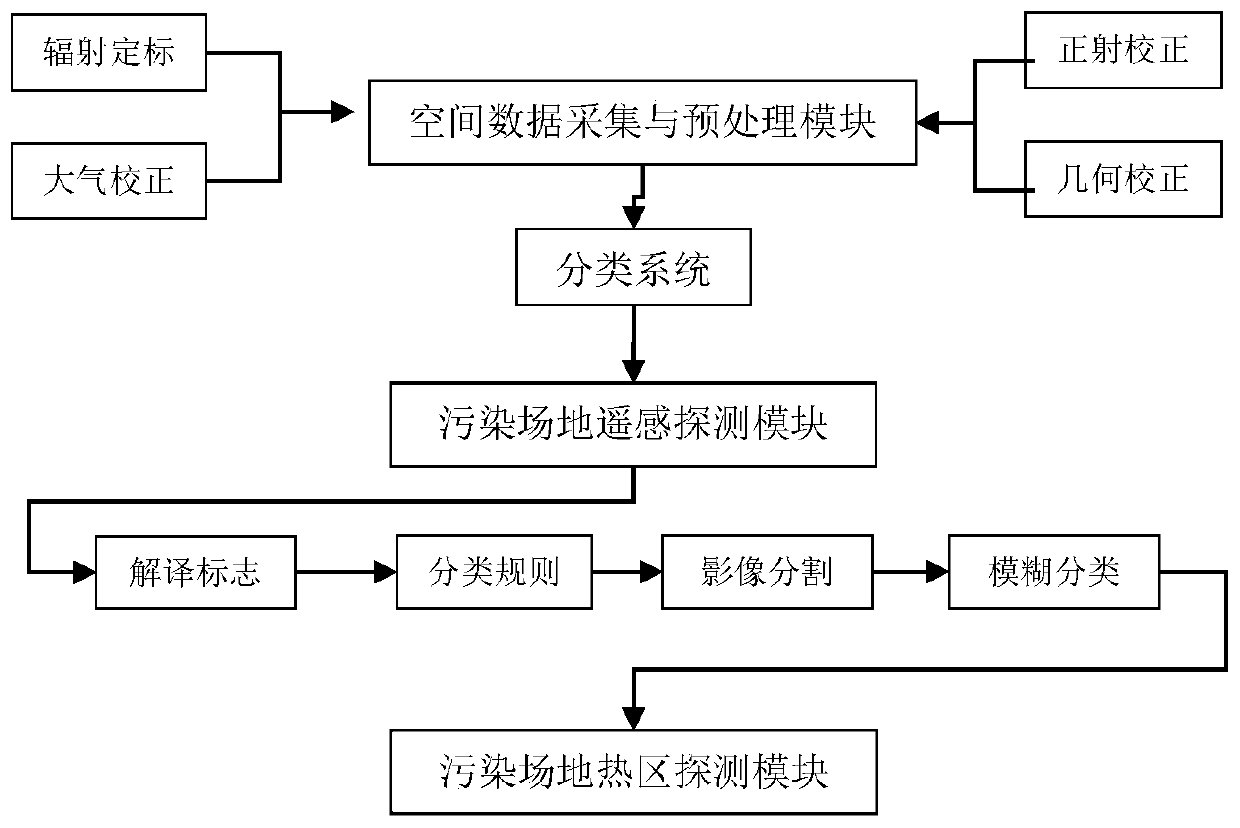
[0071] like figure 1 As shown, the system of the present invention includes a spatial data acquisition and preprocessing module, a polluted site remote sensing detection module, and a polluted site hot zone identification module.

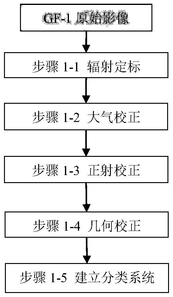
[0072] like figure 2 As shown, the spatial data acquisition and preprocessing module in the present invention is used for spatial data acquisition and preprocessing, including the following steps:

[0073] Step 1-1, perform radiometric correction on the downloaded Gaofen-1 original image; first, open the original remote sensing image with the help of ENVI 5.1 software; then, with the help of the Radiometric Calibration tool, select the image that needs to be radiometrically corrected, and set the calibration form (Calibration Type) is the default Radiance, change the Output Interleave to BIL sequence, the output type def...


PUM


Abstract

The invention discloses a remote sensing detection and spatial hot area identification system and method for a contaminated site. The system comprises a spatial data acquisition and preprocessing module, a contaminated site remote sensing detection module and a contaminated site hot area detection module. The system serves the work of contaminated site monitoring, hot area detection and the like.The system comprises a novel contaminated site remote sensing image detection method framework, and an identification method for a centralized distribution area of the contaminated site is realized. The system has the characteristic of high practicability, and has urgent application requirements in the related fields of current contaminated site situation monitoring, contaminated site planning, ecological environment restoration and the like.

Description

technical field [0001] The invention relates to a polluted site remote sensing detection and space hot area identification system and method, which belongs to the application field of remote sensing and geographic information technology applied in the urban planning and environmental protection industry, and is mainly used in the management of polluted sites, serving for macroscopic monitoring of polluted sites Spatial distribution, detecting concentrated distribution areas of polluted sites, has extensive and urgent application requirements in the fields of polluted site management, surveying and mapping, geographic information, and ecological environment protection. Background technique [0002] In recent years, the polluted site management industry has made great progress in site information collection, pollution investigation and legal construction, but currently a large number of polluted sites are in a high-risk state, and there is still a lack of effective supervision ...

Claims


Application Information

Patent Timeline
IPC IPC(8): G01N21/17G01K11/00G06K9/00G06K9/62
CPCG01N21/17G01K11/00G01N2021/1793G06V20/13G06F18/24
Inventor 匡文慧
Owner INST OF GEOGRAPHICAL SCI & NATURAL RESOURCE RES CAS
Why Eureka
Try Eureka