Regional carbon reserve space pattern monitoring system and method based on remote sensing data

A technology of remote sensing data and spatial pattern, applied in the direction of design optimization/simulation, etc., can solve the problems of long research period of carbon storage in a large area

Active Publication Date: 2020-02-04
南京信大气象科学技术研究院有限公司
View PDF6 Cites 15 Cited by
  • Summary
  • Abstract
  • Description
  • Claims
  • Application Information

AI Technical Summary

Problems solved by technology

[0004] The purpose of the present invention is to provide a monitoring system and method for the spatial pattern of regional carbon storage based on remote sensing data in view of the shortcoming of the long research period of the existing large-scale regional carbon storage, using satellite remote sensing data, using precipitation, vegetation coverage, land surface Temperature, land use data, light data, DEM data and meteorological data to establish a model to monitor the temporal and spatial changes of regional carbon storage

Method used


Image

  • Regional carbon reserve space pattern monitoring system and method based on remote sensing data
  • Regional carbon reserve space pattern monitoring system and method based on remote sensing data
  • Regional carbon reserve space pattern monitoring system and method based on remote sensing data

Examples


Embodiment Construction

[0068] The content of the invention of the present invention will be further described below in conjunction with the accompanying drawings and embodiments.

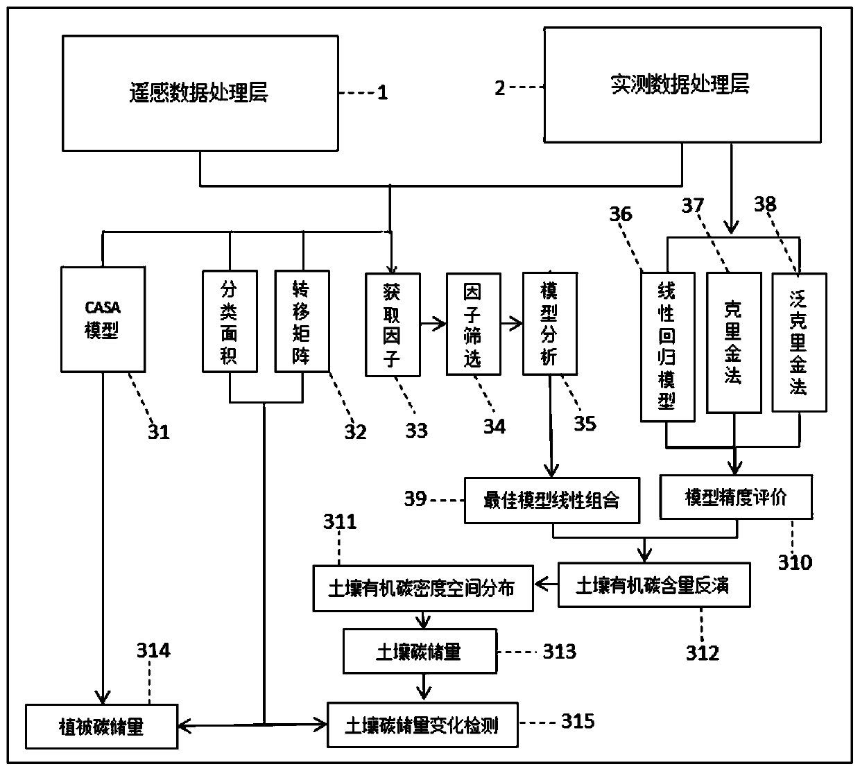
[0069] A remote sensing data-based regional carbon storage spatial pattern monitoring system, including a remote sensing data processing module, a measured data processing module, and a data analysis and output module; wherein, the remote sensing data processing module and the measured data processing module output terminal and data The analysis is connected to the input of the output module;

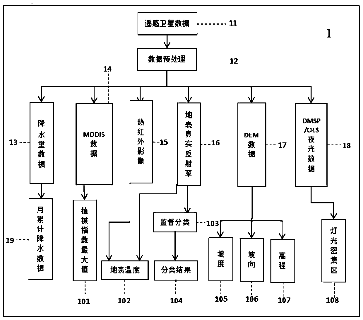
[0070] The remote sensing data processing module is used to obtain and preprocess the data observed by remote sensing satellites within a preset time;

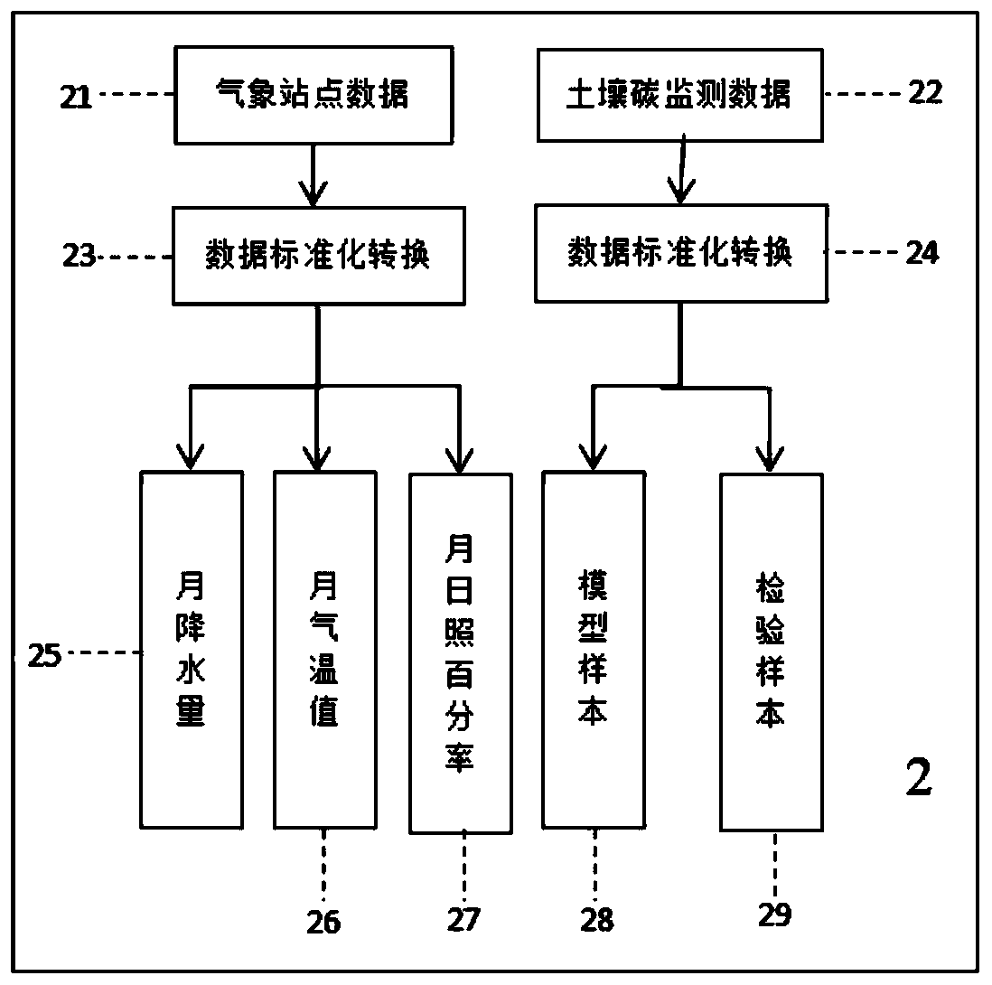
[0071] The measured data processing module is used to obtain weather station data and soil detection data within the preset time and establishes a linear regression model;

[0072] The data analysis and output module is used to determine plant carbon storage and soil carbon storag...


PUM


Abstract

The invention discloses a regional carbon reserve space pattern monitoring system and method based on remote sensing data. The system comprises a remote sensing data processing module, an actual measurement data processing module and a data analysis and output module. The output ends of the remote sensing data processing module and the actual measurement data processing module are connected with the input end of the data analysis and output module; satellite remote sensing data, precipitation, vegetation coverage rate, surface temperature, land utilization data, light data, DEM data and meteorological data are used to establish a model to monitor the spatial-temporal change of regional carbon reserves, and the defect of long research period of large-scale regional carbon reserves is overcome. The monitoring system also has the advantages of easily available source data, high computer operation efficiency, low cost, strong timeliness and the like.

Description

technical field [0001] The invention belongs to the technical field of environmental protection and urban planning, and in particular relates to a remote sensing data-based monitoring system and method for the spatial pattern of regional carbon storage. Background technique [0002] With the rapid development of the economy, urbanization has spread to the periphery of the world's material cultural heritage areas. According to the assessment report of the Intergovernmental Panel on Climate Change (IPCC), at least 1 / 4 of anthropogenic carbon dioxide emissions in the past 20 years was caused by land use change. Therefore, the impact of human activities on the carbon cycle is one of the important core issues in climate change research. In formulating countermeasures to cope with and mitigate climate warming, it is currently proposed to absorb CO through land management. 2 Therefore, accurately determining the impact of land use change on organic carbon pools has important theor...

Claims


Application Information

Patent Timeline
Patent Type & Authority Applications(China)
IPC IPC(8): G06F30/20
Inventor 周鹏薛丰昌苗春生詹少伟周可张越
Owner 南京信大气象科学技术研究院有限公司
Why Eureka
Try Eureka