Method for generating ortho-photo map of narrow and long region of border by digital photogrammetry system

A technology of digital photogrammetry and digital orthophoto, applied in the field of civilian high-scoring digital photogrammetry, can solve problems such as product production difficulties

Inactive Publication Date: 2020-02-07
新疆维吾尔自治区测绘科学研究院
View PDF8 Cites 15 Cited by
  • Summary
  • Abstract
  • Description
  • Claims
  • Application Information

AI Technical Summary

Problems solved by technology

[0004] The purpose of the present invention is to solve the problems of difficult production of DOM products in the long and narrow border area, and proposes a method for generating an orthophoto map of the long and narrow border area by a digital photogrammetry system

Method used


Image

  • Method for generating ortho-photo map of narrow and long region of border by digital photogrammetry system
  • Method for generating ortho-photo map of narrow and long region of border by digital photogrammetry system
  • Method for generating ortho-photo map of narrow and long region of border by digital photogrammetry system

Examples


Embodiment Construction

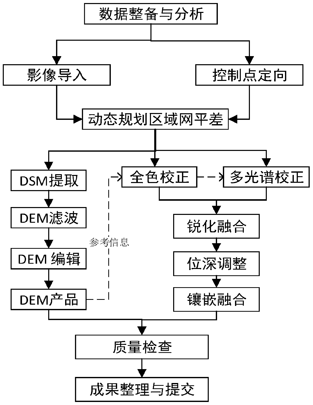
[0074] In order to make the object, technical solution and advantages of the present invention clearer, the present invention will be further described in detail below in conjunction with the accompanying drawings and embodiments. It should be understood that the specific embodiments described here are only used to explain the present invention, not to limit the present invention.

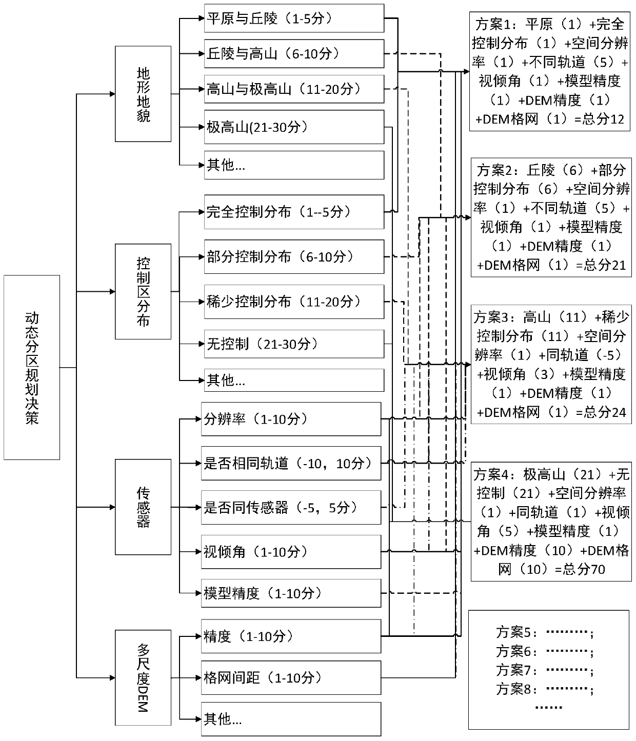
[0075] see figure 1 , figure 2 and image 3 , the method for digital photogrammetry system to generate an orthophoto map of a long and narrow border area, the specific steps are as follows:

[0076](1) Data preparation and analysis:

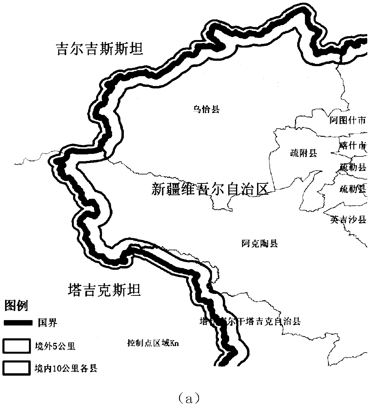
[0077] Collect data from the mission area. The scope of the mission area is 5 kilometers within a certain section of the border of the Xinjiang Autonomous Region and 10 kilometers outside the border. For details, see image 3 -a. Analyze and check the validity of the data; the data includes high-resolution remote sensing stereo image pair data, satellite RPC (R...


PUM


Abstract

The invention discloses a method for generating an ortho-photo map of a narrow and long region of a border by a digital photogrammetry system. The method comprises the following steps of (1) preparingand analyzing data; (2) dynamically planning block adjustment; (3) extracting digital surface model data; (4) generating digital elevation model data; (5) performing quality inspection; (6) generating a digital orthoimage; and (7) evaluating the quality of a digital orthoimage product, and generating digital orthoimage product regulations with processes conforming to the national and industry standards. By adopting the method, the precision of the generated digital orthoimage can meet the precision requirements of level-3 products with the scales of 1:10,000 in the national standards minimally, a high-precision, efficient and high-universality digital orthoimage production process is realized, and an innovative technical method is provided for digital mapping work of the narrow and long region of the uncontrolled or less-controlled border.

Description

technical field [0001] The invention belongs to the technical field of civilian high-resolution digital photogrammetry, and in particular relates to a method for generating an orthophoto map of a long and narrow border area by a digital photogrammetry system. Background technique [0002] China's inland border is long and narrow, and its special natural environment, climatic conditions and other sensitive factors make it an important area for national defense construction and frontier stability maintenance. The border line is irregular and long, disasters occur frequently in the area, the terrain is complex, there are no control points outside the border, and it is difficult to obtain control points in uninhabited areas. There are many problems in the production process of large-scale digital orthophoto (DOM) Difficulties, the use of conventional aerial photogrammetry operations is limited. With the continuous improvement of the spatial resolution of stereo surveying and ma...

Claims


Application Information

Patent Timeline
Patent Type & Authority Applications(China)
IPC IPC(8): G01C11/34G01C11/04G06T5/00G06T5/50G06T11/20
CPCG01C11/04G01C11/34G06T5/003G06T5/50G06T11/206G06T2207/10036G06T2207/10041G06T2207/20221
Inventor 刘涛翟亮李娜娜张琴琴薛磊李争光马静顾芳詹亮陶兰花何芷曾海燕李鸿飞
Owner 新疆维吾尔自治区测绘科学研究院
Why Eureka
Try Eureka