
Distributed relative navigation method oriented to multi-aircraft collaborative formation flying

A technology of formation flight and relative navigation, which is applied in the field of distributed relative navigation of multi-aircraft cooperative formation flight, can solve the problems of unreliability, inability to work alone, low frequency of data collection, etc., to reduce position and speed errors, enhance Anti-jamming ability and the effect of improving navigation accuracy

Active Publication Date: 2020-02-28
CHINESE AERONAUTICAL RADIO ELECTRONICS RES INST
View PDF3 Cites 5 Cited by
  • Summary
  • Abstract
  • Description
  • Claims
  • Application Information

AI Technical Summary

Problems solved by technology

[0004] GPS is a satellite navigation and positioning system developed by the U.S. Department of Defense for sea, land, and air. It has the advantages of globalization, all-weather, and three-dimensional positioning. low and is a non-autonomous system
SINS (Strapdown Inertial Navigation System) is a more commonly used inertial navigation method. It uses inertial components to measure the acceleration of the moving carrier and calculate the navigation parameters. It is completely autonomous, free from interference from the external environment, and has no signal loss. , multifunctional, its navigation accuracy mainly depends on the gyroscope and accelerometer, but traditional inertial devices are generally large in size and high in cost, while MEMS inertial sensors have the characteristics of small size, low cost and light weight, but their system The accuracy is low, if the system error is large if used directly, it cannot work alone
[0005] Modern navigation technology has developed into an integrated navigation system composed of various types of sensors. The integrated navigation system overcomes the shortcomings of single sensor uncertainty and unreliability through the cooperation of various sensors and the use of data fusion algorithms.

Method used


Image

  • Distributed relative navigation method oriented to multi-aircraft collaborative formation flying
  • Distributed relative navigation method oriented to multi-aircraft collaborative formation flying
  • Distributed relative navigation method oriented to multi-aircraft collaborative formation flying

Examples


Embodiment Construction

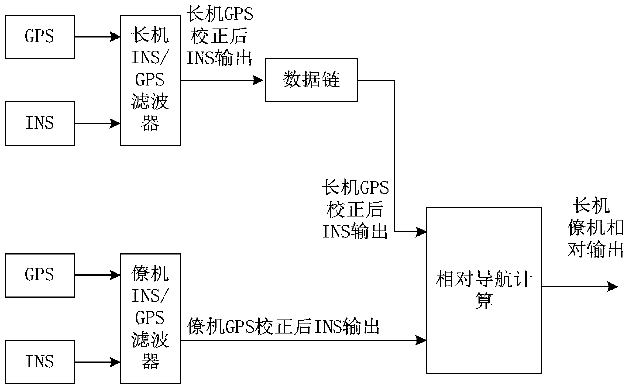
[0039] This embodiment provides a distributed relative navigation system for multiple aircraft to fly in a coordinated formation, where the multiple aircraft include at least one leader and at least one wingman, and all use an integrated navigation system for navigation.

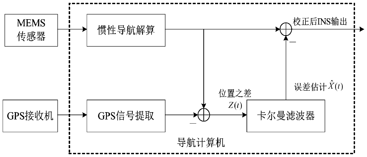
[0040] figure 2 The INS / GPS integrated navigation system of the lead plane and the wingman of this embodiment; such as figure 1 As shown, the integrated navigation system of this embodiment includes a MEMS-SINS navigation system, a GPS navigation system, a Kalman filter and a navigation computer.

[0041] The MEMS-SINS navigation system uses MEMS sensors to obtain the initial reference position and velocity information of the MEMS-SINS navigation system through the initial alignment of the MEMS sensors. In the system startup stage, the initial alignment of the attitude angle is carried out through the magnetic compass, the real-time attitude angle of the system is obtained by recursing the gyro data throug...


PUM


Abstract

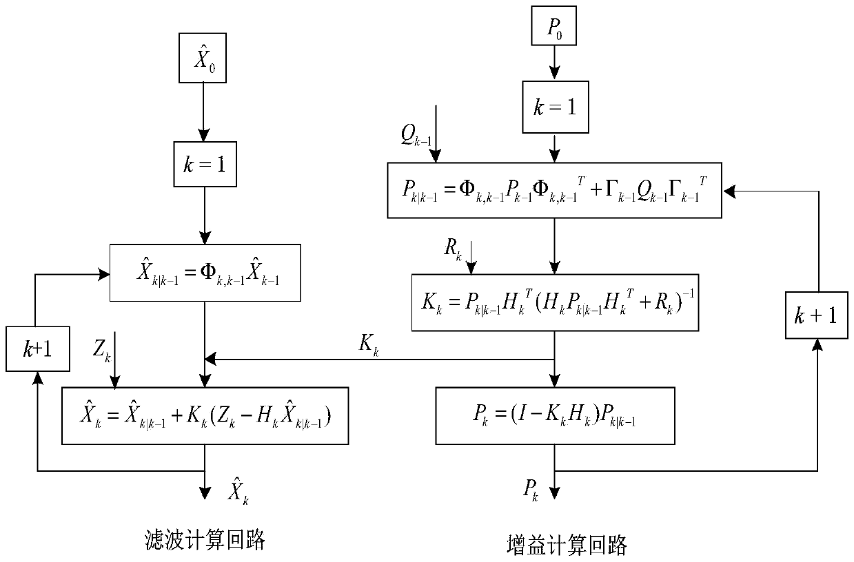
The invention belongs to the technical field of multi-aircraft collaborative formation flying, and provides a distributed relative navigation method oriented to multi-airplane collaborative formationflying. A MEMS-SINS navigation system and a GPS navigation system of a lead aircraft respectively output INS data and GPS data of the lead aircraft, the INS data and the GPS data of the lead aircraftare subjected to Kalman filtering processing to obtain INS output data of the lead aircraft after GPS correction, and the INS output data is fed back to a wing aircraft through a data chain; an MEMS-SINS navigation system and a GPS navigation system of a wing aircraft respectively output INS data and GPS data of the wing aircraft, and the INS data and the GPS data of the wing aircraft are subjected to Kalman filtering treatment to obtain INS output data of the wing aircraft after GPS correction; the INS output data of the lead aircraft and the wing aircraft after GPS correction is subjected torelative navigation calculation to obtain relative distance and relative position of the lead aircraft and the wing aircraft. The obtained relative distance and relative position can be provided fora multi-aircraft collaborative formation flying system in real time, thereby providing more accurate data source for realizing the formation aggregation, formation maintenance and reconstruction and like functions.

Description

technical field [0001] The invention belongs to the technical field of multi-aircraft cooperative formation flight, and particularly relates to a distributed relative navigation method for multi-aircraft cooperative formation flight. [0002] technical background [0003] In order to meet the mission requirements, multiple aircraft perform certain formation arrangement and task assignment, including trajectory planning, formation design, relative navigation, formation control and formation reconfiguration. In the coordinated formation flight of the fleet, it is a prerequisite for the formation control and formation to accurately estimate the relative positions among the members and the relative and absolute positions of the members in real time. An important way to obtain absolute information has received extensive attention. [0004] GPS is a satellite navigation and positioning system developed by the US Department of Defense for sea, land and air. It has the advantages of...

Claims


Application Information

Patent Timeline
IPC IPC(8): G01C21/16G01C21/20G01S19/47G05D1/10
CPCG01C21/165G01C21/20G01S19/47G05D1/104Y02T90/00
Inventor 候建永金古烃魏春燕邢冬静甑子洋
Owner CHINESE AERONAUTICAL RADIO ELECTRONICS RES INST
Learn More