Unmanned aerial vehicle autonomous flight method for constructing three-dimensional real scene based on LiDAR data

A drone and three-dimensional technology, applied in 3D modeling, image data processing, three-dimensional position/channel control, etc., can solve the problems of high safety hazards, low patrol efficiency, redundant staffing, etc. , to achieve the effect of preventing UAV from crashing, solving low efficiency and improving operation quality

Pending Publication Date: 2020-03-17
杨扬
View PDF5 Cites 19 Cited by
  • Summary
  • Abstract
  • Description
  • Claims
  • Application Information

AI Technical Summary

Problems solved by technology

[0005] The purpose of the embodiments of the present invention is to provide a UAV autonomous flight method based on LiDAR data to construct a three-dimensional real scene, so as to solve the problems of the existing UAV line inspection, such as high safety hazards, low line inspection efficiency, and redundant staffing.

Method used


Image

  • Unmanned aerial vehicle autonomous flight method for constructing three-dimensional real scene based on LiDAR data

Examples


Embodiment

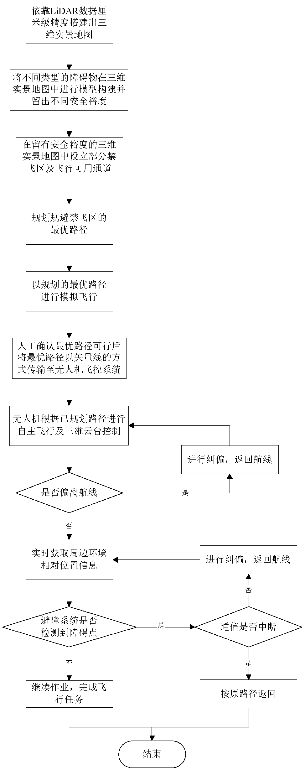
[0024] This embodiment discloses a method for autonomous flight of a UAV based on LiDAR data to construct a three-dimensional real scene,

[0025] The autonomous flying method of the unmanned aerial vehicle comprises the following steps:

[0026] Construct an autonomous flight no-fly zone. The no-fly zone Ω is based on the 3D real scene constructed based on LiDAR point cloud data. Algorithms are used to divide flyable blocks and no-fly blocks to prevent unmanned areas caused by unreasonable path planning. a plane crash occurs;

[0027] Route autonomous planning and flight, the route autonomous planning flight is the process of autonomously planning the optimal flight path of UAV power inspection and realizing autonomous flight based on differential GPS combined with LiDAR data according to the prescribed principles;


PUM


Abstract

The invention discloses an unmanned aerial vehicle autonomous flight method for constructing a three-dimensional real scene based on LiDAR data. The unmanned aerial vehicle autonomous flight method comprises the steps of constructing an autonomous flight no-fly zone, carrying out route autonomous planning and flying, and autonomously performing route correction and obstacle avoidance, wherein theno-fly zone is in the three-dimensional real scene constructed on the basis of LiDAR point cloud data, and a flyable block and a no-fly block are divided by using an algorithm; the route autonomous planning flight is the process of combining differential GPS with the LiDAR data and autonomously planning the optical flight route of unmanned aerial vehicle electric power inspection according to a specified principle and realizing autonomous flying; and the route correction and obstacle avoidance regards a planned flight path and airborne radar data as judgment standards, conducts flight path correction on the situation that flight deviates from the flight path due to internal and external factors, and can realize autonomous original-path return can be achieved when necessary. The unmanned aerial vehicle autonomous flight method solves problems of large line patrol potential safety hazards, low line patrol efficiency and redundant personnel allocation of an existing unmanned aerial vehicle.

Description

technical field [0001] The invention relates to the technical field of autonomous power inspection of unmanned aerial vehicle, in particular to an autonomous flying method of unmanned aerial vehicle based on LiDAR data to construct a three-dimensional real scene. Background technique [0002] The transmission lines in China are scattered, wide in area, complex in terrain and harsh in natural environment. Power lines and tower accessories have been exposed to the wild for a long time, and they must be repaired or replaced in time due to continuous mechanical tension, lightning flashover, material aging, and human influence. Insulators are also damaged by lightning strikes, tree growth causes power line discharge, and towers are stolen and other unexpected events must also be dealt with in a timely manner. The traditional manual inspection method not only has a large workload but also has difficult conditions, especially for inspections of mountainous areas and transmission l...

Claims


Application Information

Patent Timeline
Patent Type & Authority Applications(China)
IPC IPC(8): G05D1/10G06T17/00
CPCG05D1/101G06T17/00
Inventor 不公告发明人
Owner 杨扬
Why Eureka
Try Eureka