A Method for Recognition of Road Intersections in Trajectory Data Based on Statistical Clustering

A technology of trajectory data and recognition methods, applied in character and pattern recognition, computing, measuring devices, etc.

Active Publication Date: 2020-11-27
湖南博通信息股份有限公司 +1
View PDF6 Cites 0 Cited by
  • Summary
  • Abstract
  • Description
  • Claims
  • Application Information

AI Technical Summary

Problems solved by technology

The technical problems solved by the present invention mainly include: ① automatic detection of turning track points at road intersections in track data; ② adaptive clustering of track points to calculate the center position and spatial range of road intersections; Intersection location detection efficiency and automation level to solve the problem of rapid location of road intersections in trajectory data

Method used


Image

  • A Method for Recognition of Road Intersections in Trajectory Data Based on Statistical Clustering
  • A Method for Recognition of Road Intersections in Trajectory Data Based on Statistical Clustering
  • A Method for Recognition of Road Intersections in Trajectory Data Based on Statistical Clustering

Examples


Embodiment 1

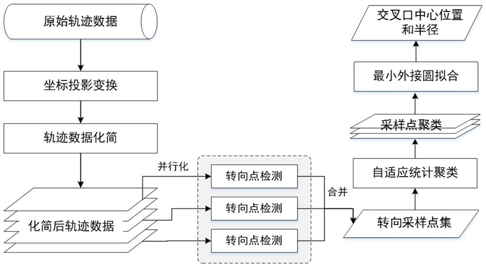
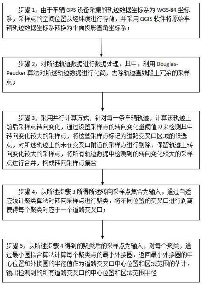
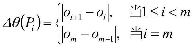
[0041] This embodiment provides a figure 1 The shown method for identifying the location of road intersections in trajectory data based on statistical clustering, the specific implementation steps are as follows figure 2 shown, including the following steps:

[0042] Step 1, since the trajectory data collected by the vehicle GPS device is in the WGS-84 coordinate system, and the coordinates of the trajectory data are represented by latitude and longitude, coordinate conversion is required to directly calculate the spatial distance between two trajectory points. In order to facilitate the calculation of spatial distance, firstly, QGIS software is used to transform the coordinate system of the original vehicle trajectory data into a planar projected Cartesian coordinate system. Among them, when setting the projection parameters of QGIS coordinate transformation, the plane projection Cartesian coordinate system chooses the Gauss-Krüger projection of the 6-degree zone as the pro...


PUM


Abstract

The invention provides a method for identifying the location of road intersections in trajectory data based on statistical clustering, including trajectory data coordinate projection conversion, and trajectory data simplification processing; for the simplified trajectory data, a multi-core parallel computing method is adopted, and the direction is turned according to the sampling point The sampling points in the change recognition road intersection area constitute a set of steering sampling points; the set of steering sampling points is used as input, and the adaptive statistical clustering algorithm is used to automatically divide the clusters, and the road intersections at different locations are separated; finally, For each turning sampling point cluster, the center position and radius of the minimum circumscribed circle covering the cluster are calculated by the minimum circumscribed circle fitting algorithm, and the center position and area range of the road intersection are represented by the center and radius of the minimum circumscribed circle .

Description

technical field [0001] The invention relates to the intersecting fields of computer vision and track data processing, in particular to a method for identifying the position of road intersections in track data based on statistical clustering. Background technique [0002] The road network map is an important basic geographic information data, and it is also an important data source that applications such as traffic travel and route planning rely on. With the rapid development of urban construction, the urban road network is also constantly updated and changed. At present, commonly used map data update technologies and methods (such as field survey and mapping, remote sensing data mapping, etc.) are faced with the problems of long data update cycle and high cost when applied to road network data update, so how to obtain updated and timely road network map data It is still a difficult problem to be solved at present. With the widespread application of the Global Positioning S...

Claims


Application Information

Patent Timeline
Patent Type & Authority Patents(China)
IPC IPC(8): G06K9/62G01S19/42
CPCG01S19/42G06F18/23
Inventor 邓敏张建国郑旭东唐建波刘慧敏陈雪莹黄金彩张华剑姚劲张幼英芦春霞石岩刘宝举
Owner 湖南博通信息股份有限公司
Why Eureka
Try Eureka