Laser point cloud data processing method, device and system

A technology of laser point cloud data and processing method, which is applied in the field of three-dimensional measurement, can solve problems such as poor smoothness of data position, low measurement accuracy, deformation of laser point cloud data, etc., and achieve the effect of reducing processing error and improving measurement accuracy

Active Publication Date: 2020-04-14
WUHAN HANNING TECH +1
View PDF7 Cites 13 Cited by
  • Summary
  • Abstract
  • Description
  • Claims
  • Application Information

AI Technical Summary

Problems solved by technology

[0002] In related technologies, since the position and orientation system (POS) relies on the positioning information of GNSS (GNSS Global Navigation Satellite System) and the real-time attitude angle of inertial navigation devices for integrated navigation calculation, in tunnels, etc. In a measurement environment without GNSS, GPS (Global Positioning System, Global Positioning System) is used to participate in the solution. The data position of POS (position and orientation system, positioning and attitude determination system) is poor, and its attitude angle is also affected by IMU (Inertial measurement unit, inertial measurement unit). Unit, also known as inertial navigation device) accumulates error effects over time, resulting in serious deformation of laser point cloud data and low measurement accuracy

Method used


Image

  • Laser point cloud data processing method, device and system
  • Laser point cloud data processing method, device and system
  • Laser point cloud data processing method, device and system

Examples


Embodiment Construction

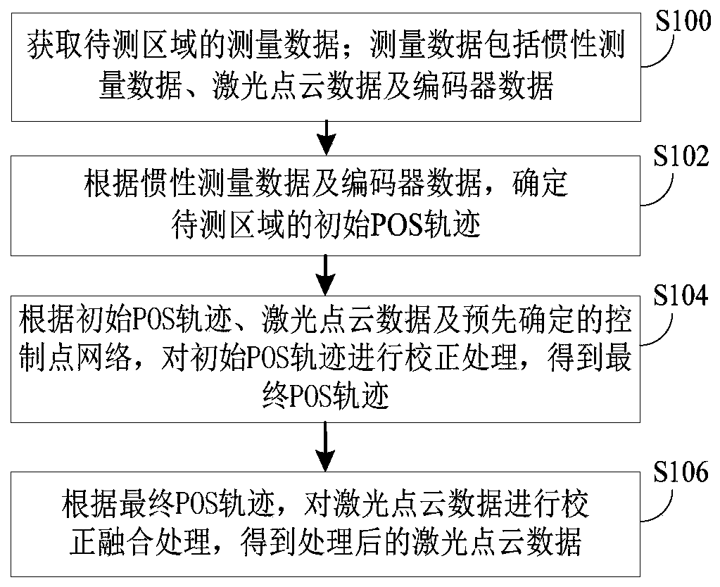
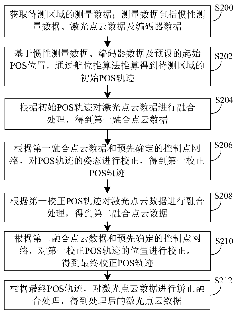
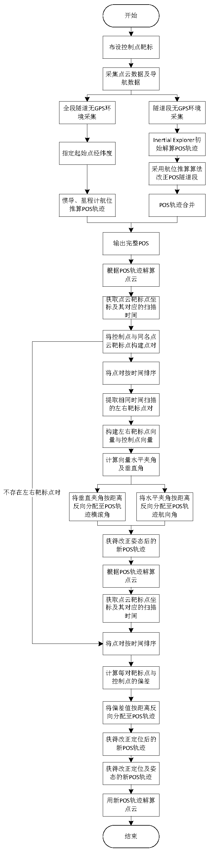
[0028] The technical solutions of the present invention will be clearly and completely described below in conjunction with the embodiments. Obviously, the described embodiments are part of the embodiments of the present invention, but not all of them. Based on the embodiments of the present invention, all other embodiments obtained by persons of ordinary skill in the art without making creative efforts belong to the protection scope of the present invention.

[0029] The mobile measurement technology integrating 3D laser scanning, panoramic camera and inertial navigation positioning and attitude sensor is a new surveying and mapping technology developed in the past two decades. Compared with traditional surveying and mapping methods, mobile measurement technology has unparalleled advantages in terms of data collection efficiency and data richness; the measurement accuracy of this technology has also improved with GNSS, inertial navigation devices (belonging to inertial navigati...


PUM


Abstract

The invention provides a laser point cloud data processing method, device and system, and the method comprises the steps: determining an initial POS track of a to-be-measured region according to inertia measurement data and encoder data after the measurement data of the to-be-measured region is obtained; correcting the attitude and position of the initial POS track through the initial POS track, laser point cloud data and a predetermined control point network to obtain a final corrected POS track; and according to the final POS track, carrying out correction fusion on the laser point cloud data to obtain processed laser point cloud data. According to the invention, the POS track is corrected in a tunnel and other GNSS-free measurement environments, the laser point cloud data processing error is reduced, and the measurement precision of the to-be-measured region is improved.

Description

technical field [0001] The invention relates to the technical field of three-dimensional measurement, in particular to a laser point cloud data processing method, device and system. Background technique [0002] In related technologies, since the position and orientation system (POS) relies on the positioning information of GNSS (GNSS Global Navigation Satellite System) and the real-time attitude angle of inertial navigation devices for integrated navigation calculation, in tunnels, etc. In a measurement environment without GNSS, GPS (Global Positioning System, Global Positioning System) is used to participate in the solution. The data position of POS (position and orientation system, positioning and attitude determination system) is poor, and its attitude angle is also affected by IMU (Inertial measurement unit, inertial measurement unit). Unit, also known as inertial navigation device) accumulates error effects over time, resulting in serious deformation of laser point clo...

Claims


Application Information

Patent Timeline
Patent Type & Authority Applications(China)
IPC IPC(8): G01S17/88G01S7/497G01C21/16
CPCG01S17/88G01S7/497G01C21/165
Inventor 李清泉毛庆洲熊勇钢李夏亮朱旭波李杨余建伟来德辉
Owner WUHAN HANNING TECH
Why Eureka
Try Eureka