Seabed three-dimensional terrain investigation and surveying underwater unmanned vehicle

An unmanned vehicle, three-dimensional terrain technology, applied in the directions of underwater ships, underwater operation equipment, instruments, etc., can solve the problems of large measurement results error, low work efficiency, high energy consumption, reduce vibration and noise, Increase the efficiency of transmission and increase the effect of waterproof life

Pending Publication Date: 2020-04-21
HARBIN ENG UNIV
View PDF12 Cites 4 Cited by
  • Summary
  • Abstract
  • Description
  • Claims
  • Application Information

AI Technical Summary

Problems solved by technology

1. Ship measurement: It is measured simultaneously by the echo sounder and side-scan sonar installed under the bottom of the ship. According to the echo map combined with the positioning of the navigation equipment on the ship, data analysis is performed to calculate the topography and landform of the sea area. This measurement method is for The complexity of the terrain and the depth of measurement have great limitations, which can no longer meet the existing requirements
2. Satellite remote sensing measurement: on-orbit satellites are determined by the color difference of seawater. This measurement method has high requirements for the color of seawater, and the measurement results of physical properties in different sea areas have a greater impact. Combined with the later algorithm, it can only be measured simply. The general terrain and landform, the measurement results have great errors, and cannot accurately reflect the subtle topography and landform features
At present, there are aircrafts, but the single dive time is too long, the volume is large, the energy consumption is high, the work efficiency is low, the performance of hovering and turning is low, and the discrimination error of complex targets is relatively large, which can no longer meet the actual production needs of our country.

Method used


Image

  • Seabed three-dimensional terrain investigation and surveying underwater unmanned vehicle
  • Seabed three-dimensional terrain investigation and surveying underwater unmanned vehicle
  • Seabed three-dimensional terrain investigation and surveying underwater unmanned vehicle

Examples


Embodiment Construction

[0033] The following examples describe the present invention in more detail.

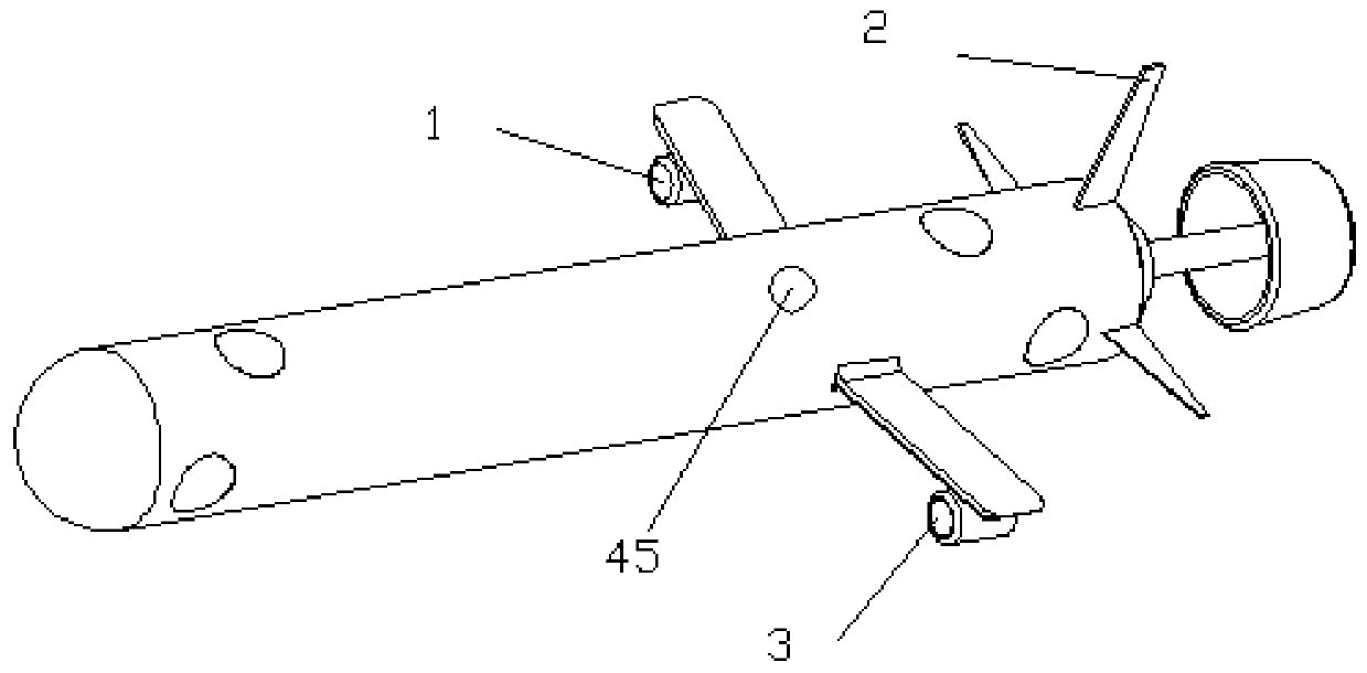
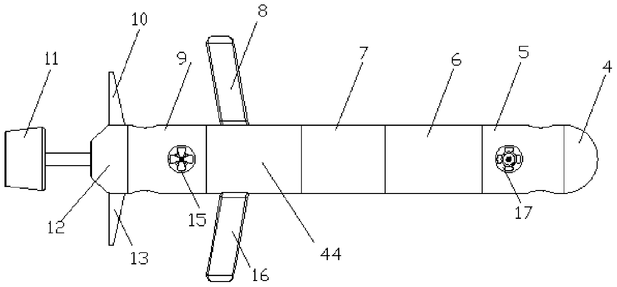
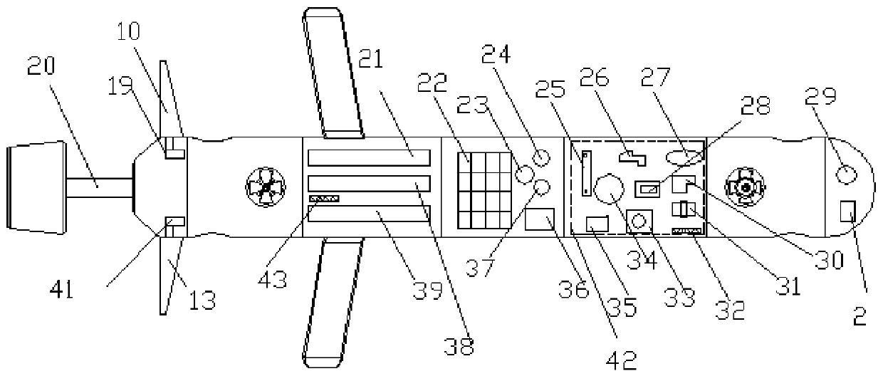
[0034]The first embodiment of the underwater vehicle used for the survey and mapping of the three-dimensional topographic structure of the seabed according to the present invention includes a plurality of pressure-resistant cabins, and the adjacent pressure-resistant cabins are connected by a sealed connection mechanism; the pressure-resistant cabins Including the first warehouse 4, the second warehouse 5, the third warehouse 6, the fourth warehouse 7, the fifth warehouse 44, the sixth warehouse 9 and the tail warehouse 12 which are connected end to end in sequence; the first warehouse 4 is equipped with multi-frequency forward-looking sonar 29, Sonar transducer; No. 2 warehouse 5 is equipped with first horizontal propeller 18 and first vertical propeller 17; No. 3 warehouse 6 is equipped with integrated main board 42, and central processing unit 28 and strapdown inertial navigation are integrated on...


PUM


Abstract

The invention provides a submarine three-dimensional terrain investigation and surveying and mapping unmanned underwater vehicle which comprises a plurality of pressure-resistant bins, and every two adjacent pressure-resistant bins are connected through a sealing connecting mechanism; each pressure-resistant bin comprises a tail bin, and the rear portion of the tail bin is connected with a main propeller through a connecting mechanism; the main propeller comprises a main shaft, an aluminum base body, inner rotor magnetic stripes, outer rotor magnetic stripes, a protective cover and a propellerhub, each of the inner rotor magnetic stripes and the outer rotor magnetic stripes comprises a plurality of magnetic stripe rings, inner rotor space rings are arranged among the magnetic stripe ringsof the inner rotor magnetic stripes, and outer rotor space rings are arranged among the magnetic stripe rings of the outer rotor magnetic stripes; the main shaft is located in the middle of the aluminum base body, the inner rotor magnetic strips and the inner rotor space rings are fixed to the outer side face of the aluminum base body, the outer rotor magnetic strips and the outer rotor space rings are fixed to the inner side face of the propeller hub, and the protective cover is located between the inner rotor magnetic strips and the outer rotor magnetic strips. The main propeller of the underwater vehicle is high in transmission efficiency, high in working efficiency, high in energy utilization rate and high in accuracy.

Description

technical field [0001] The invention relates to an underwater AUV, in particular to an underwater unmanned vehicle used for surveying and mapping the three-dimensional topographic structure of the seabed. Background technique [0002] The ocean occupies 70% of the earth's surface. The ocean is strange and mysterious to human beings. The seabed is as undulating as the land, with mountains, deep valleys, and vast plains and basins. In recent years, with the development and utilization of marine resources, the measurement of seabed topography is particularly important. The measurement of seabed topography and landform can be used for precise navigation of ships, development of marine resources, marine demarcation, sea surface and seabed. Provide various data for engineering design and construction, as well as for studying the dynamics of the seafloor crust and tidal changes. There are mainly three methods for measuring ocean topography and landform. 1. Ship measurement: It is...

Claims


Application Information

Patent Timeline
Patent Type & Authority Applications(China)
IPC IPC(8): B63G8/00G01S15/89G01S15/93
CPCB63G8/001B63G2008/002G01S15/89G01S15/93Y02A90/30
Inventor 袁利毫昝英飞祝海涛贾辉丁天宝
Owner HARBIN ENG UNIV
Why Eureka
Try Eureka