Polar region inertial navigation error acquiring method under earth ellipsoid model

An ellipsoid model and error equation technology, applied in the field of inertial navigation, can solve problems such as affecting the accuracy of polar navigation, the error of the mathematical model principle, and the inability to accurately describe the error propagation process, so as to reduce the impact, improve the accuracy, and improve the accuracy of the model. Effect

Active Publication Date: 2020-04-24
NORTHWESTERN POLYTECHNICAL UNIV
View PDF8 Cites 4 Cited by
  • Summary
  • Abstract
  • Description
  • Claims
  • Application Information

AI Technical Summary

Problems solved by technology

[0004] However, the existing error model for grid inertial calculation in the polar region is derived from the spherical model of the earth, and the error equation cannot accurately describe the error propagation process, which introduces a principle error into the mathematical model and affects integrated navigation and transfer alignment in the polar region the accuracy of

Method used


Image

  • Polar region inertial navigation error acquiring method under earth ellipsoid model
  • Polar region inertial navigation error acquiring method under earth ellipsoid model
  • Polar region inertial navigation error acquiring method under earth ellipsoid model

Examples


Embodiment Construction

[0054] Now in conjunction with embodiment, accompanying drawing, the present invention will be further described:

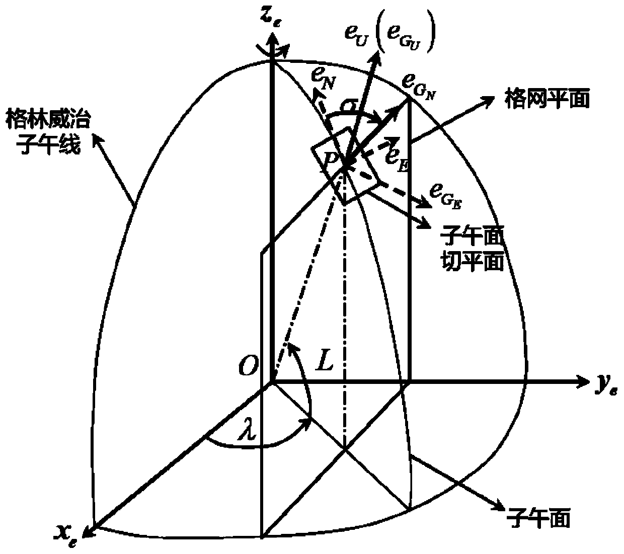
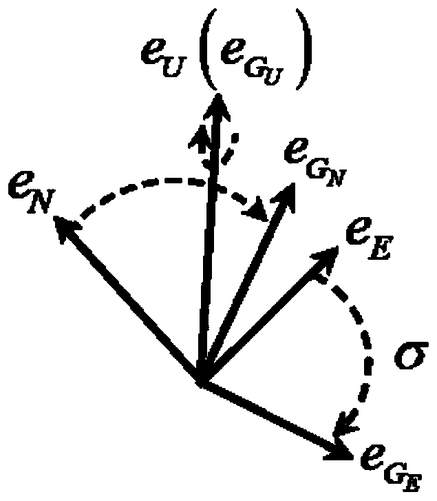
[0055] 1. The relationship between the position error of the Cartesian coordinate system and the longitude and latitude error of the geographic coordinate system

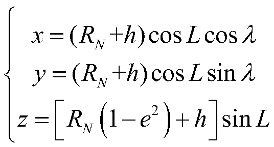
[0056] The relationship between the position of the Cartesian coordinate system and the longitude, latitude and height of the geographic coordinate system is the following formula, where: (x, y, z) represents the position of the Cartesian coordinate system, and (L, λ, h) represents the longitude and latitude of the geographic coordinate system and height, e is the flatness of the earth.

[0057]

[0058] In a short period of time, it is considered that the main curvature radius R of the earth's Maoyou circle N and the earth's meridian principal radius of curvature R M The change is small and is constant.

[0059] The first-order full increment of Cartesian error (δx, δy, δz):

[0060]

[0061] ...


PUM


Abstract

The invention relates to a polar region inertial navigation error acquiring method under an earth ellipsoid model. A calculation error source under the earth ellipsoid model is added into an attitudeerror equation; the grid speed is expressed as a grid speed true value and a grid speed error by a speed error equation, and various error sources are added; and a position error equation adopts a rectangular coordinate system to solve the position, and a grid calculation value containing the grid position true value and the grid position error is added into an error source. Compared with the prior art, the method has the advantages that the error model for polar region inertial navigation calculation under the earth ellipsoid model is established, the influence of the earth sphere model on the precision of the error propagation process is reduced, the accuracy of the model is improved, and therefore the precision of polar region integrated navigation and transfer alignment is improved.

Description

technical field [0001] The invention belongs to the field of inertial navigation and relates to a method for obtaining inertial navigation errors in polar regions under an earth ellipsoid model. Background technique [0002] The core of the inertial navigation system algorithm is the mechanical arrangement, and there are two main types: the north-pointing azimuth mechanical arrangement and the wandering azimuth mechanical arrangement. The concept of north azimuth inertial navigation mechanics arrangement is simple and its physical meaning is clear, but there are problems such as azimuth calculation overflow and error amplification in the point north arrangement in high latitude areas. As the latitude increases, the calculation accuracy of the azimuth gyro command velocity item gradually decreases until the calculation overflows, and the calculation error of the horizontal velocity is seriously amplified, and even overflows. Therefore, the north azimuth system cannot work no...

Claims


Application Information

Patent Timeline
Patent Type & Authority Applications(China)
IPC IPC(8): G01C25/00G06F17/12G06F17/13
CPCG01C25/005G06F17/12G06F17/13
Inventor 张通常晓飞符文星
Owner NORTHWESTERN POLYTECHNICAL UNIV
Why Eureka
Try Eureka