Construction site virtual construction restoration method based on BIM + GIS

A technology for construction site and terrain data, which is applied in the field of virtual construction and restoration of construction sites based on BIM+GIS, can solve problems such as unfavorable monitoring, inability to reflect the effects intuitively, easy occurrence of abandoned land and dead ends, etc., and achieve the effect of small errors.

Active Publication Date: 2020-05-26
福建建工集团有限责任公司 +1
View PDF5 Cites 13 Cited by
  • Summary
  • Abstract
  • Description
  • Claims
  • Application Information

AI Technical Summary

Problems solved by technology

[0006] Existing construction site layout technology only relies on construction experience and specifications for planning and design on CAD drawings. The effect cannot be reflected intuitively, and it is prone to waste land and dead ends, as well as the secondary handling caused by different construction stages (periods) and the demolition and reconstruction of processing plants and warehouse yards, resulting in waste of resources; The backup materials of the objects that need to be restored after protection or project completion are inaccurate, which makes the protection or restoration quite different from the original state, which is not conducive to monitoring

Method used


Image

  • Construction site virtual construction restoration method based on BIM + GIS

Examples


specific Embodiment approach

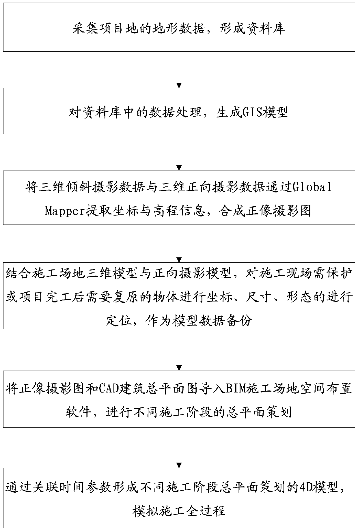
[0029] A specific implementation is as follows:

[0030] 1. Determine the surrounding environment of the project site and the scope of aerial photography modeling. According to the shape, scope and surrounding buildings, the flight sorties are divided reasonably, and the parameters such as flight height, flight speed, shooting interval, heading distance, side distance and other parameters are set reasonably. Choosing the best aerial photography solution will help to improve operation efficiency, reduce "jelly effect" and "moiré pattern", and improve model accuracy.

[0031] (Explanation of terms: At the beginning of exposure, the image sensor scans and exposes line by line until all pixels are exposed. Of course, all actions are completed in a very short time, and generally will not affect the shooting. But If the object to be photographed moves or vibrates at a high speed relative to the camera. Shooting in rolling shutter mode, the progressive scan speed is not enough, and ...


PUM


Abstract

The invention provides a construction site virtual construction restoration method based on BIM + GIS, and the method comprises the steps of collecting the topographic data of a project site, and forming a database; processing the data in the database to generate a GIS model; extracting coordinates and elevation information of the three-dimensional oblique photography data and the three-dimensional forward photography data through a Global Mapper, so a forward photography map is synthesized; combining the construction site three-dimensional model and the forward photography model, and positioning coordinates, sizes and forms of objects needing to be protected on the construction site or needing to be restored after a project is completed to serve as model data backup; positioning coordinates, sizes and forms of objects needing to be protected on a construction site or needing to be restored after a project is completed, and providing data help for follow-up reinforcement, protection and restoration scheme making and work. By utilizing the characteristics of high precision, visualization, high efficiency and the like of the BIM + GIS technology, a construction total plane arrangement diagram is deeply designed, and a project construction site is assisted to realize green construction.

Description

technical field [0001] The invention relates to a virtual construction restoration method of a construction site based on BIM+GIS. Background technique [0002] Whether the layout of the construction site is scientific and reasonable directly affects the production efficiency. In the early stage of the project, it is necessary to plan and implement the space and layout of the construction site. It is often necessary to simulate the layout in combination with the topography and topography of the site, surrounding existing buildings, proposed buildings, construction process period, and the location and elevation of temporary facilities. Cloth, plan and then move. [0003] At present, BIM (Building Information Modeling) is not only a new tool for architectural design, but also a new tool for building construction, operation and maintenance. The core of it is the model as the carrier, using digital technology to display all kinds of physical data and actual information of arch...

Claims


Application Information

Patent Timeline
Patent Type & Authority Applications(China)
IPC IPC(8): G06F30/13G06F30/20G06T17/05
CPCG06T17/05Y02T10/40
Inventor 林章凯陈至程彬王宗成曾庆友郑景昌郑立郑侃翁世平倪杨黄伟兴
Owner 福建建工集团有限责任公司
Why Eureka
Try Eureka