Calculation method of solar illumination compensation value

A light compensation and solar technology, applied in the field of image processing, can solve the problems of remote sensing image processing and application difficulties

Active Publication Date: 2021-04-09
INST OF ELECTRONICS CHINESE ACAD OF SCI
View PDF2 Cites 0 Cited by
  • Summary
  • Abstract
  • Description
  • Claims
  • Application Information

AI Technical Summary

Problems solved by technology

In addition, because the earth itself is circular, even at the same time, the light intensity at different longitudes and latitudes is different, which leads to differences in the brightness of images taken by geostationary optical remote sensing satellites on different dates, different times, and different locations. There is a big difference, which causes great difficulties for the subsequent processing and application of remote sensing images

Method used


Image

  • Calculation method of solar illumination compensation value
  • Calculation method of solar illumination compensation value
  • Calculation method of solar illumination compensation value

Examples


Embodiment Construction

[0024] In order to make the object, technical solution and advantages of the present invention clearer, the present invention will be described in further detail below in conjunction with specific embodiments and with reference to the accompanying drawings.

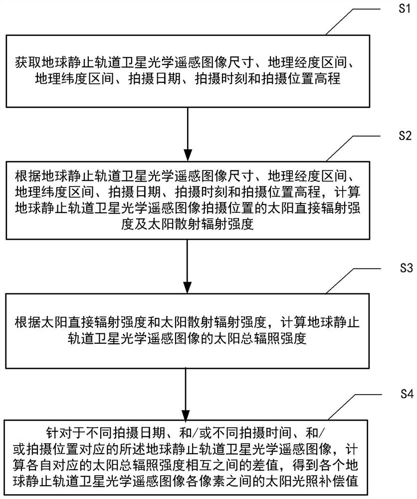
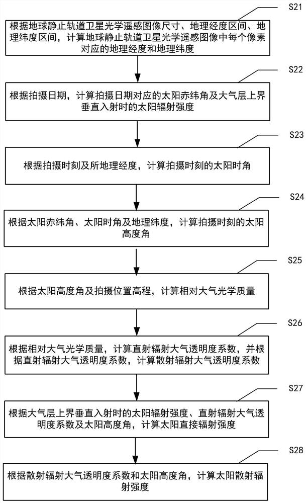
[0025] The embodiment of the present invention proposes a solar illumination compensation value method for geostationary satellite optical remote sensing images. Position elevation, calculate the solar declination angle, solar hour angle, solar altitude angle, solar radiation intensity, atmospheric optical quality, direct radiation atmospheric transparency coefficient, direct radiation intensity, diffuse radiation atmospheric transparency coefficient, diffuse radiation intensity, solar total The irradiance intensity is used to realize the calculation of the solar illumination compensation value for the optical remote sensing images of geostationary orbit satellites taken at different dates, different times, and different l...


PUM


Abstract

A calculation method for solar illumination compensation value, comprising: obtaining the size, geographic longitude interval, geographic latitude interval, shooting date, shooting time, and shooting location elevation of an optical remote sensing image of a geostationary satellite; according to the remote sensing image size, geographic longitude interval, geographic Latitude interval, shooting date, shooting time and shooting position elevation, calculate the direct radiation intensity and scattered radiation intensity of the shooting position of the optical remote sensing image of the geostationary satellite; according to the direct radiation intensity and scattered radiation intensity, calculate the Total solar irradiance; for the optical remote sensing images of geostationary satellites corresponding to different shooting dates, different shooting times, and shooting positions, calculate the difference between the corresponding total solar irradiance and obtain the optical data of each geostationary satellite. The solar illumination compensation value between each pixel of the remote sensing image. The method has low computational complexity, fast running speed and easy engineering implementation.

Description

technical field [0001] The invention relates to the field of image processing, in particular to a method for calculating solar illumination compensation values. Background technique [0002] The orbital period of the geostationary optical remote sensing satellite is the same as the earth's rotation period, and it remains relatively stationary with the earth. It has a large imaging width and can continuously observe a large area of ​​designated interest area. Good timeliness and other advantages. However, the intensity of light at the same location on Earth varies from day to day due to the Earth's rotation and orbit around the sun. In addition, because the earth itself is circular, even at the same time, the light intensity at different longitudes and latitudes is different, which leads to differences in the brightness of images taken by geostationary optical remote sensing satellites on different dates, different times, and different locations. There is a big difference, ...

Claims


Application Information

Patent Timeline
Patent Type & Authority Patents(China)
IPC IPC(8): G01N21/17G06F30/20
CPCG01N21/17G01N2021/1765G01N2021/1793G01N2021/1795
Inventor 吕鹏胡玉新雷斌李倩倩侯仰拴
Owner INST OF ELECTRONICS CHINESE ACAD OF SCI
Why Eureka
Try Eureka