Remote sensing image building extraction method and system based on U-Net network and electronic equipment

A technology of remote sensing images and extraction methods, which is applied to biological neural network models, instruments, character and pattern recognition, etc. It can solve problems such as poor versatility and general extraction effects, achieve enhanced capabilities, reduce training time, and improve image resolution Effect

Pending Publication Date: 2020-07-28
CHINA UNIV OF GEOSCIENCES (WUHAN)
View PDF8 Cites 14 Cited by
  • Summary
  • Abstract
  • Description
  • Claims
  • Application Information

AI Technical Summary

Problems solved by technology

[0004] The current technical method based on remote sensing image building extraction can only extract relatively regular and distinctive buildings, and its versatility is poor. When the buildings are relatively dense, the extraction effect is general. Therefore, how to quickly and accurately extract various complex buildings is a key issue in remote sensing information processing. key steps

Method used


Image

  • Remote sensing image building extraction method and system based on U-Net network and electronic equipment
  • Remote sensing image building extraction method and system based on U-Net network and electronic equipment
  • Remote sensing image building extraction method and system based on U-Net network and electronic equipment

Examples


Embodiment 1

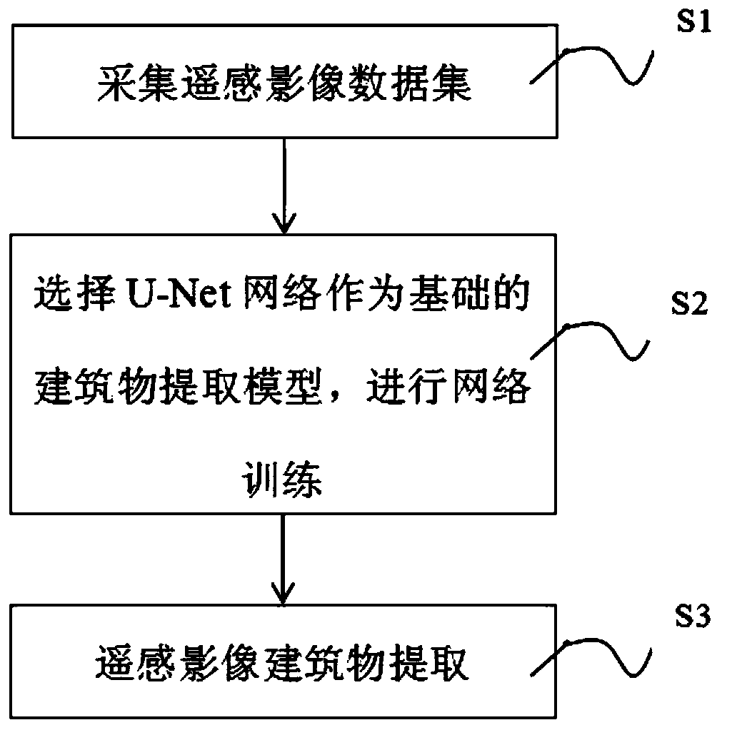
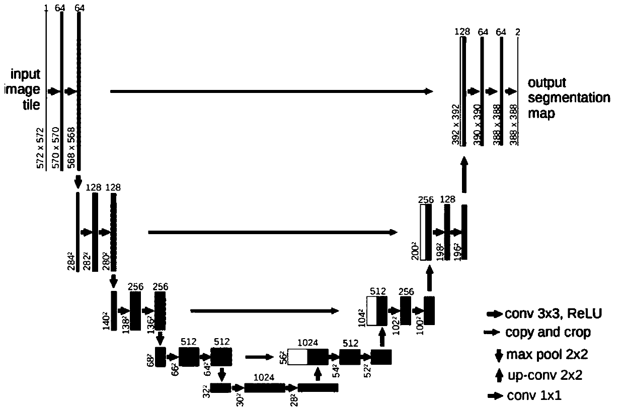
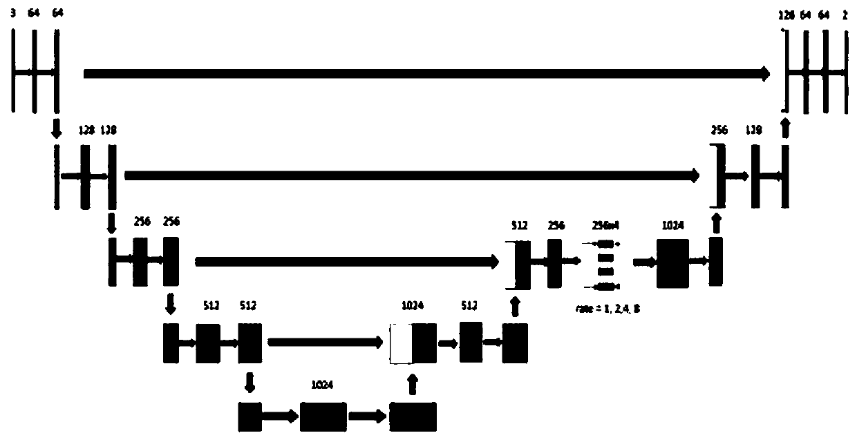
[0034] Please refer to figure 1 , which is a step diagram of a method for extracting buildings from remote sensing images based on the U-Net network, including the following steps:

[0035] S1. Collect a data set including several remote sensing images; segment and cut each remote sensing image to obtain a surface vector file containing classified objects, and draw the building label in the surface vector file, and label the building as described The vector data of the surface vector sample is converted into raster data, and the rasterized building sample is obtained; specifically during implementation:

[0036] The data sets of the several remote sensing images include: downloading a dedicated ultra-high resolution remote sensing image semantic segmentation data set on ISPRS, and selecting the Potsdam data set (Potsdam data set) as subsequent input to the U-Net network for network training data Among them, the data set includes a total of 38 orthophoto images; the spatial re...

Embodiment 2

[0064] In order to improve the extraction accuracy of the image, based on embodiment 1, in step S3, the opening and closing operations are used sequentially when extracting the building image, the edges of the image are smoothed, and the broken points in the image are removed, so as to improve the extraction of the image Accuracy; wherein, the mathematical form of opening and closing operations is defined as shown in the following formula (1) and formula (2):

[0065]

[0066]

[0067] Parameter A original binary image, parameter B is a structural element (the structural element can be a square or a prototype); in the formula (1) Indicates open operation; Indicates the expansion parameter A of the parameter B; "AΘB" indicates the corrosion parameter A of the parameter B; "·" in the formula (2) indicates the closing operation.

[0068] The detailed process of the above parameter B expanding parameter A is as follows:

[0069] The parameter B has a definable anchor poi...


PUM


Abstract

The invention discloses a remote sensing image building extraction method and system based on a U-Net network, and electronic equipment. A multi-scale module is added to a decoding layer of a U-Net network, and the hole convolution network is introduced, the receptive field can be expanded under the condition that the resolution is not lost through hole convolution, so that the semantic information mining capacity of the network can be improved while detail information is reserved, and meanwhile, the multi-scale feature obtaining capacity of the network is enhanced through the multi-scale module; according to the invention, the convolution mode of the convolution layer is set as filling; that is, after convolution, the size of the feature map is completely unchanged; the original feature map is actually shrunk by 2; in this way, each time the feature map passes through a convolution layer , the size of the feature map is reduced by two times; by the adoption of the convolution model, the size of the feature map output through the four coding layers and the last coding layer is shrunk to be one sixteenth of the size of the input picture after the feature map passes through 4 encoding layers, the image resolution is recovered through deconvolution operation, the size of the feature map begins to be enlarged at the moment, and the training time is effectively shortened.

Description

technical field [0001] The invention belongs to the field of image extraction, and in particular relates to a U-Net network-based remote sensing image building extraction method, system and electronic equipment. Background technique [0002] Buildings are the most likely to be added and changed in the geographic database, and also the part that most needs to be updated. Due to the importance of buildings for urban construction, GIS system updates, digital cities, and military reconnaissance, rapid extraction of building information technology and building change detection have important applications in urban development planning, electronic informatization, and national defense. . The extraction of artificial building information in remote sensing images is a complicated process, which not only requires automatic recognition by computers, but also requires human assistance, resulting in low efficiency of building extraction. [0003] In recent years, with the great improve...

Claims


Application Information

Patent Timeline
Patent Type & Authority Applications(China)
IPC IPC(8): G06K9/00G06K9/34G06N3/04
CPCG06V20/176G06V10/267G06N3/045
Inventor 陈珺王干北罗林波龚文平宋俊磊魏龙生
Owner CHINA UNIV OF GEOSCIENCES (WUHAN)
Why Eureka
Try Eureka