Shipborne GNSS-R-based effective wave height inversion method and system

An effective wave height and inversion technology, which is used in radio wave measurement systems, radio wave reflection/re-radiation, satellite radio beacon positioning systems, etc. The problem of high cost, to achieve the effect of high signal processing capability, abundant signal sources and low maintenance cost

Pending Publication Date: 2020-08-25
DALIAN MARITIME UNIVERSITY
View PDF5 Cites 8 Cited by
  • Summary
  • Abstract
  • Description
  • Claims
  • Application Information

AI Technical Summary

Problems solved by technology

Sea surface significant wave height is of great significance to the safety and sustainable development of marine environment monitoring and ocean shipping. Traditionally, the main way to monitor sea surface significant wave height is through marine observation stations and nautical wave observation instruments. The...

Method used


Image

  • Shipborne GNSS-R-based effective wave height inversion method and system
  • Shipborne GNSS-R-based effective wave height inversion method and system
  • Shipborne GNSS-R-based effective wave height inversion method and system

Examples


Embodiment Construction

[0030] In order to make the technical solutions and advantages of the present invention more clear, the technical solutions in the embodiments of the present invention are clearly and completely described below in conjunction with the drawings in the embodiments of the present invention:

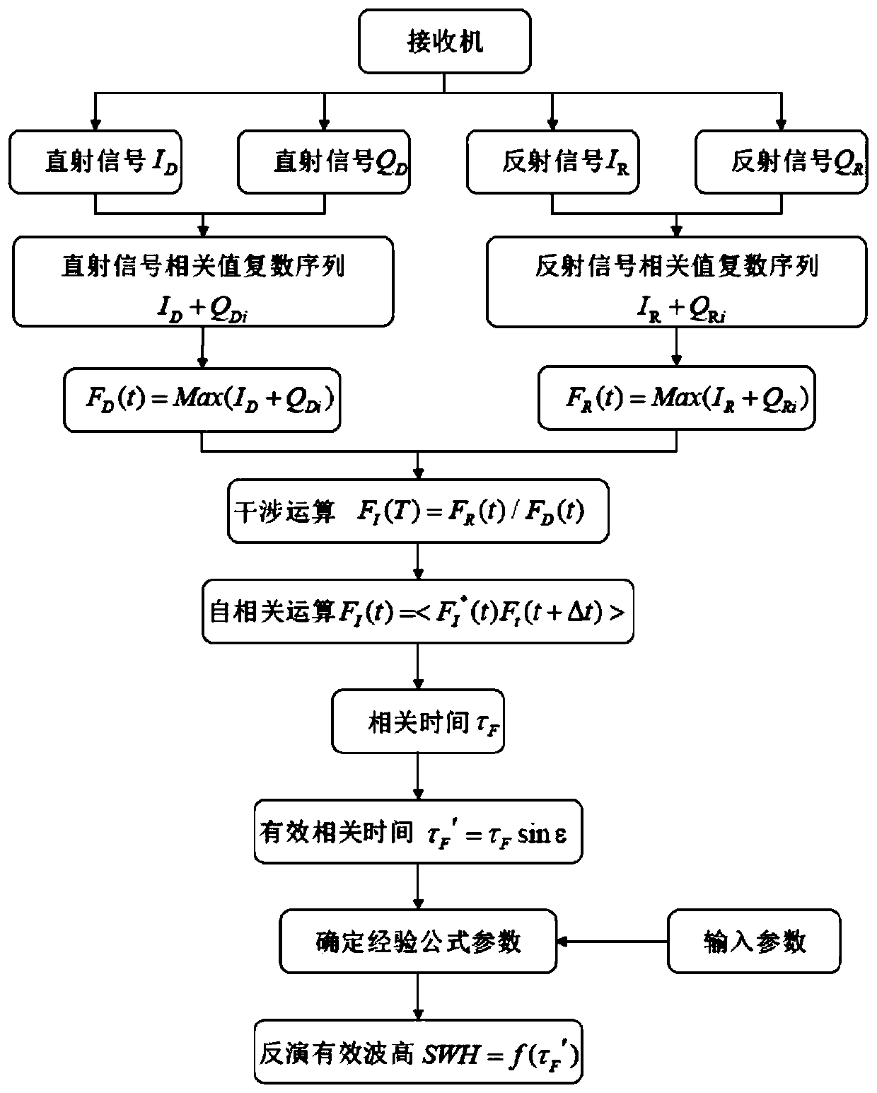
[0031] Such as figure 1 A method of effective wave height retrieval based on shipborne GNSS-R is shown, which specifically includes the following steps:

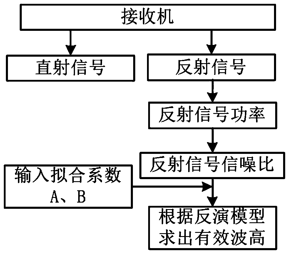
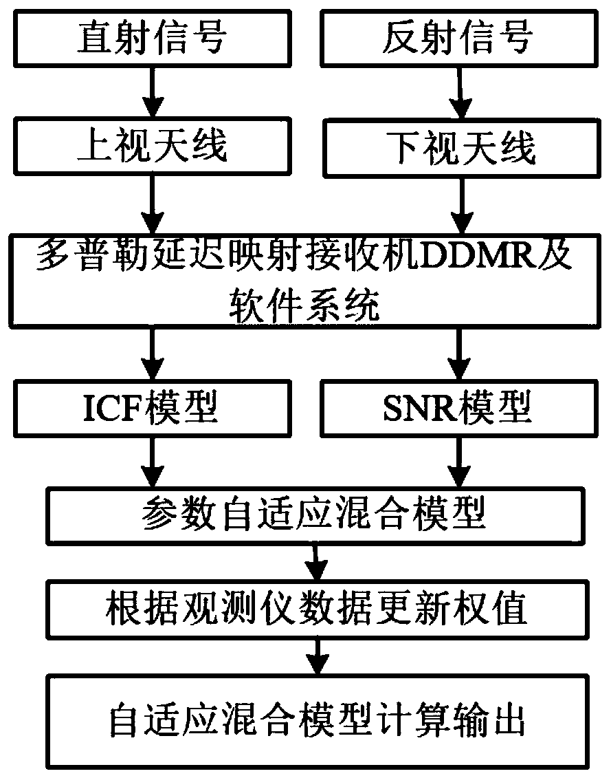
[0032] The shipborne GNSS-R hardware receiver obtains the direct signal of the navigation satellite and the reflected signal after encountering the reflection interface through the upward-looking antenna and the downward-looking antenna, and transmits the original data to the Doppler through different serial ports and transmission baud rates. The delay-mapping receiver DDMR performs subsequent processing.

[0033] Further, in the Doppler delay mapping receiver DDMR, the obtained direct signal and reflected signal are converted into a digi...


PUM


Abstract

The invention discloses a shipborne GNSS-R-based significant wave height inversion method and system. The method comprises the following steps: obtaining direct signals and reflection signals of a Beidou navigation satellite and a GPS navigation satellite; carrying out frequency conversion, frequency mixing, A/D conversion and DSP processing on the obtained direct signal and the reflection signalso as to generate a time delay Doppler DDM atlas of the navigation satellite reflection signal and an interference complex field ICF atlas of the reflection signal; establishing an ICF-based effectivewave height inversion model by processing and analyzing reflection signals of Beidou and GPS navigation satellites, and calculating effective wave height data according to an interference complex field ICF model of the reflection signals; giving different weights to inversion data of the significant wave height inversion model and inversion data of the inversion model based on the signal-to-noiseratio SNR so as to construct a parameter adaptive hybrid model, and completing adaptive change adjustment of model parameters so as to determine significant wave height inversion model.

Description

technical field [0001] The present invention relates to the technical field of effective waves on the sea surface, in particular to a method and system for inversion of effective wave height based on shipborne GNSS-R. Background technique [0002] The basic technical feature of GNSS-R is to use the reflected navigation satellite pseudo-random ranging code signal or carrier signal to extract the characteristics of the target reflection surface. Its working mode is a multi-base radar mode with separate transceivers. Compared with traditional remote sensing technology, its The advantages are embodied in: no need for a transmitter, a large number of signal sources, spread spectrum communication technology, and a wide range of applications. The significant wave height of the sea surface is of great significance to the safety and sustainable development of marine environment monitoring and ocean shipping. The main way to monitor the significant wave height of the sea surface is th...

Claims


Application Information

Patent Timeline
IPC IPC(8): G01S13/00G01S7/41G01S19/39G01S19/14
CPCG01S13/006G01S7/418G01S19/39G01S13/003G01S19/14
Inventor 李颖赵术林杨振柳秦凌宇朱雪瑗
Owner DALIAN MARITIME UNIVERSITY
Why Eureka
Try Eureka