An evaluation method for shale gas favorable areas based on geological survey and remote sensing data

A technology of geological survey and evaluation method, which is applied in earthwork drilling, data processing application, measurement, etc. It can solve the problems of difficult exploration, low data density, and insufficient comprehensiveness, and achieve the effect of improving evaluation efficiency and comprehensive risk prediction

Active Publication Date: 2021-12-14
CHINA UNIV OF GEOSCIENCES (WUHAN)
View PDF0 Cites 0 Cited by
  • Summary
  • Abstract
  • Description
  • Claims
  • Application Information

AI Technical Summary

Problems solved by technology

The joint constraints of geological, engineering, ecological, economic and other factors lead to uncertainty in the distribution of marine shale gas resources, difficult exploration, high risk and cost, low data density, and unsatisfactory commercial results
In the past, the evaluation of favorable areas was limited to the "one-hole view" of a few discrete well points and small-scale geophysical data for post-exploration and summary, or based on a single perspective such as geology and engineering, which is not only not comprehensive enough, but also unable to make effective predictions role, but also ignores the need for environmental protection

Method used


Image

  • An evaluation method for shale gas favorable areas based on geological survey and remote sensing data
  • An evaluation method for shale gas favorable areas based on geological survey and remote sensing data
  • An evaluation method for shale gas favorable areas based on geological survey and remote sensing data

Examples


Embodiment Construction

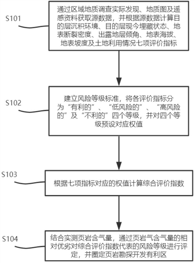
[0048] In order to make the purpose, technical solution and advantages of the present invention clearer, the embodiments of the present invention will be further described below in conjunction with the accompanying drawings.

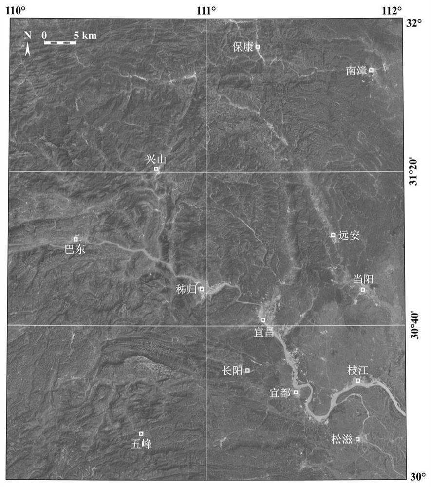
[0049] The main body of the evaluation area in this embodiment is located in the west of Hubei Province, with a geographical range of 110°-112°E, 30°-32°N, and an area of ​​about 4.2×10 4 km 2 , which belongs to the Middle Yangtze plate in terms of tectonics, has undergone multi-stage tectonic evolution cycles, and the pre-Sinian crystalline basement to the Quaternary sedimentary strata have been exposed, and the geological background is complex. The surface conditions in the area are complex, the vegetation coverage is extremely high, and the water system is densely covered. Satellite optical images such as figure 1 shown.

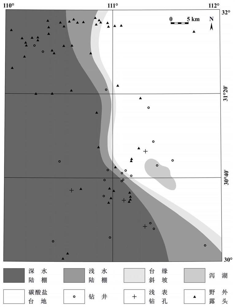
[0050]Organic-rich black shale is developed in the Lower Sinian Doushantuo Formation, Lower Cambrian Niutitang Formation, Upper ...


PUM


Abstract

The present invention provides a shale gas favorable area evaluation method based on geological survey and remote sensing data, which specifically includes: calculating the depositional environment of the target layer, the current burial state of the target layer, and There are seven evaluation indicators of surface fracture density, exposed stratum dip, surface elevation, surface slope and land use; according to the existing exploration practice experience, the establishment of standards divides each index into "favorable", "low risk", and "high risk". Risky" and "unfavorable" four grades, and assign corresponding weights; take the logarithm of the base ten as the logarithm of the weight value of each index to get the comprehensive evaluation index; combined with the measured shale gas-bearing properties, determine the comprehensive evaluation index The risk level is used to delineate the favorable areas for shale gas exploration and development; the beneficial effect of the method provided by the invention is: to carry out convenient, quantitative and comprehensive risk estimation in areas where oil and gas geological data are lacking, and to increase the number of favorable areas for shale gas exploration and development. evaluation efficiency.

Description

technical field [0001] The invention relates to the field of shale gas exploration and development, in particular to a method for evaluating favorable areas of shale gas based on geological survey and remote sensing data. Background technique [0002] There are several sets of marine organic-rich shale developed in the Sinian-Permian strata in southern my country. Their hydrocarbon source quality and reservoir performance can be compared with those of commercially successful shale formations in North America, and their huge resource potential has reached ten percent. It has been confirmed by the exploration and development work in the past years. At present, the delineation of long-term areas has been completed for each main target layer system, and it is entering the stage of evaluation of favorable areas and implementation of target areas. Preliminary studies have shown that the shale series in North America are mostly distributed in a relatively stable structural backgrou...

Claims


Application Information

Patent Timeline
Patent Type & Authority Patents(China)
IPC IPC(8): G06Q50/02E21B47/00E21B49/00
CPCE21B47/00E21B49/00G06Q50/02
Inventor 徐笑丰石万忠冯芊张晓明王任严德天
Owner CHINA UNIV OF GEOSCIENCES (WUHAN)
Why Eureka
Try Eureka