Inertia/vision/astronomy/laser ranging integrated navigation method suitable for lunar lander

A technology of laser ranging and integrated navigation, which is applied in astronomical navigation, navigation through speed/acceleration measurement, surveying and navigation, etc., and can solve the problem of low positioning accuracy

Active Publication Date: 2020-11-17
BEIHANG UNIV
View PDF8 Cites 16 Cited by
  • Summary
  • Abstract
  • Description
  • Claims
  • Application Information

AI Technical Summary

Problems solved by technology

Common types of navigation include celestial navigation and laser ranging navigation. The error of celestial navigation has nothing to do with time and distance, and the navigation attitude information can be corrected, but the positioning accuracy is not high. Laser ranging can be used to improve the navigation accuracy and better correct the lander's position. location information

Method used


Image

  • Inertia/vision/astronomy/laser ranging integrated navigation method suitable for lunar lander
  • Inertia/vision/astronomy/laser ranging integrated navigation method suitable for lunar lander
  • Inertia/vision/astronomy/laser ranging integrated navigation method suitable for lunar lander

Examples


Embodiment Construction

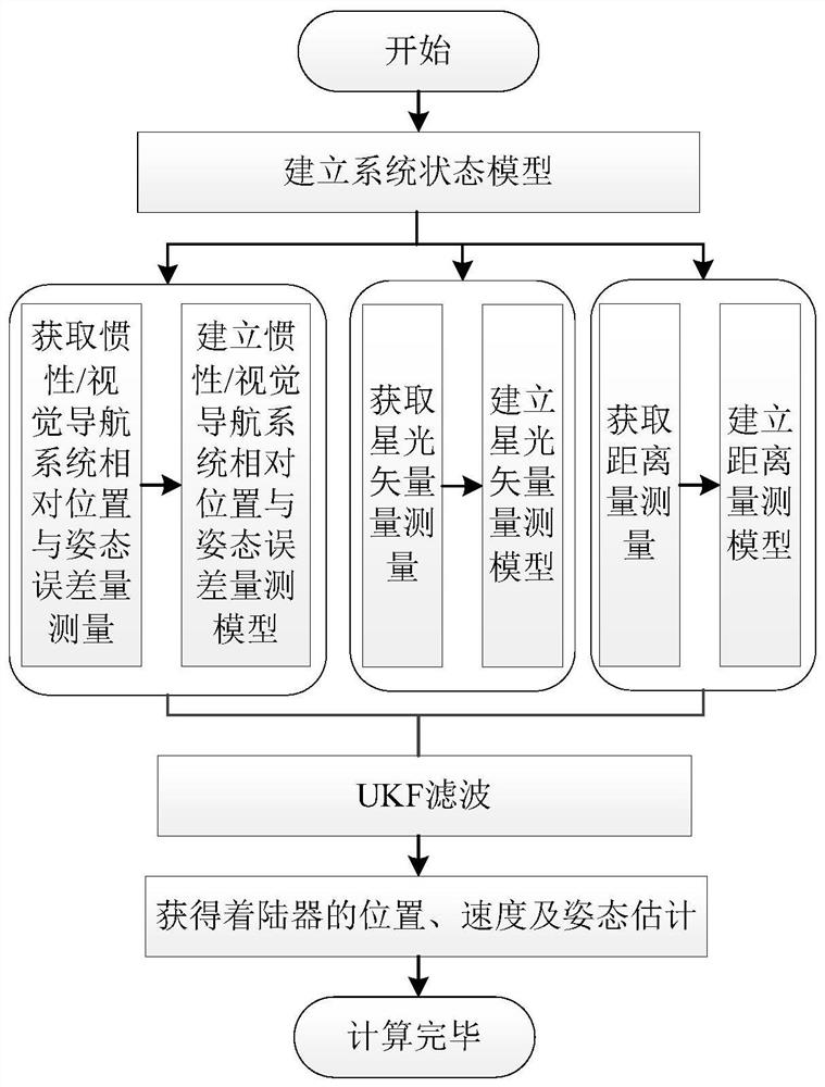
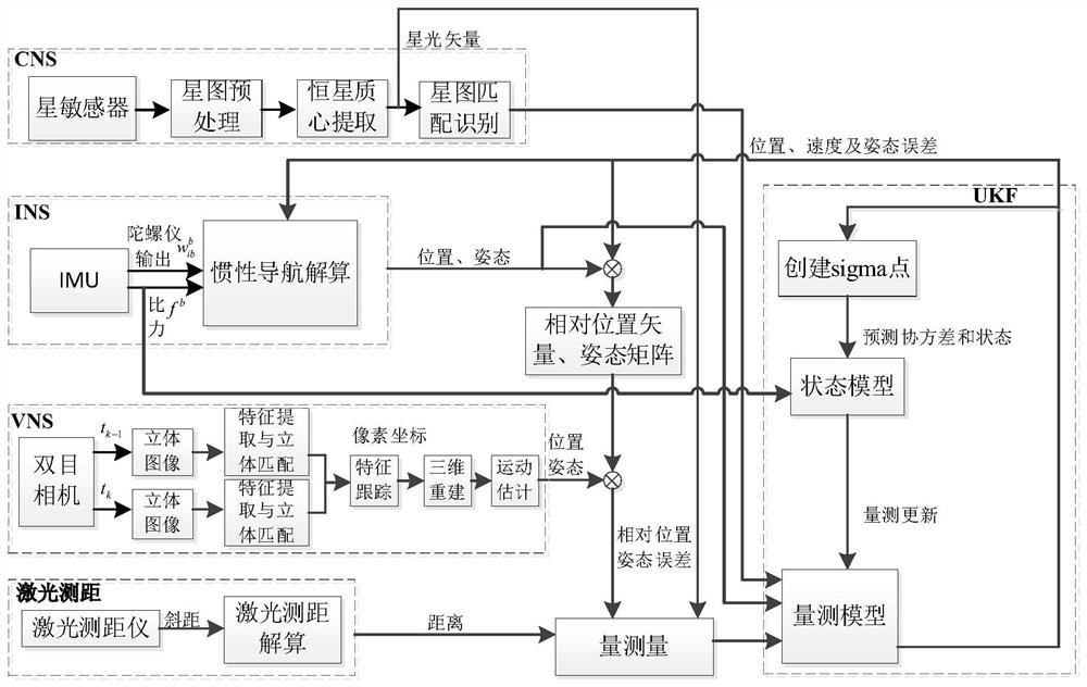
[0077] figure 1 The system flow chart of the inertial / visual / astronomical / laser ranging integrated navigation method for the lunar lander is given. Next, the specific implementation process of the present invention is described in detail:

[0078] 1. Establish a system state model based on the inertial navigation error equation

[0079] The error equation of inertial navigation in the lunar fixed coordinate system is used as the system state model:

[0080]

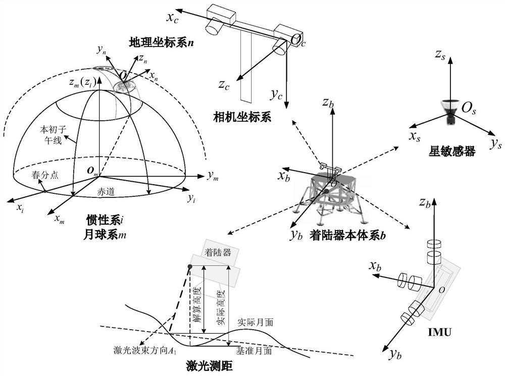
[0081] where φ=[φ E φ N φ U ] T is the attitude error angle, φ E , φ N , φ U respectively represent the geographic coordinate system of the inertial navigation system, that is, the attitude error of the east, north and sky directions in the n system; f n is the force vector under the n system; is the velocity error of the lunar lander, δ E ,δ N ,δ U Respectively represent the speed errors of the inertial navigation system in the east, north and sky directions; δr n =[δL δλ δh] T is the position error ...


PUM


Abstract

The invention relates to an inertia / vision / astronomy / laser ranging combined navigation method suitable for a lunar lander. The method includes: firstly, according to mechanical arrangement of inertialnavigation under a lunar fixed connection coordinate system, taking an inertial navigation error equation as a state model, and then taking the relative position and attitude error obtained by an inertial / visual navigation system, the starlight vector obtained by an astronomical navigation system and the distance obtained by a laser range finder as measurement quantities; then respectively establishing measurement models of relative position and attitude errors, starlight vectors and laser ranging of the inertial / visual navigation system according to the measurements; and finally, estimatingthe position, the speed and the attitude of the lander by using UKF filtering, and correcting the attitude error and the inertial device error of the lunar lander. The invention belongs to the field of deep space probe autonomous navigation, can provide high-precision position, speed and attitude information for a lunar lander, and has important practical significance for deep space detection.

Description

technical field [0001] The invention belongs to the field of autonomous navigation of deep space probes, and relates to an inertial / visual / astronomical / laser ranging combined navigation method suitable for lunar landers. Background technique [0002] As an important direction of human spaceflight activities and an important way of space science and technological innovation, deep space exploration technology is an important symbol of a country's comprehensive national strength and one of the current and future development priorities in the space field. play an important role. In recent years, my country's deep space exploration technology has developed rapidly, deep space exploration capabilities have been continuously improved, and lunar exploration has gradually improved. Taking Chang'e-4 as an example, its lander was launched into orbit on December 8, 2018, and successfully landed softly on the back of the moon at 10:26 on January 3, 2019, realizing the first soft landing...

Claims


Application Information

Patent Timeline
Patent Type & Authority Applications(China)
IPC IPC(8): G01C21/16G01C21/02G01S17/08
CPCG01C21/165G01C21/025G01S17/08
Inventor 吴伟仁宁晓琳黄玉琳
Owner BEIHANG UNIV
Why Eureka
Try Eureka