Method for separating passive microwave remote sensing mixed pixel component soil radiation signals

A passive microwave remote sensing and mixed pixel technology, which is applied in the field of microwave remote sensing, can solve the problems of spatial heterogeneity, mixed pixel surface parameter inversion, low spatial resolution, and large difference in microwave radiation.

Active Publication Date: 2020-11-24
自然资源部国土卫星遥感应用中心
View PDF4 Cites 4 Cited by
  • Summary
  • Abstract
  • Description
  • Claims
  • Application Information

AI Technical Summary

Problems solved by technology

However, since the spatial resolution of passive microwave remote sensing pixels is usually on the scale of tens of kilometers or even tens of kilometers, the spatial resolution is low, and there may be multiple types of vegetation, water bodies, bare soil, towns, etc. in the same pixel. land cover, this type of cell is called a mixed cell
Due to the large difference in the microwave radiation of different land cover types, the spatial heterogeneity brings great difficulties to the inversion of the surface parameters of mixed pixels
[0003] The main problem of traditional passive microwave remote sensing data processing is that it does not consider the difference in microwave radiation signals of different land cover types, but considers the entire mixed pixel as a whole, so that the inverted surface parameters can only be the average of mixed pixels value, which brings many uncertainties to the processing of passive microwave remote sensing data and the application of surface parameter products

Method used


Image

  • Method for separating passive microwave remote sensing mixed pixel component soil radiation signals
  • Method for separating passive microwave remote sensing mixed pixel component soil radiation signals
  • Method for separating passive microwave remote sensing mixed pixel component soil radiation signals

Examples


Embodiment 1

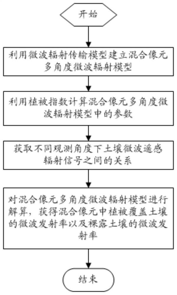
[0039] Embodiment 1, a method for separating soil radiation signals of passive microwave remote sensing mixed pixel components, such as figure 1 shown, including the following steps:

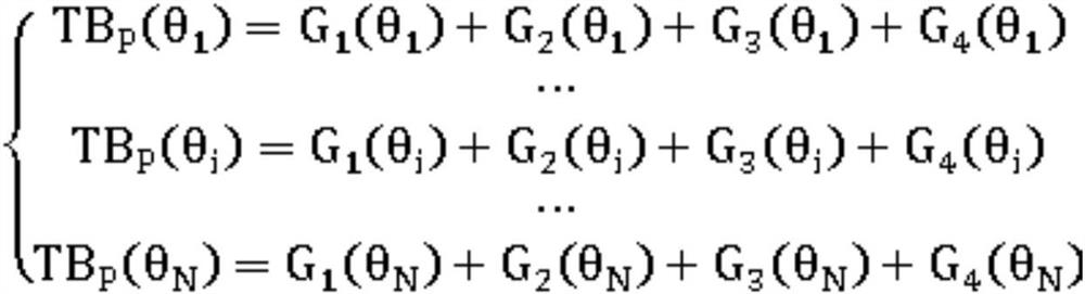
[0040] S1) establish a microwave radiation transfer model, and use the microwave radiation transfer model to establish a mixed pixel multi-angle microwave radiation model;

[0041] S2) Using the vegetation index to calculate the parameters in the mixed pixel multi-angle microwave radiation model;

[0042] S3) Establish a soil radiation simulation database and a bare soil surface emission theoretical model, and obtain the relationship between soil microwave remote sensing radiation signals under different observation angles according to the soil radiation simulation database and the bare soil surface emission theoretical model;

[0043] S4) Using the parameters in the mixed pixel multi-angle microwave radiation model in step S2) and the relationship between the soil microwave remote sensing radi...


PUM


Abstract

The invention relates to the field of microwave remote sensing, and discloses a method for separating passive microwave remote sensing mixed pixel component soil radiation signals. The method comprises the following steps: establishing a mixed pixel multi-angle microwave radiation model by using a microwave radiation transmission model; calculating parameters in the mixed pixel multi-angle microwave radiation model by utilizing vegetation indexes; acquiring the relationship between the soil microwave remote sensing radiation signals at different observation angles by utilizing a bare soil surface emission theoretical model; and resolving the mixed pixel multi-angle microwave radiation model to obtain the microwave emissivity of vegetation-covered soil in the mixed pixels and the microwaveemissivity of bare soil. According to the invention, passive microwave remote sensing multi-angle observation information is fully mined; the microwave remote sensing radiation signals of the mixed pixels are separated, the microwave emissivity of the vegetation covered soil and the emissivity of the bare soil in the mixed pixels are obtained, and the passive microwave remote sensing data processing depth, the surface parameter inversion product applicability and the product precision are improved.

Description

technical field [0001] The invention relates to the field of microwave remote sensing, in particular to a method for separating soil radiation signals of passive microwave remote sensing mixed pixel components. Background technique [0002] Microwave remote sensing is a technology that uses microwave bands to observe target scattering and radiation characteristics. Compared with optical remote sensing methods, microwave has the advantage of working all-weather and all-weather, and has a certain penetration ability to vegetation layers, and can obtain soil information under vegetation coverage. This is also one of the important advantages of microwave remote sensing for vegetation and soil parameter inversion. In addition, the passive microwave remote sensing method has the characteristics of short revisit period and low spatial resolution, which is conducive to obtaining long-term large-scale earth observation data. Therefore, the use of passive microwave remote sensing da...

Claims


Application Information

Patent Timeline
Patent Type & Authority Applications(China)
IPC IPC(8): G01R29/08G01N22/00G01N21/47G01N21/17G01J5/00
CPCG01J5/00G01N21/17G01N21/47G01N22/00G01N2021/1793G01R29/0892
Inventor 张涛王光辉戴海伦刘宇艾萍王界陆尘于瑞坤
Owner 自然资源部国土卫星遥感应用中心
Why Eureka
Try Eureka