Unmanned aerial vehicle semi-aviation time domain electromagnetic detection data analysis and interpretation method

A time-domain electromagnetic and detection data technology, applied in the field of geophysical airborne electromagnetic exploration, can solve the problems of shallow detection depth, transmitter can only provide magnetic source power, and difficult data processing

Inactive Publication Date: 2020-12-11
CHENGDU UNIVERSITY OF TECHNOLOGY
View PDF2 Cites 17 Cited by
  • Summary
  • Abstract
  • Description
  • Claims
  • Application Information

AI Technical Summary

Problems solved by technology

[0005] The ground-air transient electromagnetic survey method based on the combined magnetic source technology disclosed in this patent document is not only difficult to deploy magnetic sources in complex terrain areas such as mountains, lakes, and swamps, but also has a relatively shallow detection depth; its transmitter can only provide magnetic sources. Power; the position of the receiving coil is in the serpentine flight relative to the magnetic transmitting source, the transmitting and receiving distance and the size of the received signal are changing, and the data processing is very difficult

Method used


Image

  • Unmanned aerial vehicle semi-aviation time domain electromagnetic detection data analysis and interpretation method
  • Unmanned aerial vehicle semi-aviation time domain electromagnetic detection data analysis and interpretation method
  • Unmanned aerial vehicle semi-aviation time domain electromagnetic detection data analysis and interpretation method

Examples


Embodiment 1

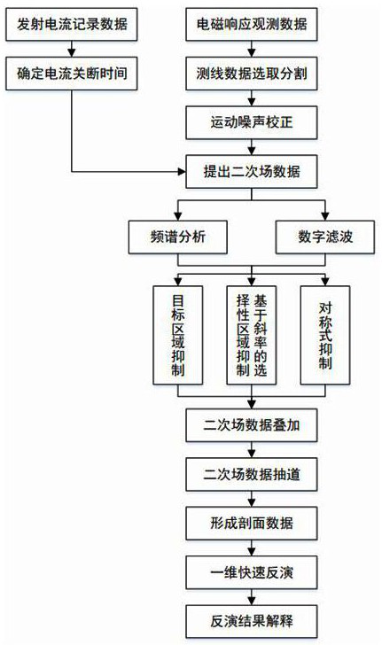
[0064] see figure 1 , a method for analysis and interpretation of unmanned aerial vehicle semi-aerial time domain electromagnetic detection data, comprising the following steps:

[0065] a. Preliminarily organize the original data through the UAV semi-aerial time-domain electromagnetic survey system, divide the observation data, select the survey line data, and preprocess the survey line data to eliminate motion noise;

[0066] b. Determine the starting point of the secondary field data according to the off time in the transmitting waveform. After determining the starting point of the secondary field data, extract the secondary field data from the survey line data, and perform spectrum analysis and digital analysis on the secondary field data filter processing;

[0067] c. Superimpose the secondary field data, and extract the superimposed secondary field data to form data to be interpreted by imaging or inversion;

[0068] d. Carry out one-dimensional rapid inversion of the ...

Embodiment 2

[0071] see figure 1 , a method for analysis and interpretation of unmanned aerial vehicle semi-aerial time domain electromagnetic detection data, comprising the following steps:

[0072] a. Preliminarily organize the original data through the UAV semi-aerial time-domain electromagnetic survey system, divide the observation data, select the survey line data, and preprocess the survey line data to eliminate motion noise;

[0073] b. Determine the starting point of the secondary field data according to the off time in the transmitting waveform. After determining the starting point of the secondary field data, extract the secondary field data from the survey line data, and perform spectrum analysis and digital analysis on the secondary field data filter processing;

[0074] c. Superimpose the secondary field data, and extract the superimposed secondary field data to form data to be interpreted by imaging or inversion;

[0075] d. Carry out one-dimensional rapid inversion of the ...

Embodiment 3

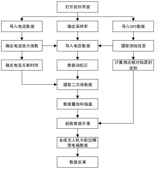
[0097] see figure 1 and figure 2 , a method for analysis and interpretation of unmanned aerial vehicle semi-aerial time domain electromagnetic detection data, comprising the following steps:

[0098] a. Preliminarily organize the original data through the UAV semi-aerial time-domain electromagnetic survey system, divide the observation data, select the survey line data, and preprocess the survey line data to eliminate motion noise;

[0099] b. Determine the starting point of the secondary field data according to the off time in the transmitting waveform. After determining the starting point of the secondary field data, extract the secondary field data from the survey line data, and perform spectrum analysis and digital analysis on the secondary field data filter processing;

[0100] c. Superimpose the secondary field data, and extract the superimposed secondary field data to form data to be interpreted by imaging or inversion;

[0101] d. Carry out one-dimensional rapid in...


PUM


Abstract

The invention discloses an unmanned aerial vehicle semi-aviation time domain electromagnetic detection data analysis and interpretation method, and belongs to the technical field of geophysical aviation electromagnetic exploration. The method comprises the following steps of a, preprocessing survey line data to eliminate a motion noise; b, performing spectral analysis and digital filtering processing on secondary field data; c, forming data to be imaged or inversely interpreted; and d, performing one-dimensional rapid inversion on the superimposed and lane-drawn secondary field data, establishing an underground electrical structure profile, and performing geological interpretation on an inversion imaging result in combination with geological data to form a comprehensive interpretation result. On the basis of ground grounding long wire source emission, an aerial unmanned aerial vehicle receives semi-aviation time domain electromagnetic detection data of an observation mode, and the method can quickly complete processing, analysis and explanation work while guaranteeing higher detection precision, and can realize quick exploration in a smaller area range.

Description

technical field [0001] The invention relates to the technical field of geophysical airborne electromagnetic exploration, in particular to a method for analyzing and interpreting electromagnetic detection data in the semi-aerial time domain of an unmanned aerial vehicle. Background technique [0002] Airborne electromagnetic method is a geophysical exploration method with high speed and wide application range. It mainly uses helicopters or fixed-wing aircraft to carry launch and observation systems. The airborne electromagnetic method is mainly used in large-scale regional geological exploration, and has a high safety risk factor. With the continuous maturity of UAV technology, the semi-aerial electromagnetic method has been produced. The semi-aerial electromagnetic method is an observation method that is launched on the ground and received by the UAV equipped with a receiving sensor in the air. Compared with the traditional airborne electromagnetic method, the semi-airborne...

Claims


Application Information

Patent Timeline
Patent Type & Authority Applications(China)
IPC IPC(8): G01V3/10G01V3/38G01C5/00
CPCG01C5/005G01V3/10G01V3/38
Inventor 王绪本余小东罗威杨聪郭明何可张振雄
Owner CHENGDU UNIVERSITY OF TECHNOLOGY
Why Eureka
Try Eureka