Infrared double-wave image and cloud early warning dike patrol flood prevention danger checking system and method

An infrared and cloud-based technology, applied in image enhancement, image analysis, image data processing, etc., to achieve efficient processing and rapid response

Pending Publication Date: 2021-01-05
埃洛克人工智能科技(南京)有限公司
View PDF0 Cites 6 Cited by
  • Summary
  • Abstract
  • Description
  • Claims
  • Application Information

AI Technical Summary

Problems solved by technology

[0003] The main purpose of this application is to provide an infrared dual-wave image and cloud early warning system and method for patrolling embankments and flood prevention to solve the current problems

Method used


Image

  • Infrared double-wave image and cloud early warning dike patrol flood prevention danger checking system and method
  • Infrared double-wave image and cloud early warning dike patrol flood prevention danger checking system and method
  • Infrared double-wave image and cloud early warning dike patrol flood prevention danger checking system and method

Examples


Embodiment 1

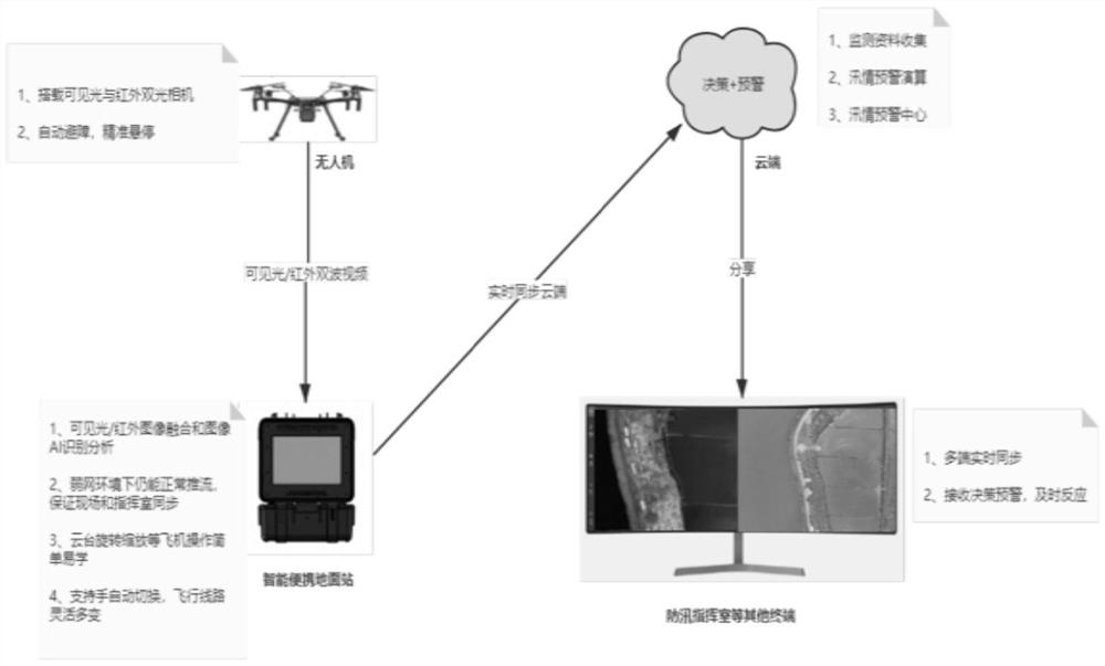
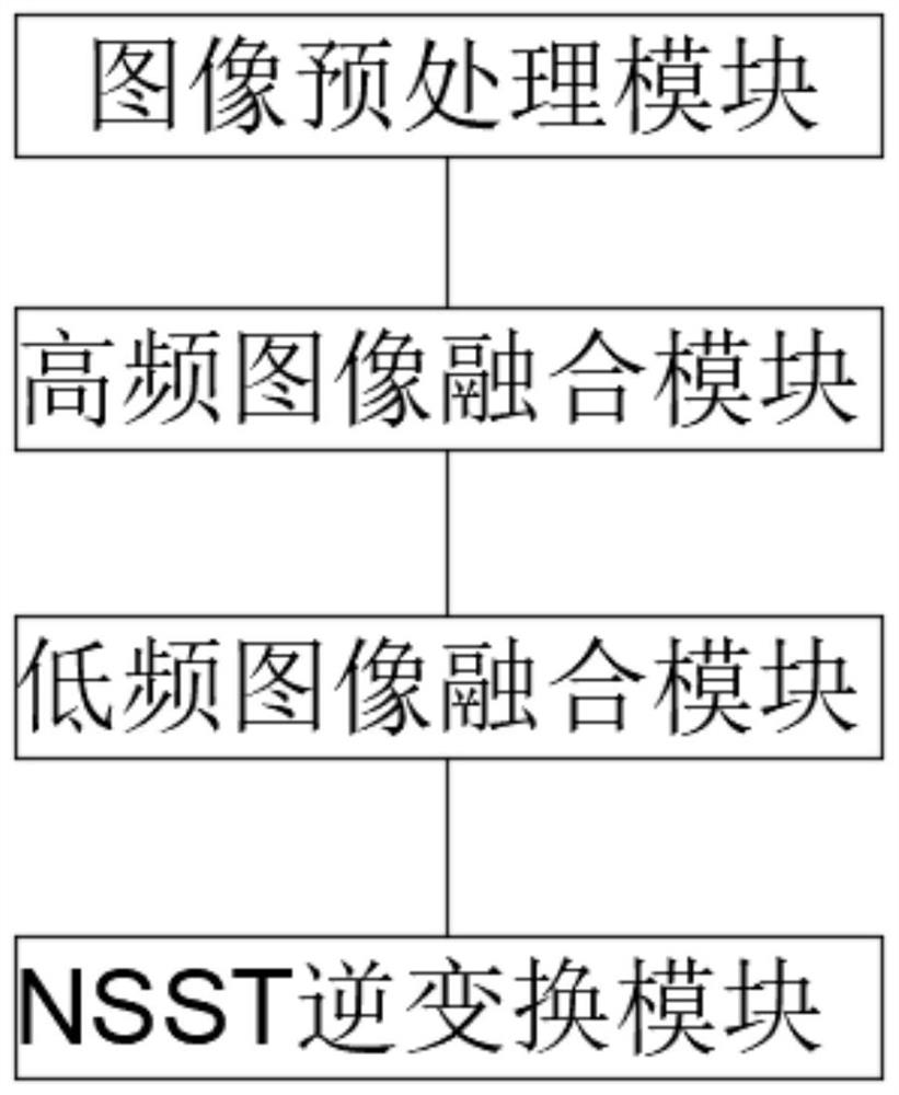
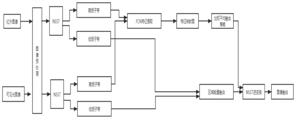
[0065] The invention carries out different sensors such as visible light and infrared dual-wave video cameras through a network of light and small unmanned aerial vehicles, and implements uninterrupted video image collection of dams around the clock, especially through the infrared thermal imaging function, which can monitor insufficient light at night, rain, fog, etc. Severe weather, and changes in ambient temperature that are difficult for other personnel to perceive. These data will be sent back to the ground station and the cloud synchronously in real time. The ground station realizes image fusion through its own AI intelligent algorithm, and calculates potential dangerous locations and hazard level coefficients through fusion image analysis and temperature difference comparison technologies. Help timely discover potential loopholes, water seepage, piping and other dangers. At the same time, the powerful cloud analysis capability supports decision-making and early warning ...


PUM


Abstract

The invention discloses an embankment system and method based on an infrared double-wave image, an intelligent portable ground station, a cloud decision early warning system and a flood prevention command terminal. Visible light and infrared cameras are carried on an unmanned aerial vehicle to quickly and efficiently complete an inspection task, and the ground station realizes image fusion througha built-in AI intelligent algorithm; through image analysis, temperature difference comparison and other technologies, a potential dangerous place and a danger level coefficient are obtained throughoperation, and bad weather such as insufficient light, rain and fog at night and environment temperature changes difficult to perceive can be monitored; rapid response and efficient disposal can be ensured in case of danger, and a protective barrier is built for life and property safety of resident people; powerful cloud AI analysis capability and mass storage capability support decision-making and early warning functions, dam holes, water seepage and the like are discovered as soon as possible, and precious time is gained for early response; and multi-terminal synchronization is supported, flood prevention command rooms, sites and other places synchronously monitor flood situations in a sharing mode, and convenience is achieved.

Description

technical field [0001] This application relates to the technical field of technical flood control communication surveying and mapping, in particular, it relates to a system and method for patrolling embankments and preventing floods with infrared dual-wave images and early warning in the cloud. Background technique [0002] The embankment is a barrier against floods. Once a large flood occurs, various dangers are prone to occur, especially a series of dangers such as leaks, piping, and water seepage. Therefore, it is necessary to have modern and new means of patrolling embankments that can analyze and deal with the situation. Early detection, quick disposal of dangerous situations, and quick response to pipelines. At present, the traditional way of patrolling embankments is mainly a large number of manpower inspections. This kind of embankment inspection is blind and easily affected by human factors. Especially at night, it is more difficult to patrol embankments. Not only c...

Claims


Application Information

Patent Timeline
Patent Type & Authority Applications(China)
IPC IPC(8): G06T7/00G06K9/62G06Q50/26G08B21/10
CPCG06T7/0002G06Q50/26G08B21/10G06T2207/10048G06T2207/10052G06T2207/20221G06T2207/30192G06T2207/20081G06T2207/20084G06F18/213Y02A10/40Y02A50/00
Inventor 赵长青张春雷狄效国吴敏
Owner 埃洛克人工智能科技(南京)有限公司
Why Eureka
Try Eureka