Lake water volume space-time change analysis method and device based on multi-source satellite data

A satellite data, space-time change technology, applied in the direction of nuclear method, image analysis, image data processing, etc., can solve the problems of unsatisfactory efficiency and slow learning speed, and achieve fast calculation speed, low calculation speed and high accuracy Effect

Pending Publication Date: 2021-01-08
TONGJI UNIV
View PDF6 Cites 2 Cited by
  • Summary
  • Abstract
  • Description
  • Claims
  • Application Information

AI Technical Summary

Problems solved by technology

Although the neural network has a strong learning ability, its learning speed is relatively slow and it

Method used


Image

  • Lake water volume space-time change analysis method and device based on multi-source satellite data
  • Lake water volume space-time change analysis method and device based on multi-source satellite data
  • Lake water volume space-time change analysis method and device based on multi-source satellite data

Examples


Embodiment 1

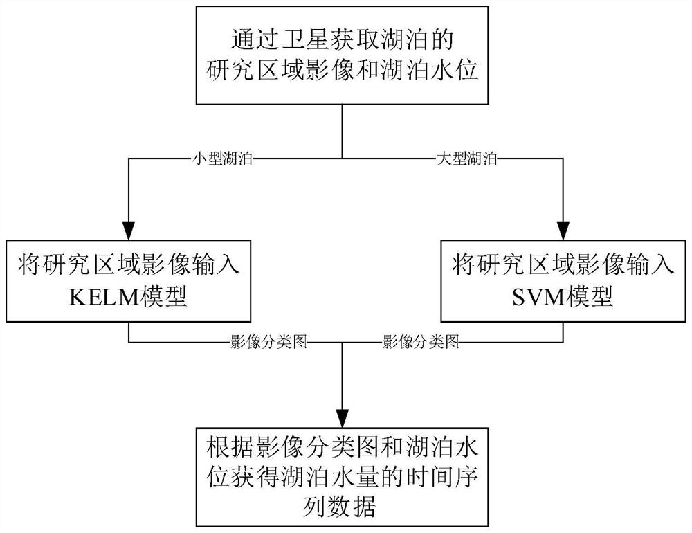
[0072] A method for analyzing temporal and spatial changes of lake water volume based on multi-source satellite data, such as figure 1 ,Specifically:

[0073] S1: Obtain images of the study area of ​​the lake through satellites, classify water bodies and non-water bodies in the images of the study area, obtain image classification maps, and obtain lake water levels through satellites;

[0074] S2: According to the image classification map of the lake and the water level of the lake, the time series data of the water volume of the lake is obtained by geometric analysis;

[0075] Wherein, the specific process of step S1 is:

[0076] According to the prior information, the lakes are divided into small lakes and large lakes. If the lake is a small lake, input the image of the research area of ​​the lake into the trained KELM model to obtain the image classification map, otherwise input the image of the research area of ​​the lake into the training A good SVM model, to obtain ima...

Embodiment 2

[0138] In step S2 of this embodiment, the time series data of lake water volume are obtained by using physical analysis method according to the image classification map of the lake and the lake water level, and the others are the same as in embodiment 1.

[0139] The physical analysis method is based on the GRACE satellite, combined with the least squares mathematical model and the best prior test model, specifically:

[0140] Divide Lake Victoria into 4 sub-basins, the mathematical model of the least square method is:

[0141]

[0142] Among them, y t (x) is the surface quality of each watershed, x is the geographic location coordinates, α t is the unified scaling factor, α tj for the jth α t , Ω is the research area, ε t (x) is the fitting error, b j (x) is the watershed coefficient of each sub-basin, and the calculation formula is:

[0143]

[0144] Among them, inside basin represents that the geographic location coordinates are located within the sub-basin, and...

Embodiment 3

[0156] An analysis device adopting the analysis method in Embodiment 1 includes a memory and a processor, the memory stores a computer program, and the processor invokes the program instructions to execute any method.

[0157] Embodiment 1, Embodiment 2 and Embodiment 3 propose a method and device for analyzing temporal and spatial changes of lake water volume based on multi-source satellite data, which breaks through the bottleneck of lack of surface hydrological observation data and underwater lake basin measurement data, and can quickly and periodically Accurately obtain the change of lake area and water level, which provides a convenient means for mastering the dynamic change law of lakes, dynamic monitoring and protection of water resources, and has important scientific significance for timely grasping the regional water balance and sustainable use of water resources. Significance and application value; joint multi-source satellite observation data can effectively obtain r...


PUM


Abstract

The invention relates to a lake water volume space-time change analysis method and device based on multi-source satellite data, and the method specifically comprises the steps: S1, obtaining a research region image of a lake through a satellite, preprocessing the research region image, obtaining an image classification map, and obtaining the lake water level through the satellite; and S2, obtaining time series data of the lake water quantity according to the image classification map of the lake and the lake water level, inputting the research area image of the small lake into a KELM model to obtain an image classification map, and inputting the research area image of the large lake into a trained SVM model to obtain an image classification map; the training process comprises the followingsteps: collecting an experimental area image, dividing pixel points on the experimental area image into a water body and a non-water body to form a training sample, training a KELM model and an SVM model by using the training sample, and performing parameter optimization on the KELM model by using a PSO algorithm. Compared with the prior art, the method has the advantages of good stability, good robustness, high efficiency and the like.

Description

technical field [0001] The invention relates to a lake water volume monitoring technology, in particular to a method and device for analyzing temporal and spatial changes of lake water volume based on multi-source satellite data. Background technique [0002] The change of lake water volume is the main controlling factor for establishing the water balance relationship of lakes and then analyzing the water balance in different climate regions. It is of great scientific significance for studying the impact of climate change and human activities on the regional water cycle. A lake is a complex water cycle system, and each hydrological process in the system has uncertainty, which brings great difficulties to improve the accuracy of the research on the change of lake water volume. The traditional water resources survey has a variety of technical means based on hydrological observation stations, combined with topographic data of the lake bottom and field observation data to calcul...

Claims


Application Information

Patent Timeline
IPC IPC(8): G06K9/00G06K9/46G06K9/62G06T7/62G06N3/00G06N3/04G06N3/08G06N20/10
CPCG06T7/62G06N3/006G06N3/08G06N20/10G06T2207/10032G06T2207/30181G06V20/13G06V10/40G06N3/045G06F18/2411
Inventor 林怡超能芳李鑫张婷慧宇洁叶勤谢光顺张文豪
Owner TONGJI UNIV
Why Eureka
Try Eureka