
Regional danger coefficient evaluation method using unmanned aerial vehicle oblique photography image

A technology of oblique photography and risk factor, which is applied to unmanned aerial vehicles, image data processing, details involving 3D image data, etc. It can solve the problems of risk factor evaluation in difficult-to-monitor areas, inconspicuous disaster characteristics, and increased detection difficulty. , to achieve the effect of reducing complex background interference, reducing missed detection rate and high accuracy

Active Publication Date: 2021-02-09
CHINA HIGHWAY ENG CONSULTING GRP CO LTD +1
View PDF9 Cites 6 Cited by
  • Summary
  • Abstract
  • Description
  • Claims
  • Application Information

AI Technical Summary

Problems solved by technology

This traditional method has the following defects: when the geological disaster is located on a slope with a large slope, the area in the orthophoto image is small, the disaster features are not obvious, and it is easy to cause missed detection; when the background of the geological disaster area is complex, it will lead to Increased difficulty of detection
And after the traditional detection, only the area of ​​geological hazards can be obtained, and it is difficult to evaluate the overall risk coefficient of the monitoring area

Method used


Image

  • Regional danger coefficient evaluation method using unmanned aerial vehicle oblique photography image
  • Regional danger coefficient evaluation method using unmanned aerial vehicle oblique photography image
  • Regional danger coefficient evaluation method using unmanned aerial vehicle oblique photography image

Examples


Embodiment Construction

[0018] The present invention will be described in further detail below in conjunction with the accompanying drawings.

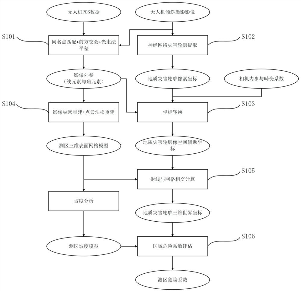
[0019] like figure 1 As shown, the present invention utilizes the regional risk factor evaluation method of UAV oblique photography image, comprises the following steps:

[0020] S101: Perform point matching, forward intersection, and beam adjustment on the overlapping area of ​​the oblique photography image of the UAV and the pose of each image obtained by the UAV POS system, so as to obtain accurate extrinsic parameters (lines) of each image element and corner element).

[0021] S102: For the original image data of the oblique photographic image in step 1, use a multi-scale fully convolutional neural network that takes context information into account to segment the image so as to accurately extract pixel coordinates of the contour of the geological disaster. The above neural network has added a weighted attention mechanism module for detecting geological...


PUM


Abstract

The invention discloses a regional danger coefficient evaluation method using an unmanned aerial vehicle oblique photography image. The method comprises the following steps: detecting a geological disaster region from the oblique photography image by using a deep learning image segmentation method, resolving the real geographic position of the disaster region based on accurate external parametersobtained by the adjustment of an unmanned aerial vehicle image bundle method, and analyzing the danger coefficient of the monitoring region by further combining the area and gradient data of the detection disaster. Compared with the traditional method, the method has the advantages that the landslide is detected by utilizing the original photo data, so that the detection rate of the landslide is higher, and the danger coefficient of the detection region can be output.

Description

technical field [0001] The invention belongs to the field of geological exploration, and relates to a method for evaluating regional risk coefficients by using oblique photographic images of unmanned aerial vehicles. Background technique [0002] At present, the traditional method of interpreting geological disasters from UAV images is to densely match the images to obtain DOM and DSM, and then perform stitching and digital correction processing to obtain orthophotos. Then, according to the orthophoto, the geological disaster area in the orthophoto is detected by means of dependent feature design and machine learning, and then the regional safety assessment is completed. This traditional method has the following defects: when the geological disaster is located on a slope with a large slope, the area in the orthophoto image is small, the disaster features are not obvious, and it is easy to cause missed detection; when the background of the geological disaster area is complex,...

Claims


Application Information

Patent Timeline
Patent Type & Authority Applications(China)
IPC IPC(8): G01C11/00G01C11/04G06N3/04G06T17/20B64C39/02
CPCG01C11/00G01C11/04G06T17/20B64C39/02G06T2200/04G06N3/045B64U2101/30
Inventor 张蕴灵傅宇浩杨璇龚婷婷陈志杰孙雨崔丽宋张亮郭沛张鹏
Owner CHINA HIGHWAY ENG CONSULTING GRP CO LTD
Learn More