Mobile robot navigation and positioning system based on GNSS/INS/LIDAR-SLAM information fusion

A mobile robot, navigation and positioning technology, applied in the field of robot navigation, can solve the problems of reduced accuracy, large amount of calculation, and reduced matching data, etc., to achieve the effect of improving accuracy, small amount of calculation, and preventing infinite growth

Active Publication Date: 2021-02-12
WUXI KALMAN NAVIGATION TECH CO LTD
View PDF5 Cites 12 Cited by
  • Summary
  • Abstract
  • Description
  • Claims
  • Application Information

AI Technical Summary

Problems solved by technology

Point-based matching directly searches and matches the corresponding points in the lidar data, which has high precision and does not depend on environmental features, but it has a large amount of calculation and is difficult to apply to embedded computing platforms.
Feature-based matching pre-extracts environmental features, such as corners, planes, etc., which greatly reduces the matching data, with fast calculation and high precision, but it relies on environmental features and cannot operate normally in an environment with few features.
Matching based on probability distribution usually uses a three-dimensional occupancy grid map. The distribution of objects in the environment is represented by the probability of the three-dimensional grid being occupied, which avoids direct matching of points and reduces the amount of calculation. For general embedded computing platforms, the amount of calculation Still too large, if you want to further reduce the amount of calculation, you need to increase the grid size, which will lead to a decrease in accuracy
[0005] In addition, the existing mobile robot navigation and positioning systems are mostly aimed at complex urban high-rise environments, and unfamiliar outdoor environments where there are relatively open spaces, few moving objects, and GNSS positioning is reliable most of the time, or where complex environments and open environments meet. Requires a specific targeting method to meet actual needs

Method used


Image

  • Mobile robot navigation and positioning system based on GNSS/INS/LIDAR-SLAM information fusion
  • Mobile robot navigation and positioning system based on GNSS/INS/LIDAR-SLAM information fusion
  • Mobile robot navigation and positioning system based on GNSS/INS/LIDAR-SLAM information fusion

Examples


Embodiment 1

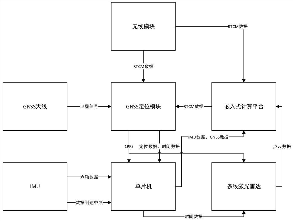
[0036] Such as figure 1 As shown, a mobile robot navigation and positioning system based on GNSS / INS / LIDAR-SLAM information fusion, its hardware consists of: GNSS antenna, GNSS positioning module, wireless module, embedded computing platform, IMU, multi-line laser radar, single-chip microcomputer .

[0037] The GNSS antenna is connected to the GNSS positioning module, and the GNSS antenna receives satellite navigation signals and transmits them to the GNSS positioning module.

[0038] The wireless module is selected from one of including but not limited to WIFI module, Bluetooth module, 4G module, and 2.4G data transmission module. The wireless module is connected to the GNSS positioning module and the embedded computing platform, and can receive differential message data (RTCM) wirelessly. And send to GNSS positioning module and embedded computing platform.

[0039] The GNSS positioning module receives satellite navigation signals through the GNSS antenna, receives RTCM dat...

Embodiment 2

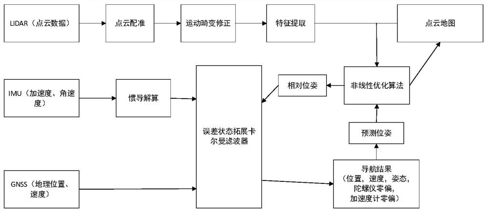
[0079] We used the intelligent platform controller produced by Wuxi Kallman Navigation Technology Co., Ltd. to conduct experiments. The controller contains Nvidia's Jetson Nano embedded computing module (4-core A57, 4GB LPDDR4 memory), STM32F107 single-chip microcomputer, Openimu330B (IMU), Unicore 4B0 (GNSS module), EC20 (4G communication module), LS LIDAR C16 (16-line laser radar), etc. Jetson Nano runs the Linux operating system, obtains RTCM data through the 4G communication module, and sends the data to the GNSS module through the serial port. The STM32 obtains the IMU data through the SPI interface, obtains the GNSS module data through the serial port, adds the time scale and sends it to the Jetson Nano through the serial port, and sends the time data to the 16-line lidar through another serial port. Jetson Nano obtains IMU and GNSS data through the serial port of STM32, and obtains lidar data through the Ethernet interface. On the Linux system of Jetson Nano, ROS (Robo...


PUM


Abstract

The invention discloses a mobile robot navigation and positioning system based on GNSS/INS/LIDARSLAM information fusion, and belongs to the field of robot navigation. According to the system, an extended Kalman filter is adopted to fuse a GNSS positioning result, IMU data and a relative pose of the mapping positioning of a laser radar, so as to obtain a positioning result of a mobile robot. For anSLAM algorithm with a large calculation performance requirement, the system adopts a 3D laser radar SLAM technology based on feature extraction, and the calculation amount of point cloud matching isreduced through feature pre-extraction, so that the navigation and positioning system can operate on an embedded platform.

Description

technical field [0001] The invention relates to a mobile robot navigation and positioning system based on GNSS / INS / LIDAR-SLAM information fusion, belonging to the field of robot navigation. Background technique [0002] With the rapid development of unmanned driving technology and intelligent robots, three positioning systems, GNSS, IMU, and LIDAR, have been widely researched and applied in the field of unmanned driving. [0003] The positioning based on the global navigation satellite system (GNSS) is easily affected by occlusion and multipath, resulting in a decrease in positioning accuracy, or even inability to locate; the inertial measurement unit (IMU) can continuously provide relative positioning in a short period of time, but the positioning error will change with time. The rapid accumulation of time becomes larger; for unfamiliar environments, fusion positioning and mapping technology (SLAM) is widely used, and the SLAM system can gradually establish maps and positio...

Claims


Application Information

Patent Timeline
Patent Type & Authority Applications(China)
IPC IPC(8): G01C21/16G01S19/48G01S19/49G08C17/02
CPCG01C21/165G01S19/48G01S19/49G08C17/02
Inventor 吴飞汤冯炜王烁陈向东
Owner WUXI KALMAN NAVIGATION TECH CO LTD
Why Eureka
Try Eureka