Satellite remote sensing quantitative evaluation method for intertidal zone erosion and deposition conditions caused by offshore wind turbines

A technology of satellite remote sensing and quantitative evaluation, which is applied in satellite radio beacon positioning systems, measuring devices, computer components, etc., can solve the problem of chaotic tide height trend at the water's edge, densely distributed in the intertidal zone, and DEM cannot effectively reflect Distribution and changes, etc., to achieve the effect of improving the fragmentation of terrain and improving the overall undulation trend

Pending Publication Date: 2021-02-19
NANJING NORMAL UNIVERSITY
View PDF0 Cites 2 Cited by
  • Summary
  • Abstract
  • Description
  • Claims
  • Application Information

AI Technical Summary

Problems solved by technology

However, when the conventional remote sensing water edge method is applied to the construction of DEM in the intertidal zone, especially for the analysis of tidal flat scouring and silting caused by small targets such as offshore wind turbines, there are the following technical problems: 1) The emergence of a large number of multi-source remote sensing data , so that the extracted instantaneous water edge is densely distributed in the intertidal zone
Due to the large dynamic changes in the tidal flats in the intertidal zone, the densely distributed water edges intersect with each other, especially in the low tide area; 2) There may be chaotic tide high trends between the densely distributed water edges, which affects the generated DEM in expressing terrain The ups and downs trend is wrong, and the DEM generated at the same time is seriously fragmented. The offshore wind turbine may be located in the tidal creek of the intertidal tidal flat. The DEM constructed by the existing method cannot effectively reflect the tidal furrow distribution and changes on the tidal flat.

Method used


Image

  • Satellite remote sensing quantitative evaluation method for intertidal zone erosion and deposition conditions caused by offshore wind turbines
  • Satellite remote sensing quantitative evaluation method for intertidal zone erosion and deposition conditions caused by offshore wind turbines
  • Satellite remote sensing quantitative evaluation method for intertidal zone erosion and deposition conditions caused by offshore wind turbines

Examples


Embodiment Construction

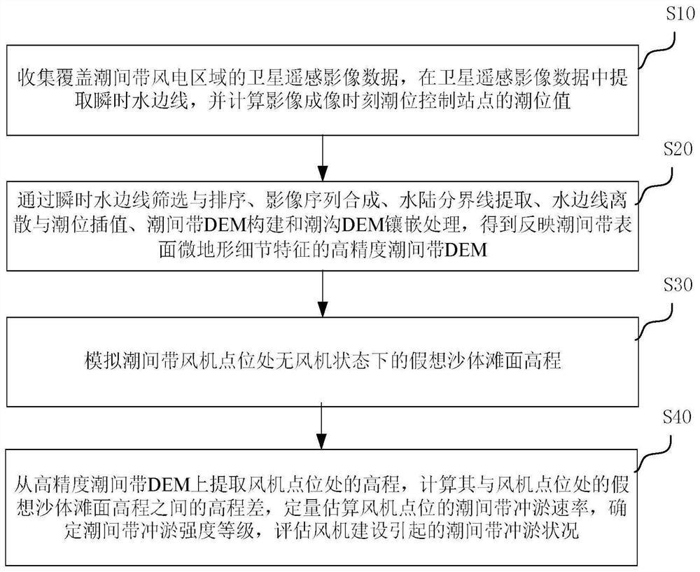
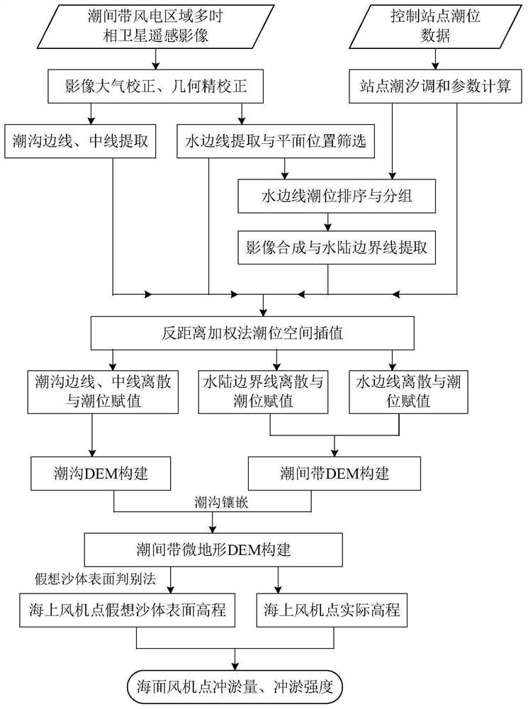
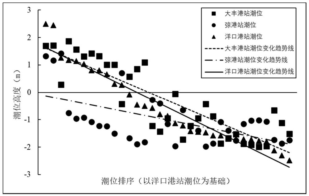
[0062] In order to make the purpose, technical solution and advantages of the present application clearer, the present application will be further described in detail below in conjunction with the accompanying drawings and embodiments. It should be understood that the specific embodiments described here are only used to explain the present application, and are not intended to limit the present application.

[0063] Reference herein to an "embodiment" means that a particular feature, structure, or characteristic described in connection with the embodiment can be included in at least one embodiment of the present application. The occurrences of this phrase in various places in the specification are not necessarily all referring to the same embodiment, nor are separate or alternative embodiments mutually exclusive of other embodiments. It is understood explicitly and implicitly by those skilled in the art that the embodiments described herein can be combined with other embodiment...


PUM


Abstract

The invention discloses a satellite remote sensing quantitative evaluation method for an intertidal zone erosion and deposition condition caused by an offshore wind turbine, and the method comprises the steps that a high-precision DEM reflecting the detail features of the surface microtopography of an intertidal zone is constructed through an improved remote sensing waterline method; an imaginarysand body surface discrimination method is further creatively provided, and the imaginary sand body beach face elevation under the draught-fan-free state at the draught fan point position of the intertidal zone is simulated; secondly, the elevation of the draught fan point position is extracted from the high-precision intertidal zone DEM, the elevation difference between the elevation of the draught fan point position and the elevation of an imaginary sand body beach face at the draught fan point position is calculated, the intertidal zone scouring and silting rate of the draught fan point position is quantitatively estimated, and the intertidal zone scouring and silting intensity grade caused by draught fan construction is evaluated. The method provides a feasible scheme for monitoring and evaluating the intertidal zone topographic change caused by intertidal zone wind power plant construction by using a satellite remote sensing technology, and also provides a technical support for analyzing the intertidal zone topographic change caused by an offshore small target object based on DEM data.

Description

technical field [0001] The invention relates to the technical field of marine engineering monitoring, in particular to a satellite remote sensing quantitative evaluation method for scour-silting conditions in intertidal zones caused by offshore wind turbines. Background technique [0002] With the rapid development of the world economy, the use of a large amount of fossil fuels has exacerbated global warming and affected the world's energy security. As a clean energy, wind energy has been widely concerned. Offshore wind turbines are mainly distributed in intertidal shoals or shallow sea areas with a water depth of 5 meters to 50 meters along the coast of 10 kilometers. The construction of offshore wind turbines will inevitably affect the tidal movement and sediment transport state in shallow seas, and affect the erosion and deposition of intertidal terrain, which may affect the stability of intertidal sand bodies and the change of intertidal habitats. At present, the analy...

Claims


Application Information

Patent Timeline
Patent Type & Authority Applications(China)
IPC IPC(8): G06K9/00G06T7/13G06T7/136G06T17/05G01S19/13
CPCG06T7/13G06T7/136G06T17/05G01S19/13G06T2207/30181G06V20/13Y02A90/10
Inventor 张东周永邓慧丽
Owner NANJING NORMAL UNIVERSITY
Why Eureka
Try Eureka