Vehicle-mounted laser pavement point cloud thinning method capable of reserving spatial characteristics

A space-reserving, vehicle-mounted laser technology, applied in image analysis, instrumentation, computing, etc., can solve problems such as single identification method, slow topological relationship, and point cloud holes

Active Publication Date: 2021-03-09
SHANDONG UNIV OF SCI & TECH
View PDF4 Cites 5 Cited by
  • Summary
  • Abstract
  • Description
  • Claims
  • Application Information

AI Technical Summary

Problems solved by technology

High-precision, high-density road surface point cloud data is helpful for the fine expression of road surface terrain features, but there is data redundancy in smooth areas, which is not conducive to data display and 3D reconstruction. Therefore, it is necessary to strategically thin out the road surface point cloud
[0004] In the process of realizing the present invention, the inventor found that the existing methods have the following deficiencies: the

Method used


Image

  • Vehicle-mounted laser pavement point cloud thinning method capable of reserving spatial characteristics
  • Vehicle-mounted laser pavement point cloud thinning method capable of reserving spatial characteristics
  • Vehicle-mounted laser pavement point cloud thinning method capable of reserving spatial characteristics

Examples


Embodiment 1

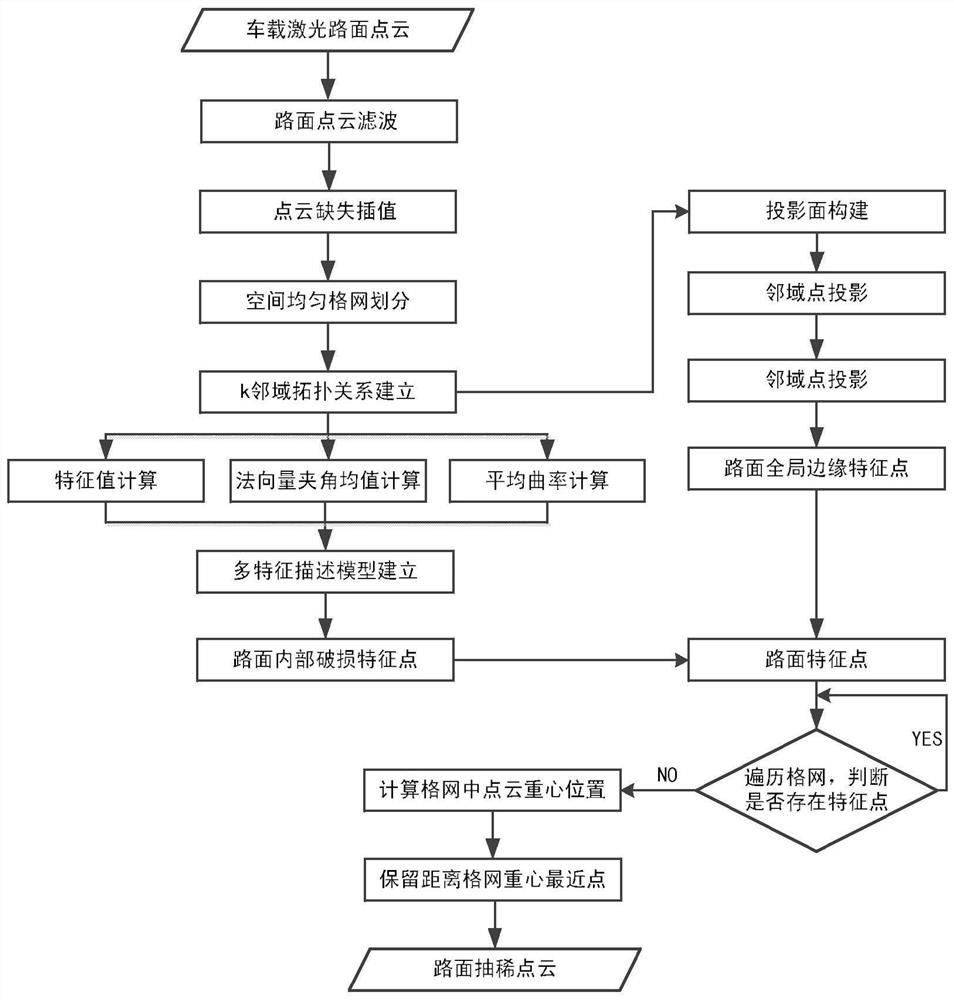
[0117] Such as figure 1 As shown, the vehicle-mounted laser road surface point cloud thinning method that preserves spatial features mainly includes the following steps:

[0118] 1. Preprocess the original road point cloud data, remove the road noise point cloud and interpolate the missing road point cloud;

[0119] 1) Road noise point filtering

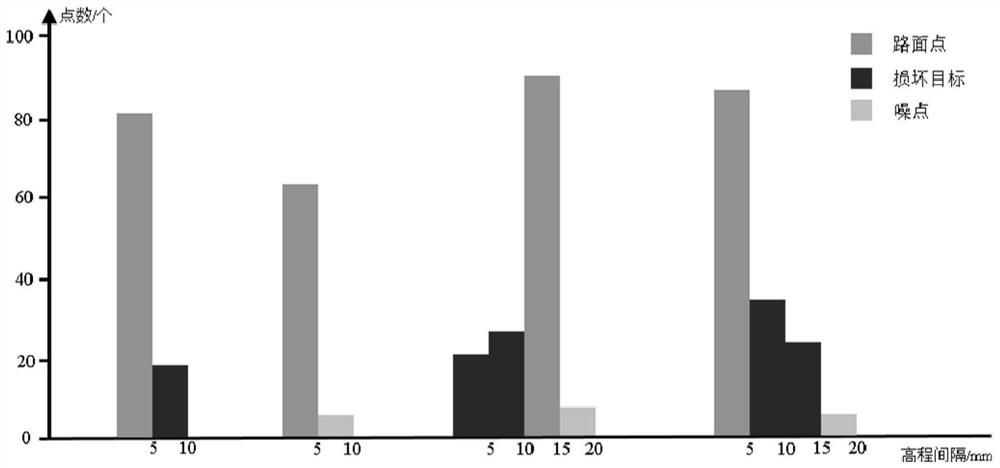
[0120] Set statistics window D side , use the histogram to count the elevation value of the road surface point cloud in each window, and divide the elevation value with the minimum detection depth of road surface damage (5mm) as the elevation interval. According to the above statistical rules, remove the road surface points in the histogram. All points in the interval of 1 / 10 of the road surface point cloud in the statistics window, where the road surface points are the bars referred to in the statistical histogram, such as figure 2 , not a single point.

[0121] 2) Missing interpolation of road surface point cloud

[0122] Est...


PUM


Abstract

The invention discloses a vehicle-mounted laser pavement point cloud thinning method capable of reserving spatial characteristics. Firstly, preprocessing such as denoising and missing interpolation iscarried out on road surface point cloud; establishing a multi-scale grid for the pavement point cloud data, constructing a spatial hybrid index in combination with a KD tree, and quickly constructinga k neighborhood topological relation of data points; performing weighted principal component analysis and least square surface fitting on k neighborhoods of the data points, calculating a feature description subset, constructing a multi-feature description model by utilizing the feature description subset, performing pavement roughness analysis, and adaptively extracting pavement internal damagefeature points; extracting global edge feature points of the pavement by utilizing a distribution uniformity constraint method of the point cloud; and finally, for a non-feature region, performing secondary thinning by using a uniform grid gravity center method, and fusing the point cloud after secondary thinning with the feature points to complete thinning.

Description

technical field [0001] The invention relates to a vehicle-mounted laser road surface point cloud extraction method for preserving spatial characteristics, and relates to the technical field of vehicle-mounted mobile measurement data road surface disease detection and data reduction. Background technique [0002] With the rapid development of highway transportation, my country's highways have reached a high degree of coverage. In the future, the maintenance of the built roads will be one of the priorities. Due to the influence of extreme conditions such as rain, snow, high temperature, and overloading, the local road surface is deformed, forming various road surface damages such as cracks, looseness, wrapping, and pit sinking. Pavement damage reduces the overall smoothness of the pavement, affects the performance of the pavement, and brings great traffic safety hazards. [0003] At present, the traditional two-dimensional pavement measurement technology measurement and manu...

Claims


Application Information

Patent Timeline
IPC IPC(8): G06T17/00G06T17/20G06T7/66G06K9/46
CPCG06T17/005G06T17/20G06T7/66G06V10/44Y02T90/00
Inventor 刘如飞杨继奔柴永宁丁少鹏
Owner SHANDONG UNIV OF SCI & TECH
Why Eureka
Try Eureka