Spatial-temporal data management method and system, host and computer readable storage medium

A spatiotemporal data and management method technology, applied in the field of data processing, can solve problems such as insufficient horizontal expansion capability, increased retrieval time, and no consideration of fragmented storage, so as to facilitate index sorting and retrieval, reduce input and output loads, and reduce search results. The effect of address targeting time

Pending Publication Date: 2021-06-25
湖南省第二测绘院
View PDF7 Cites 1 Cited by
  • Summary
  • Abstract
  • Description
  • Claims
  • Application Information

AI Technical Summary

Problems solved by technology

[0003] However, when reading geographic information data, using the index rules of relational databases for retrieval can no longer meet the management needs of massive spatio-temporal data. There is an upper limit for input and output (IO), which cannot meet the needs of efficient storage of massive spatio-temporal data. It needs to be processed simultaneously with multiple servers. Due to the design characteristics of relational databases, fragmented storage is not considered, and it does not have good native horizontal expansion capabilities. The performance of multiple servers cannot be better utilized; the second is the limitation of index performance. When the amount of data increases, the retrieval time will also increase, and the retrieval performance cannot be improved simply by adding servers
[0004] Therefore, the above related technologies store spatio-temporal data in a relational database, which cannot meet the storage requirements of massive spatio-temporal data, and the efficiency of retrieving spatio-temporal data in the database is low.

Method used


Image

  • Spatial-temporal data management method and system, host and computer readable storage medium
  • Spatial-temporal data management method and system, host and computer readable storage medium
  • Spatial-temporal data management method and system, host and computer readable storage medium

Examples


Embodiment 1

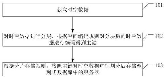
[0061] refer to figure 1 , the execution steps of this method include:

[0062] 101. Obtain spatio-temporal data.

[0063] Among them, in the field of geographic information, spatiotemporal data mainly includes vector data and image data.

[0064] 102. Layer the spatio-temporal data, and encode the layered spatio-temporal data according to the spatial coding rules to obtain the primary key.

[0065] Among them, the spatio-temporal data is divided into different precisions and uses, so it is necessary to layer the spatio-temporal data first, and the spatio-temporal data of different levels are encoded using the spatial coding rules to obtain the primary key. Each primary key corresponds to specific spatiotemporal data.

[0066] 103. According to the shard storage rules, the spatio-temporal data is divided according to the primary key and then stored to the server in the columnar database.

[0067] Among them, the columnar database can be a distributed columnar database with...

Embodiment 2

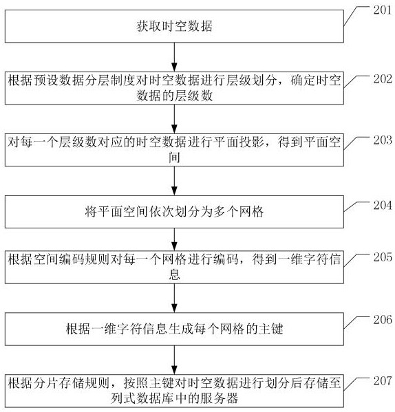
[0070] refer to figure 2 The difference between this embodiment and the above embodiment 1 is that step 102 in embodiment 1 is described in detail, and the specific execution steps include:

[0071] 201. Acquire spatio-temporal data.

[0072] 202. Divide the spatio-temporal data into layers according to the preset data layering system, and determine the number of layers of the spatio-temporal data.

[0073] Among them, the preset data layering system is based on the accuracy and use of spatio-temporal data, and the preset layering judgment principle, for example, the higher the data accuracy, the larger the number of layers. The level number L of spatio-temporal data can be determined by classifying the spatio-temporal data according to the preset data stratification system.

[0074] 203. Perform planar projection on the spatio-temporal data corresponding to each level number to obtain a planar space.

[0075] Wherein, after the spatio-temporal data is layered, the spatio-...

Embodiment 3

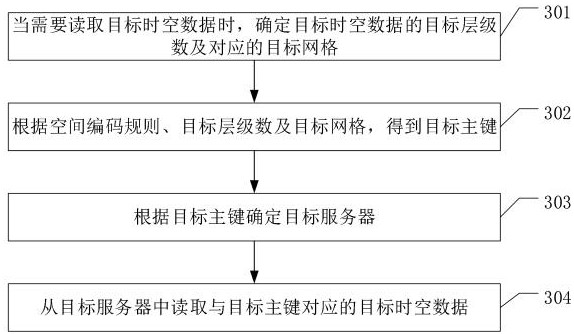
[0102] refer to image 3 The difference between this embodiment and the above embodiment 1 and embodiment 2 is that, after completing the spatio-temporal data storage process in the above embodiment, when it is necessary to read the spatio-temporal data from the columnar database, the specific steps include:

[0103] 301. When it is necessary to read the target spatio-temporal data, determine the target level number of the target spatio-temporal data and the corresponding target grid.

[0104] Among them, if the user needs to read the target spatiotemporal data from the columnar database, the target hierarchy number of the target spatiotemporal data and the target spatiotemporal The target grid to which the data corresponds.

[0105] 302. Obtain the target primary key according to the spatial encoding rule, the number of target levels, and the target grid.

[0106] Wherein, combining the generation process of the primary key in Embodiment 2, combining the spatial coding rule...


PUM


Abstract

The invention relates to a spatial-temporal data management method and system, a host and a computer readable storage medium. The method comprises the following steps: acquiring spatial-temporal data; layering the spatial-temporal data, and coding the layered spatial-temporal data according to a spatial coding rule to obtain a primary key; and according to a fragmentation storage rule, dividing the spatial-temporal data according to the primary key, and then storing divided data in to servers in a column database. According to the method, the storage capability and the retrieval efficiency of the spatial-temporal data can be improved.

Description

technical field [0001] The present application relates to the field of data processing, in particular to a spatio-temporal data management method, system, host and computer-readable storage medium. Background technique [0002] With the continuous accumulation of geographic information vector and image data, the amount of data continues to increase. Related technologies generally store geographic information data into relational databases such as Oracle, SQLServer, and PostgreSQL. [0003] However, when reading geographic information data, using the index rules of relational databases for retrieval can no longer meet the management needs of massive spatio-temporal data. There is an upper limit for input and output (IO), which cannot meet the needs of efficient storage of massive spatio-temporal data. Multiple servers need to be combined for simultaneous processing. Due to the design characteristics of relational databases, fragmented storage is not considered, and it does no...

Claims


Application Information

Patent Timeline
Patent Type & Authority Applications(China)
IPC IPC(8): G06F16/22G06F16/2458G06F16/29
CPCG06F16/221G06F16/2458G06F16/29
Inventor 郭双仁唐芝青唐先龙胡恬全思湘张泰伏镭
Owner 湖南省第二测绘院
Why Eureka
Try Eureka