Satellite image low-coherence region identification method and device based on deep learning

A technology for region recognition and satellite imagery, applied in the field of satellite image processing, can solve the problems of limited samples, difficulty, and increase in low-coherence region recognition, and achieve the effect of alleviating the recognition effect and reducing dependence.

Pending Publication Date: 2021-07-02
中科星图空间技术有限公司
View PDF0 Cites 6 Cited by
  • Summary
  • Abstract
  • Description
  • Claims
  • Application Information

AI Technical Summary

Problems solved by technology

However, for the low-coherence areas formed by radar shadows, overlaps, and smooth planes (water surfaces) caused by the imaging characteristics of SAR images, plus the time-distance decoherence caused by repeated orbits and formation flight problems, various complex factors Superimposed together, it adds difficulties to the low-coherence area identification of the Tianhui-2 satellite. In addition, the combination of deep learning and SAR image recognition technology still faces challenges in the following aspects: 1. Intra-class differences in SAR low-coherence areas The similarity between classes and classes increases the difficulty of extraction; 2. The SAR images in different seasons and different regions are significantly different, and the prediction ability of the model fluctuates greatly among data sets of different time periods; 3. Because the Tianhui-2 satellite needs to guarantee global surveying and mapping task, the data is massive, but the samples available for supervised training are very limited

Method used


Image

  • Satellite image low-coherence region identification method and device based on deep learning
  • Satellite image low-coherence region identification method and device based on deep learning
  • Satellite image low-coherence region identification method and device based on deep learning

Examples


Embodiment 1

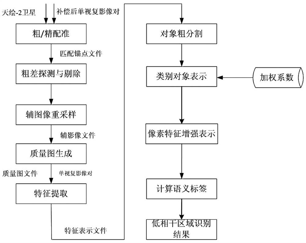
[0040]The method for identifying low-coherence regions of satellite images based on deep learning described in this embodiment, such as figure 1 As shown, it includes the following specific steps: Step 1, sub-pixel level registration; align two InSAR single-view complex image pairs through the measure function, and obtain a set of matching points;

[0041] Step 2, Gross error detection and elimination; Eliminate the mismatching points in the matching point set obtained in step 1;

[0042] Step 3, auxiliary image resampling; according to the matching point set obtained in step 2 after elimination, polynomial fitting is performed on the registration offset between the main image and the auxiliary image, a polynomial registration model is established, and the auxiliary image The image is resampled;

[0043] Step 4, quality map generation; Generate a correlation coefficient matrix, i.e. a quality map, according to the main image and the auxiliary image;

[0044] Step 5, extracti...

Embodiment 2

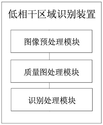
[0084] In another embodiment of the present disclosure, the satellite image low-coherence area identification device based on deep learning, such as image 3 As shown, it includes image preprocessing module, quality image processing module and recognition processing module.

[0085] The image preprocessing module is used to align the SAR images through the measurement function to obtain a set of matching points; eliminate the false matching points in the set of matching points; perform polynomial simulation on the registration offset between the main image and the auxiliary image Combined, a polynomial registration model is established, and the auxiliary image is resampled.

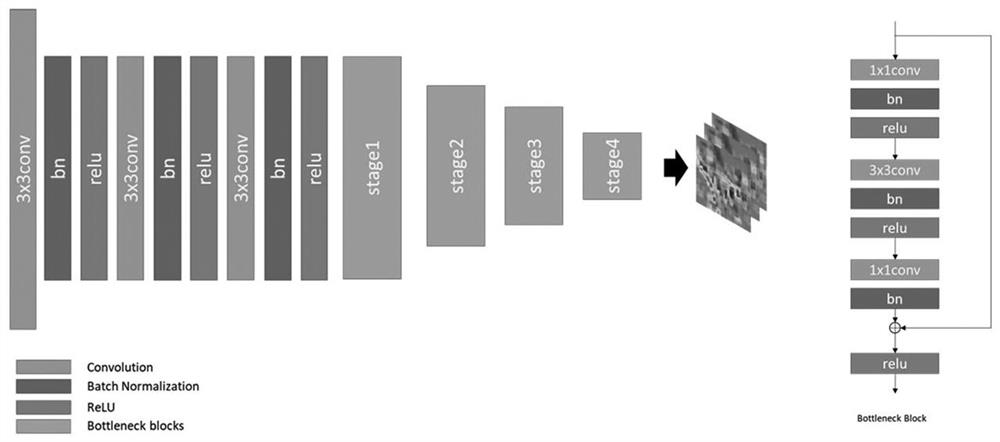
[0086] The quality map processing module is used to generate a correlation coefficient matrix according to the main image and the auxiliary image, that is, the quality map; then use a multi-layer stacked convolutional neural network to extract image features in a data-driven manner to obtain an image feat...

Embodiment 3

[0089] According to another specific embodiment of the present disclosure, the electronic device for identifying low-coherence areas of satellite images based on deep learning includes a memory and a processor; the memory is used to store computer programs; the processor is used to execute the computer During the program, the computer is made to execute the deep learning-based satellite image low-coherence area identification method described in the first embodiment above, and the specific identification steps are the same as those in the first embodiment above, and will not be repeated here.


PUM


Abstract

A satellite image low-coherence region identification method and device based on deep learning belong to the field of satellite image processing, and are characterized in that a quality map obtained by SAR image processing is combined with semantic segmentation to form a process learning framework, and a deep convolutional network is introduced for identification. Compared with manual interpretation and a traditional machine learning algorithm, the low-coherence region recognition method based on deep learning greatly reduces dependence on artificial feature engineering and sample data, and a large-range region can be quickly processed based on high efficiency of convolution calculation; meanwhile, on the basis of introducing global attention, relation representation between pixel positions and semantic categories is further described, the recognition effect of inherent high-noise areas of the SAR image is relieved, the recognition precision is improved on the premise that the calculated amount is not remarkably increased, and low-coherence areas are accurately extracted.

Description

technical field [0001] The invention belongs to the field of satellite image processing, in particular to a method and device for identifying low-coherence regions of satellite images based on deep learning. Background technique [0002] Synthetic Aperture Radar Interferometry (InSAR) is a space-to-earth observation technology that uses phase information to extract ground elevation. It has the characteristics of all-day, all-weather, high precision, and large area. It has been widely used and made outstanding contributions to the development of the national economy and national security. [0003] Tianhui-2 satellite is the first microwave and terrain surveying and mapping satellite independently developed by my country based on the formation system. It uses InSAR technology to efficiently obtain high-precision DEM data. However, due to the complexity of InSAR technology, there are still many problems. It has been essentially solved, such as the problem of decoherence of the ...

Claims


Application Information

Patent Timeline
Patent Type & Authority Applications(China)
IPC IPC(8): G06K9/00G06K9/34G06K9/36G06K9/46G06N3/04G06N3/08
CPCG06N3/08G06V20/13G06V10/26G06V10/20G06V10/462G06N3/045
Inventor 杨庆庆薛博维
Owner 中科星图空间技术有限公司
Why Eureka
Try Eureka